Welcome to MountainViews
If you want to use the website often please enrol (quick and free) at top right.
If you want to use the website often please enrol (quick and free) at top right.
Overview

For more map options click on any overview map area or any detail map feature.
Detail Map Features
Showing 6 items:
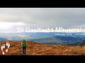
Mullaghanish Far North-East Top 558.5m, Curracahill 478m, Ballyvouskill 401m,
4412, 8km
3957, 7km
1116, 5km
Mullaghanish Far North-East Top 558.5m, Curracahill 478m, Ballyvouskill 401m,
Tracks:
Find Suggested Walks
Find hill, mountain, island, coastal feature.
Videos
Recent Contributions
 Get Notifications
Get Notifications
Carricktriss Gorse: Safe access to this hill no longer seems possible
 TommyMc
Binnion: Tullagh Bay and Rockstown Harbour
 Jim_Brady
Donations Drive, now finished.
Good, relatively easy double bag
 Colin Murphy
Crocknapeast: Long walk up windfarm roads.
 Collaborative entry
Mulnanaff: Longish walk up windfarm road.
 Collaborative entry
Lake District: Dale Head Horseshoe
Double bag mostly on windfarm tracks.
 Colin Murphy
Binbane NE Top: Simple bag from its neighbouring top.
 Collaborative entry
Lake District: Coledale Horseshoe
Binbane: Steepish approach to relatively easy Carn.
 Collaborative entry
Crucknaree: Magnificent views!
 paddyhillsbagger
Conditions and Info
Use of MountainViews is governed by conditions and a privacy policy.
Read general information about the site.
Opinions in material here are not necessarily endorsed by MountainViews.
Hillwalking is a risk sport. Information in comments, walks, shared GPS tracks or about starting places may not be accurate for example as regards safety or access permission. You are responsible for your safety and your permission to walk.
See the credits and list definitions.
 Visit our Facebook page.
Video display
Derrynasaggart
Area SE: Mullaghanish Subarea
Place count in area: 24,
OSI/LPS Maps: 79
Highest place: The Paps East, 694m
Maximum height for area: 694 metres,
Maximum prominence for area: 623 metres,
Places in area Derrynasaggart:
Cen: Knocknabro:Knocknabro East Top 530mKnocknabro NE Top 535mKnocknabro West Top 592mKnocknagowan 574m
N: Caherbarnagh:Caherbarnagh 681mCaherbarnagh East Top 549mCaherbarnagh NW Top 668mClaragh Mountain 452mCurracahill 478m
SE: Mullaghanish:Ballyvouskill 401mKnockacommeen 426mKnockullane 462mKnockullane East Top 408mMullaghanish 649mMullaghanish North-East Top 586.4mMullaghanish Far North-East Top 558.5m
SW: Coomagearlahy:Knockbwee 461mCummeenboy 442mCoomagearlahy 506mCoomagearlahy West Top 462mDereenaculling 303m
W: The Paps:Coolcurtoga 425mThe Paps East 694mThe Paps West 690m
Note: this list of places includes island features such as summits, but not islands as such.
Highest place:
The Paps East, 694mPlaces in area Derrynasaggart:
Cen: Knocknabro:
Knocknabro East Top 530mKnocknabro NE Top 535mKnocknabro West Top 592mKnocknagowan 574mN: Caherbarnagh:
Caherbarnagh 681mCaherbarnagh East Top 549mCaherbarnagh NW Top 668mClaragh Mountain 452mCurracahill 478mSE: Mullaghanish:
Ballyvouskill 401mKnockacommeen 426mKnockullane 462mKnockullane East Top 408mMullaghanish 649mMullaghanish North-East Top 586.4mMullaghanish Far North-East Top 558.5mSW: Coomagearlahy:
Knockbwee 461mCummeenboy 442mCoomagearlahy 506mCoomagearlahy West Top 462mDereenaculling 303mW: The Paps:
Coolcurtoga 425mThe Paps East 694mThe Paps West 690mNote: this list of places includes island features such as summits, but not islands as such.

Bedrock type: Green sandstone & purple siltstone, (Glenflesk Chloritic Sandstone Formation)
Ballyvouskill is the 945th highest place in Ireland. Ballyvouskill is the most easterly summit in the Derrynasaggart area.
Linkback: https://mountainviews.ie/summit/830/
COMMENTS for Ballyvouskill 1 of 1  Follow this place's comments

|
|
|
|
||
| MountainViews.ie, a Hill-walking Website for the island of Ireland. 2400 Summiteers, 1480 Contributors, maintainer of lists: Arderins, Vandeleur-Lynams, Highest Hundred, County Highpoints etc | |||