Donation Request 2024

DONATE
Members and Supporters, the MountainViews Committee requests your help to meet the costs of the website and of other activities such as insured events or publications.
You do not have to be logged in to donate.
Features
Nearby features appear when you click the map.
Declutter tracks on map.
Place Search
Video
X
Pub: by
Derrynasaggart Area , N: Caherbarnagh Subarea
Feature count in area: 24, by county: Kerry: 12, Cork: 14, of which 2 are in both Cork and Kerry, OSI/LPS Maps: 79
Highest Place: The Paps East 694m

Starting Places (28) in area Derrynasaggart:
Carrigallisy, Clonee, Dromiscane Castle, Fuhiry Wood, Garrane Bridge, Garries Bridge, Glannafreaghaun Lough N, Glannafreaghaun Lough S1, Glannafreaghaun Lough S2, Gortavehy Lough, Grousemount Wind Farm, Inchamore Woods N, Inchamore Woods W, Kippagh Lough, Knocknabro Wood, Knockullane, Liam Hegarty Monument, Loo River Junction, Lough Murtagh, Millstreet, Mullaghanish Transmitter Gate, Old Rail Level Crossing, Paps Walk S, River Roughty, Rossacroo na Loo Forest, Sillahertane Stream, The Mills Inn, Top of Coom

Summits & other features in area Derrynasaggart:
Cen: Knocknabro: Knocknabro East Top 530m, Knocknabro NE Top 535m, Knocknabro West Top 592m, Knocknagowan 574m
N: Caherbarnagh: Caherbarnagh 681m, Caherbarnagh East Top 549m, Caherbarnagh NW Top 668m, Claragh Mountain 452m, Curracahill 478m
SE: Mullaghanish: Ballyvouskill 401m, Knockacommeen 426m, Knockullane 462m, Knockullane East Top 408m, Mullaghanish 649m, Mullaghanish North-East Top 586.4m, Mullaghanish Far North-East Top 558.5m
SW: Coomagearlahy: Knockbwee 461m, Cummeenboy 442m, Coomagearlahy 506m, Coomagearlahy West Top 462m, Dereenaculling 303m
W: The Paps: Coolcurtoga 425m, The Paps East 694m, The Paps West 690m

Note: this list of places may include island features such as summits, but not islands as such.
Rating graphic.
Caherbarnagh NW Top, 668m Mountain An Chathair Bhearnach (mullach thiar thuaidh) A name in Irish,
Place Rating ..
For origin of name, see Caherbarnagh., Cork County in Munster province, in Arderin Beg, Vandeleur-Lynam Lists, Caherbarnagh NW Top is the 162nd highest place in Ireland. Caherbarnagh NW Top is the second most northerly summit in the Derrynasaggart area.
Grid Reference W18778 87663, OS 1:50k mapsheet 79
Place visited by: 136 members, recently by: rhw, SeanPurcell, DeirdreM, NualaB, ToughSoles, Beti13, abcd, Sweeney, Peter Walker, farmerjoe, derekfanning, Krzysztof_K, jimmel567, sarahryanowen, Alanjm
I visited this place: NO (You need to be a logged-in member for this.)
Longitude: -9.184232, Latitude: 52.035525, Easting: 118778, Northing: 87663, Prominence: 23m,  Isolation: 0.6km
ITM: 518749 587721
Bedrock type: Green sandstone & purple siltstone, (Glenflesk Chloritic Sandstone Formation)
Notes on name: The name Glanaprehane probably refers to the steep glen N of Caherbarnagh rather than this peak.
  Short or GPS IDs, 6 char: ChrbNW, 10 char: ChrbrnNWTp

Linkback: https://mountainviews.ie/summit/157/
Gallery for Caherbarnagh NW Top (An Chathair Bhearnach (mullach thiar thuaidh)) and surrounds
Summary for Caherbarnagh NW Top (An Chathair Bhearnach (mullach thiar thuaidh)): Western outlier of Caherbarnagh
Summary created by simon3 2011-01-31 08:24:42
            MountainViews.ie picture about Caherbarnagh NW Top (<em>An Chathair Bhearnach (mullach thiar thuaidh)</em>)
Picture: Caherbarnagh NW from the SE
The summit overlooks great areas of Cork farmland and some of Kerry. There is a good view of the gracious Paps to the SW. It can be reached from the Duhallow Way to the north and east, with particular starting points such as A (W196 893) or B (B (W177 850)). Or make it part of a ridge walk from Caherbarnagh from which it is separated by around 650m and a NE facing corrie.
Going is good on the summit with short grass or heather though some of the lower slopes are harder. The exact top is somewhat vague.
Linkback: mountainviews.ie/summit/157/comment/4917/
Member Comments for Caherbarnagh NW Top (An Chathair Bhearnach (mullach thiar thuaidh))
Comment create / edit display placeholder

            MountainViews.ie picture about Caherbarnagh NW Top (<em>An Chathair Bhearnach (mullach thiar thuaidh)</em>)
Picture: Top of the Paps
jackill on Caherbarnagh NW Top
by jackill 14 Mar 2006
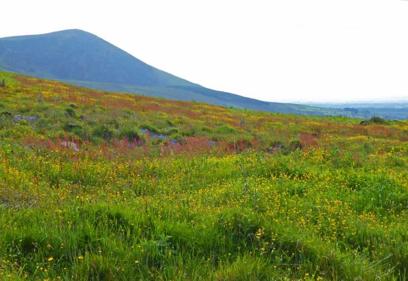
The Derrynasaggart mountains would not win any awards for their looks.
At first glance a vast, sodden expanse of bog carpeted in rough Ling and Tussock Sedge
that have made many a better man than me reach for his Lucozade.
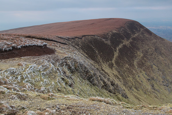
Look again though and the rich geological history of the area comes to light.
The sharp edge of Devonian Old Red Sandstone of the Derrynasaggarts wedged against the
older Namurian rocks to the north divided by the Killarney/Mallow faultline.
The rich glacial deposits piled against the northern slopes recall times when these
hills carried their own receding Ice-cap 130,000 years ago and somewhat obscure the impressive
fault scap which is visible in a only few places such as Lough Gortavehy.
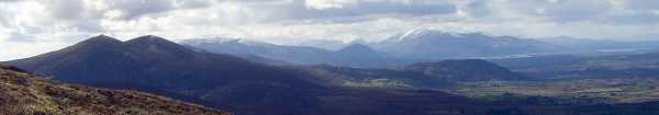
To the west the sensual Paps contrast with the violent, twisted slopes of Crohane and Stoompa rising above the tranquil Lough Guitane
betraying the outpourings of lava and volcanic deposits in the late Devonian era that formed them.
But enough of the geology lesson, what of the views? what of the views!
On a clear day in early March, the snow capped Kerry Highlands....... magnificent!
The photo was taken from the summit of Glanaprehane. Linkback: mountainviews.ie/summit/157/comment/2227/
Read Less
Read More

walker_hollick on Caherbarnagh NW Top
by walker_hollick 6 Feb 2005
A stopover on the way to or from Caherbarnagh. Walked along the Duhallow Way
then up to Glanaprehane, to Caherbarnagh, then eastwards along the ridge. The views were excellent but the terrain is a little boggy. If two cars are available it would be possible to
walk along the whole ridge from Knocknabro to Claragh mountain and then down to Millstreet. Linkback: mountainviews.ie/summit/157/comment/1463/
Read Less
Read More

            MountainViews.ie picture about Caherbarnagh NW Top (<em>An Chathair Bhearnach (mullach thiar thuaidh)</em>)
Picture: Glanaprehane
Lynchieboy on Caherbarnagh NW Top
by Lynchieboy 15 Apr 2006
Wish the view was as good as the photo by Jackhill the day I took my camera. Going up can often be easier than coming down and today we came down from Glanaprehane on the closer fallaway ridge by moving out to the end of it turning right near the end and then left again. Much easier to go up. The boggy soft ground is a help but a few more rocks would make a man feel safer on the way down. To go up, in my opinion its one of the best challenges to reach the higher Caherbarnagh apart from taking it straight on from the coom (very hard) or firstly ascending Stoukeen considering any ascent from the Clydagh valley is pretty damp. This said I would alternatley recommend an ascent from B (W177 850) as the driest from the Clydagh valley which is beautiful and long valley which is nice and quiet as there is only one way in and out for normal traffic. Linkback: mountainviews.ie/summit/157/comment/2277/
Read Less
Read More

Access Problems?
by redape99 2 Aug 2011
See my comment in Caherbarnagh. Linkback: mountainviews.ie/summit/157/comment/6452/
Read Less
Read More

            MountainViews.ie picture about Caherbarnagh NW Top (<em>An Chathair Bhearnach (mullach thiar thuaidh)</em>)
Wildflower heaven
by Colin Murphy 30 Jun 2021
The summer wildflowers were in full bloom as we set off from 5km east of Caherbarnagh NW top. Linkback: mountainviews.ie/summit/157/comment/23197/
Read Less
Read More
EDIT Point of Interest
text
Videos
Recent Contributions
x
Conditions and Info
Use of MountainViews is governed by conditions and a privacy policy.
Read general information about the site.
Opinions in material here are not necessarily endorsed by MountainViews.
Hillwalking is a risk sport. Information in comments, walks, shared GPS tracks or about starting places may not be accurate for example as regards safety or access permission. You are responsible for your safety and your permission to walk.
See the credits and list definitions.

OSi logo
OSNI/LPS logo
Open Street Map
(Various variations used.)
British summit data courtesy:
Database of British & Irish Hills