This website uses cookies, which are small text files that the website puts on your device to facilitate operation. Cookies help us provide a better service to you. They are used to track general user traffic information and to help the website function properly.
Feature count in area: 24, by county: Kerry: 12, Cork: 14, of which 2 are in both Cork and Kerry,
OSI/LPS Maps: 79
Highest Place: The Paps East 694m
Starting Places (28) in area Derrynasaggart: Carrigallisy, Clonee, Dromiscane Castle, Fuhiry Wood, Garrane Bridge, Garries Bridge, Glannafreaghaun Lough N, Glannafreaghaun Lough S1, Glannafreaghaun Lough S2, Gortavehy Lough, Grousemount Wind Farm, Inchamore Woods N, Inchamore Woods W, Kippagh Lough, Knocknabro Wood, Knockullane, Liam Hegarty Monument, Loo River Junction, Lough Murtagh, Millstreet, Mullaghanish Transmitter Gate, Old Rail Level Crossing, Paps Walk S, River Roughty, Rossacroo na Loo Forest, Sillahertane Stream, The Mills Inn, Top of Coom
Summits & other features in area Derrynasaggart: Cen: Knocknabro: Knocknabro East Top 530m, Knocknabro NE Top 535m, Knocknabro West Top 592m, Knocknagowan 574m N: Caherbarnagh: Caherbarnagh 681m, Caherbarnagh East Top 549m, Caherbarnagh NW Top 668m, Claragh Mountain 452m, Curracahill 478m SE: Mullaghanish: Ballyvouskill 401m, Knockacommeen 426m, Knockullane 462m, Knockullane East Top 408m, Mullaghanish 649m, Mullaghanish North-East Top 586.4m, Mullaghanish Far North-East Top 558.5m SW: Coomagearlahy: Knockbwee 461m, Cummeenboy 442m, Coomagearlahy 506m, Coomagearlahy West Top 462m, Dereenaculling 303m W: The Paps: Coolcurtoga 425m, The Paps East 694m, The Paps West 690m
Note: this list of places may include island features such as summits, but not
islands as such.
Knocknabro West Top, 592mMountain Cnoc na Breo (mullach thiar) A name in Irish,
Place Rating ..
poss. Ir. Cnoc na Breo [PDT], ‘hill of the cut’, Kerry County in Munster province, in Arderin Lists, Knocknabro West Top is the 314th highest place in Ireland.
Grid Reference W15378 85392,
OS 1:50k mapsheet 79 Place visited by: 71members, recently by: garrettd, abcd, farmerjoe, NualaB, johncusack, a3642278, Denis-Barry, nupat, mountainmike, Ulsterpooka, Hillwalker65, eoghancarton, jackos, annem, chelman7
I visited this place: NO (You need to be a logged-in member for this.)
Longitude: -9.23329, Latitude: 52.014629, Easting: 115378, Northing: 85392,
Prominence: 147m, Isolation: 1.4km ITM: 515344 585453 Bedrock type: Green sandstone & purple siltstone, (Glenflesk Chloritic Sandstone Formation) Notes on name: This is the highest of the three tops of Knocknabro. The peak marked as Knocknabro on OSi maps is somewhat lower (530m) than this peak. The origin of the name is uncertain. John O’Donovan suggested Cnoc na Bró, ‘hill of the quern’, though without any explanation of the name. Another possibility is that the final element is the same as in Broemountain. In Welsh briw means ‘cut’ or ‘wound’. This may refer to the declivity between the two peaks which forms a pass between Rathmore to the N and the Clydagh Valley to the S. See also Broemountain, Inishnabro and Brow Head.
Short or GPS IDs, 6 char: Knc592, 10 char: KncknbWstT Linkback: https://mountainviews.ie/summit/292/
Gallery for Knocknabro West Top (Cnoc na Breo (mullach thiar)) and surrounds
Summary
for Knocknabro West Top (Cnoc na Breo (mullach thiar)):
Drowning is never easy
Summary created by simon3, jackill
2012-12-12 17:23:36
Start at the track to Shrone at Paps Walk S (W145 840) where there is room to park 4-5 cars. Follow the track for approx 600 mtrs and turn off it onto a track that is not marked on the map , it looks like the farmer has constructed it in the last few years. This track allows you to gain some height (100 mtrs approx.) before you strike out across open mountain(or should that be bog). The summit is gained by a hard slog over rutted ground with very wet conditions underfoot. The summit it self is marked only by a small pond.
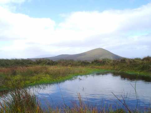
I seldom say this, but I am glad that having been here I don't have to go back. I started at the track to Shrone at A (W840 145) where there is room to park 4-5 cars. I followed the track for approx 600 mtrs and turned off it onto a track that is not marked on the map , it looks like the farmer has constructed it in the last few years. This track allowed me to gain some height (100 mtrs approx.) before I struck out across open mountain(or should that be bog). The summit is gained by a hard slog over rutted ground with very wet conditions underfoot. The summit it self is marked only by a small pond , there is no cairn because there are no stones with which to build one . There is however some compensation in the fine views back over the Paps to Killarney, to the Cahas to the south and the Boggeraghs . From the summit I headed for Knocknagowan.This was a 3km trudge across bog, full of holes, covered in knee-high heather and energy sapping long coarse grasses. By the time I got to Knocknagowan no amount of Lucozade could revive me. I would recommend anyone coming to this area avoid the bog between these two summits. The picture was taken on the summit of Knocknabro looking towards the Paps. Linkback: mountainviews.ie/summit/292/comment/1981/
Read Less
Read More
A Long Hard Slog
by CaminoPat
16 Jul 2018
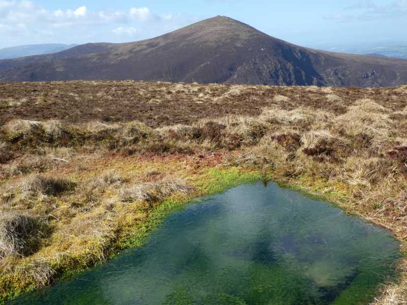
Park at laneway to old farmhouse now in ruin at B (W15905 83498). Room for 1-2 cars to park. Climb gate at entrance and follow post and wire fence heading north until C (W16029 84252). From there head across open hillside in a NNW direction. It is slow going across long grass and heather cover to the summit. As you gain altitude you will meet another post and wire fence coming up from the west, i.e. on your left hand side. Follow fence to summit which is located along the fence line. No obvious marker for summit other than a nearby very small lake, which on the day of the walk was almost dry. Fantastic views across the Blackwater Valley and to the west towards The Paps. Linkback: mountainviews.ie/summit/292/comment/19977/
Read Less
Read More
Picture: The Paps as seen from high point
Won't knock your socks off
by Colin Murphy
30 Mar 2022
Followed jackal's directions to the top. The farmer's track he references (off the main track) now has signs stating that it is private property, although no specifically forbidding walkers, which I took to be a good sign. It was very swampy initially, although became firm and grassy further up and relatively easy to navigate. I was doing this mountain essentially as a means of accessing the two Arderin Begs to the east, and like other contributors, would hold no great love for its heathery, almost featureless summit, except for the fine views it affords of the adjacent Paps. Less than an hour to the top and fine weather made the ascent relatively pleasant. Won't be back though! Linkback: mountainviews.ie/summit/292/comment/23457/
Use of MountainViews is governed by conditions and a privacy policy.
Read general information about the site. Opinions in material here are not necessarily endorsed by MountainViews.
Hillwalking is a risk sport. Information in comments, walks, shared GPS tracks or about starting places may
not be accurate for example as regards safety or access permission. You are responsible for your safety and your permission to walk.
See the credits and list definitions.


 Our Facebook page.