This website uses cookies, which are small text files that the website puts on your device to facilitate operation. Cookies help us provide a better service to you. They are used to track general user traffic information and to help the website function properly.
Feature count in area: 24, by county: Kerry: 12, Cork: 14, of which 2 are in both Cork and Kerry,
OSI/LPS Maps: 79
Highest Place: The Paps East 694m
Starting Places (28) in area Derrynasaggart: Carrigallisy, Clonee, Dromiscane Castle, Fuhiry Wood, Garrane Bridge, Garries Bridge, Glannafreaghaun Lough N, Glannafreaghaun Lough S1, Glannafreaghaun Lough S2, Gortavehy Lough, Grousemount Wind Farm, Inchamore Woods N, Inchamore Woods W, Kippagh Lough, Knocknabro Wood, Knockullane, Liam Hegarty Monument, Loo River Junction, Lough Murtagh, Millstreet, Mullaghanish Transmitter Gate, Old Rail Level Crossing, Paps Walk S, River Roughty, Rossacroo na Loo Forest, Sillahertane Stream, The Mills Inn, Top of Coom
Summits & other features in area Derrynasaggart: Cen: Knocknabro: Knocknabro East Top 530m, Knocknabro NE Top 535m, Knocknabro West Top 592m, Knocknagowan 574m N: Caherbarnagh: Caherbarnagh 681m, Caherbarnagh East Top 549m, Caherbarnagh NW Top 668m, Claragh Mountain 452m, Curracahill 478m SE: Mullaghanish: Ballyvouskill 401m, Knockacommeen 426m, Knockullane 462m, Knockullane East Top 408m, Mullaghanish 649m, Mullaghanish North-East Top 586.4m, Mullaghanish Far North-East Top 558.5m SW: Coomagearlahy: Knockbwee 461m, Cummeenboy 442m, Coomagearlahy 506m, Coomagearlahy West Top 462m, Dereenaculling 303m W: The Paps: Coolcurtoga 425m, The Paps East 694m, The Paps West 690m
Note: this list of places may include island features such as summits, but not
islands as such.
Mullaghanish North-East Top, 586.4mMountain Mullach an Ois (mullach thoir thuaidh) A name in Irish,
Place Rating ..
For origin of name, see Mullach an Ois / Mullaghanish., Cork/ Kerry County in Munster province, in Arderin Beg Lists, Mullach an Ois (mullach thoir thuaidh) is the 321st highest place in Ireland.
Grid Reference W22630 82708,
OS 1:50k mapsheet 79 Place visited by: 41members, recently by: abcd, Ulsterpooka, Grumbler, johncusack, a3642278, annem, John.geary, caiomhin, Colin Murphy, madfrankie, jackos, chelman7, Wilderness, Fergalh, Lauranna
I visited this place: NO (You need to be a logged-in member for this.)
Short or GPS IDs, 6 char: Mlg586, 10 char: MlghnsNrth Linkback: https://mountainviews.ie/summit/1407/
Gallery for Mullaghanish North-East Top (Mullach an Ois (mullach thoir thuaidh)) and surrounds
Summary
for Mullaghanish North-East Top (Mullach an Ois (mullach thoir thuaidh)):
A bagging exercise, no more.
Summary created by Colin Murphy
2022-01-17 17:13:22
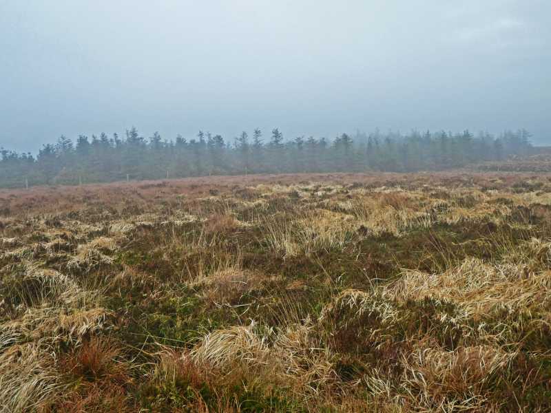
Picture: What passes for a high point.
On approach is from the SE. There is parking for several cars at CrgAlisy (W243 815) A, the entrance to a wind farm track. Follow the track up to A (W232 823) B and then climb over the bank of earth on the left resulting from the track's construction. Head directly west for about 300m, aiming for a gap in the forestry tucked into a corner. The terrain is rough clumps of long grass and heather and quite uneven, although there are a couple of sheep trails if you can find them. Cut through the woods for about 200m emerging into more open ground and turn NW for another few hundred metres, up gently rising but very uneven ground. The summit area is unmarked and quite bleak, especially in poor conditions.
There is a good forest track most of the way up, but you have to leave this for the last 500 M which is not too pleasant. Mullaghanish Far north east is much more easily reached from the same track. As the county border runs through the summit you have to be very careful not to cross from Cork into Kerry and thus break Covid level 3 restrictions ☺☺☺ Linkback: mountainviews.ie/summit/1407/comment/20916/
Read Less
Read More
Tiptoe through the trees
by thomas_g
1 Sep 2021
Parked at CrgAlisy (W24339 81472) at entrance to Wind Farm complex, room for 4 cars.
See track 3033 for a route that uses several firebreaks to form a loop walk that visits this and the Far NE top, the paths through the trees are not obvious.
Most of this route is through knee to waist high grass and heather and is tough going, it is probably more straightforward to use the road as much as possible to get as close as possible to each peak before braving the "jungle".
This top is also quite accessible from Mullaghanish top itself. Linkback: mountainviews.ie/summit/1407/comment/18201/
Use of MountainViews is governed by conditions and a privacy policy.
Read general information about the site. Opinions in material here are not necessarily endorsed by MountainViews.
Hillwalking is a risk sport. Information in comments, walks, shared GPS tracks or about starting places may
not be accurate for example as regards safety or access permission. You are responsible for your safety and your permission to walk.
See the credits and list definitions.


 Our Facebook page.