Members and Supporters, the MountainViews Committee requests your help to meet the costs of the website and of other activities such as insured events or publications.
Feature count in area: 24, by county: Kerry: 12, Cork: 14, of which 2 are in both Cork and Kerry,
OSI/LPS Maps: 79
Highest Place: The Paps East 694m
Starting Places (28) in area Derrynasaggart: Carrigallisy, Clonee, Dromiscane Castle, Fuhiry Wood, Garrane Bridge, Garries Bridge, Glannafreaghaun Lough N, Glannafreaghaun Lough S1, Glannafreaghaun Lough S2, Gortavehy Lough, Grousemount Wind Farm, Inchamore Woods N, Inchamore Woods W, Kippagh Lough, Knocknabro Wood, Knockullane, Liam Hegarty Monument, Loo River Junction, Lough Murtagh, Millstreet, Mullaghanish Transmitter Gate, Old Rail Level Crossing, Paps Walk S, River Roughty, Rossacroo na Loo Forest, Sillahertane Stream, The Mills Inn, Top of Coom
Summits & other features in area Derrynasaggart: Cen: Knocknabro: Knocknabro East Top 530m, Knocknabro NE Top 535m, Knocknabro West Top 592m, Knocknagowan 574m N: Caherbarnagh: Caherbarnagh 681m, Caherbarnagh East Top 549m, Caherbarnagh NW Top 668m, Claragh Mountain 452m, Curracahill 478m SE: Mullaghanish: Ballyvouskill 401m, Knockacommeen 426m, Knockullane 462m, Knockullane East Top 408m, Mullaghanish 649m, Mullaghanish North-East Top 586.4m, Mullaghanish Far North-East Top 558.5m SW: Coomagearlahy: Knockbwee 461m, Cummeenboy 442m, Coomagearlahy 506m, Coomagearlahy West Top 462m, Dereenaculling 303m W: The Paps: Coolcurtoga 425m, The Paps East 694m, The Paps West 690m
Note: this list of places may include island features such as summits, but not
islands as such.
Caherbarnagh, 681mMountain An Chathair Bhearnach A name in Irish,
Place Rating ..
(Ir. An Chathair Bhearnach [OSI], 'the gapped fort'), Cork County in Munster province, in Arderin, Vandeleur-Lynam, Irish Highest Hundred Lists, Caherbarnagh is the third highest mountain in the Derrynasaggart area and the 142nd highest in Ireland.
Grid Reference W19164 87170,
OS 1:50k mapsheet 79 Place visited by: 182members, recently by: Ianhhill, michaelseaver, knightsonhikes, rhw, Nailer1967, DeirdreM, ConMack23, MarionP, ToughSoles, abcd, Sweeney, Peter Walker, davsheen, Krzysztof_K, NualaB
I visited this place: NO (You need to be a logged-in member for this.)
Longitude: -9.178416, Latitude: 52.031044, Easting: 119164, Northing: 87170,
Prominence: 361m, Isolation: 0.6km, Has trig pillar
ITM: 519140 587216 Bedrock type: Green sandstone & purple siltstone, (Glenflesk Chloritic Sandstone Formation) Notes on name: See Máire MacNeill, 'The Festival of Lughnasa' (pp. 211-12) for details of the festive assembly which took place on Caherbarnagh on Latiaran Sunday in late July.
Short or GPS IDs, 6 char: Chrbrn, 10 char: Chrbrngh Linkback: https://mountainviews.ie/summit/135/
Gallery for Caherbarnagh (An Chathair Bhearnach) and surrounds
Summary
for Caherbarnagh (An Chathair Bhearnach):
Quiet, rounded summit overlooking some interesting geological features
Summary created by markmjcampion, aidand
2021-03-28 13:16:46
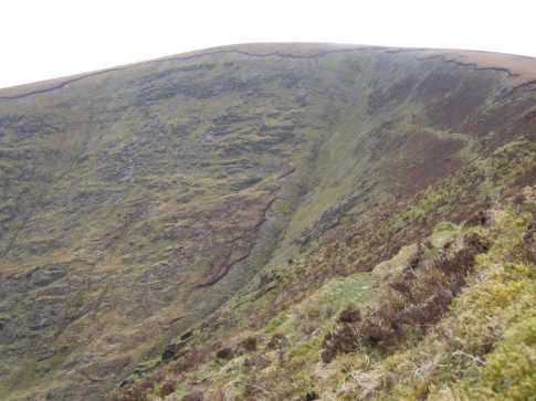
Picture: Caherbarnagh from Glanaprehane
Near The Paps, Caherbarnagh is a boggy flat top at the head of two interesting N-facing coums. It commands fine views over Sliabh Luachra, the Paps to Mangerton, Mullaghanish to the Cahas. There are access issues if trying to access via the Gortavehy Lough trail. I spoke with the relevant farmer here in mid-2020 and got the impression that a solo hiker might be given assent.
N. Space for a couple of cars outside a bungalow at L Murta (W19297 89194). Follow the Duhallow Way S and then E, leaving it at A (W18502 88560) to head steeply up to the NW Top – from here, a 15 min walk to the main summit taking care as cliffs abound on your left. 1.25hrs+
NE. If intending to head via Stoukeen and the lake track to it's north, it's imperative that you speak with the farmer first.
W. Park N of Shrone Lake and follow the D. Way to the E leaving it at B (W15015 87179) to pick up the N spur of Knocknabro W Top. From here, see below. 2hrs.
SW. Park near C (W15905 83498), climb gate at ruined farmhouse entrance and make your way up the grassy and heathery slopes to Knocknabro NE Top via the W Top. From here it's an easy stroll over to C although there's a steep gradient for the last 1.2km. Allow 2.5hrs
S. Park at KnNaBro Wd (W17252 83903) and walk E along the road, breaking out for the lower slopes after a stream. Head up the tussocky slopes of Knocknagowan from where it's a straightforward though boggy slog over to C. 1.5hrs+
Notable tracks incl. track/4157, track/4411 and if you've the time track/4096.
Had a walk today for Caherbarnagh using aidand’s instructions. As he noted there is no yellow man indicator to direct one up the laneway beside the bungalow at L Murta (W193 892). I took shaunkelly’s advice and called to the house for permission to enter the field before beginning the ascent. Met a nice man who had no problem whatsoever and he confirmed that that this was indeed the Duhallow way. So straight up thru two fields and the waymarkers soon appear. This connects to a farm roadway and on into a passageway with rocks strewn on both sides. On the right of the gate in the distance is a green stile like those in the Galtees, etc. As soon as you cross over the stile turn sharp right and you’ll see another smaller stile which leads down to the stream coming from Lough Murtagh. Care required here with a bar secured here to aid crossing, could be exciting with increased levels of water after heavy rain and greasy rocks. Over another stile and aim for the post with the yellow way marker. From there simply follow aidand’s directions.
On another issue one of the photographs I admired most from the guide to Ireland’s Mountains summits was the one with the trig pillar on Caherbarnagh. Sadly this view can no longer be seen as there is now a colossal fence running along the ridge coming up from the valley from Knockabro and heading off into the distance towards Stoukeen. The pillar is enclosed in fence wire and it is not possible to walk around it. I encountered quad tracks while coming from the NW top so my guess is that that’s how the materials were taken up. I had intended doing a loop walk towards Stoukeen but not being sure regarding access issues there I returned via the way I had come up. I’ll put up some pictures as soon as I get a chance to upload them. Linkback: mountainviews.ie/summit/135/comment/15279/
Read Less
Read More
pdtempan on Caherbarnagh
by pdtempan
2 Feb 2004
A group from the Sliabh Luachra Hillwalking Club, led by Paul Tempan, tackled Caherbarnagh and Claragh Mountain on Sunday January 25th. The day was fine and we had excellent views west towards the Reeks and Slieve Mish and east towards the Galtees and Ballyhoura Mountains. The stretch between Caherbarnagh and Claragh was rather longer than some people imagined when this walk was conceived 2 weeks earlier in the Red Fox Inn! The highlights of this walk are the views down to Gortavehy Lough from Stookeen and the summit of Claragh (ramparts of a Bronze Age hillfort and a very fine viewpoint). The cliffs near Gortavehy Lough are best appreciated from near Gortavehy Lough on the Duhallow Way, but you need to do this as a separate walk. Linkback: mountainviews.ie/summit/135/comment/836/
Read Less
Read More
Access Problems?
by redape99
2 Aug 2011
Went walking here on 31/7/11 but encountered a very angry local farmer on the way down from Stoukeen. First of all found that the track to Gortavehy Lake has a sign saying "No unauthorised access" so looked at the map and the track starting at L Kippa (W236 879) up to Curracahill and Stoukeen looked promising so chose that way. After an hour and a half came across another sign on a gate right under the cairn on Stoukeen displaying "PRIVATE PROPERTY, NO TRESPASSING, NO HILLWALKING". There's no way of seeing this sign until you're on top of it, without binoculars anyway even if it wasn't misty! This sign is also on both sides of the gate so it's unclear whether the Curracahill side is private or the summits or both. At first the farmer refused to let us back down to the car insisting we go back up the hill in the direction he'd seen us coming from. After saying I'd add a note to MV about the signs he eventually let us carry on. Met another local farmer at the car (this time much more ameniable) who told us a few sad tales of the big increase in the thefts in the area recently. Linkback: mountainviews.ie/summit/135/comment/6451/
Read Less
Read More
Statement from MI re access.
by simon3
1 Dec 2011
Following the access comments of redape99 MV passed on details of the issue to Mountaineering Ireland for the purposes of keeping other hillwalking interests informed. MI investigated the issue and have issued a statement as below which is useful in that it specifies more exactly where the problem is.
The good news is that Caherbarnagh, Caherbarnagh NW and other neighbouring summits Curracahill and Ballyvouskill can all be reached without any known access difficulties.
Stoukeen ridge and Duhallow Way
Mountaineering Ireland has been advised that the owners of a mountain area south west of Millstreet are no longer allowing access to their land. The closure affects a large area to the east of the summit of Caherbarnagh, taking in Lough Gortavehy, Coomacheo, Stoukeen and the ridge to the south east of Stoukeen as far as the broad saddle south of Kippagh Lough. Mountaineering Ireland has met with the landowners involved, but unfortunately could not achieve a resolution to the issue at this time.
Walkers should also note that the Duhallow Way in the Gortavehy area has been re-routed and no longer follows the line that is marked on Sheet 79 from the Ordnance Survey’s Discovery Series mapping. This will be updated on the third edition of Sheet 79 which is due out at the end of 2011. Marker posts are in place along the revised route. Linkback: mountainviews.ie/summit/135/comment/6637/
Read Less
Read More
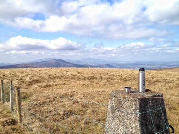
Picture: The Paps, some sun and a cuppa, not so shabby
Your hillwalking in Ireland when the trig point is the only dry spot for a mile
by thomas_g
1 Apr 2012
I came at Caherbarnagh from Knocknagowan, no access issues from the Clydagh valley (see my comments there), from this direction once you get to the flattish top you can choose to follow the fence north and then east, or climb the fence and head straight for the trig point. Either way it's fairly sapping boggy going.
Once you make it to the trig point, someone has thoughtfully provided two flat stones to sit on and have a cuppa. Views are decent in all directions, the Paps are particularly nice as you can see both summits from this angle.
While taking my ease with a cuppa, I met a local man who arrived at the summit from the Stoukeen direction, he says it's a much easier ascent and that there aren't any access issues from Gortavehy East: however, he did tell me there is a lot of hassle at the moment as the organisers of the Millstreet walking festival failed to ask the local landowners was it ok to bring the walking festival to Caherbarnagh via their land. So it might be best to give it a few months before attempting that route. To be honest it was a bit depressing to have someone tell you that Caherbarnagh was part of their usual loop walk for during the week.
If you're heading to Caherbarnagh NW and see any rocks, bring them with you (see my post there). Linkback: mountainviews.ie/summit/135/comment/6744/
Use of MountainViews is governed by conditions and a privacy policy.
Read general information about the site. Opinions in material here are not necessarily endorsed by MountainViews.
Hillwalking is a risk sport. Information in comments, walks, shared GPS tracks or about starting places may
not be accurate for example as regards safety or access permission. You are responsible for your safety and your permission to walk.
See the credits and list definitions.


 Our Facebook page.