This website uses cookies, which are small text files that the website puts on your device to facilitate operation. Cookies help us provide a better service to you. They are used to track general user traffic information and to help the website function properly.
Feature count in area: 24, by county: Kerry: 12, Cork: 14, of which 2 are in both Cork and Kerry,
OSI/LPS Maps: 79
Highest Place: The Paps East 694m
Starting Places (28) in area Derrynasaggart: Carrigallisy, Clonee, Dromiscane Castle, Fuhiry Wood, Garrane Bridge, Garries Bridge, Glannafreaghaun Lough N, Glannafreaghaun Lough S1, Glannafreaghaun Lough S2, Gortavehy Lough, Grousemount Wind Farm, Inchamore Woods N, Inchamore Woods W, Kippagh Lough, Knocknabro Wood, Knockullane, Liam Hegarty Monument, Loo River Junction, Lough Murtagh, Millstreet, Mullaghanish Transmitter Gate, Old Rail Level Crossing, Paps Walk S, River Roughty, Rossacroo na Loo Forest, Sillahertane Stream, The Mills Inn, Top of Coom
Summits & other features in area Derrynasaggart: Cen: Knocknabro: Knocknabro East Top 530m, Knocknabro NE Top 535m, Knocknabro West Top 592m, Knocknagowan 574m N: Caherbarnagh: Caherbarnagh 681m, Caherbarnagh East Top 549m, Caherbarnagh NW Top 668m, Claragh Mountain 452m, Curracahill 478m SE: Mullaghanish: Ballyvouskill 401m, Knockacommeen 426m, Knockullane 462m, Knockullane East Top 408m, Mullaghanish 649m, Mullaghanish North-East Top 586.4m, Mullaghanish Far North-East Top 558.5m SW: Coomagearlahy: Knockbwee 461m, Cummeenboy 442m, Coomagearlahy 506m, Coomagearlahy West Top 462m, Dereenaculling 303m W: The Paps: Coolcurtoga 425m, The Paps East 694m, The Paps West 690m
Note: this list of places may include island features such as summits, but not
islands as such.
Dereenaculling, 303mHill
Place Rating ..
, Cork County in Munster province, in no lists, Dereenaculling is the 1154th highest place in Ireland. Dereenaculling is the second most southerly summit in the Derrynasaggart area.
Grid Reference W15219 74675,
OS 1:50k mapsheet 79 Place visited by: 13members, recently by: Glanman2, thomas_g, markmjcampion, chelman7, Wildrover, daitho9, Fergalh, Daingean, Juanita, CaminoPat, eamonoc, jackill, conormcbandon
I visited this place: NO (You need to be a logged-in member for this.)
I summited this hill from the obvious farm track from the west. My GPS track is too short to upload. There is sort of space at the entrance to this farm track for one car. It's a quick trip passing a standing stone on the way up. There are fine views of Milane's northern cliffs. Linkback: mountainviews.ie/summit/1139/comment/17805/
Read Less
Read More
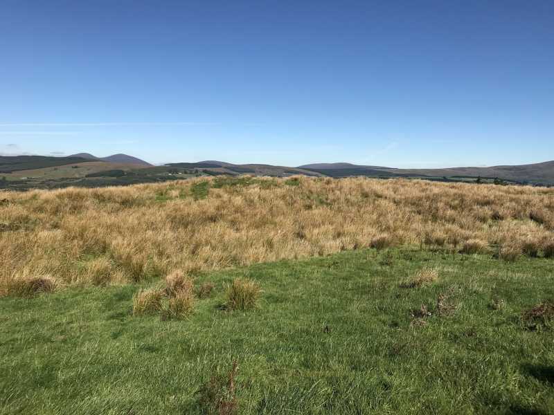
Picture: Little summit but large vista
Short walk for panoramic views
by CaminoPat
1 Oct 2018
Parked at A (W15026 74792) at entrance to farmland access road. Room for 2-3 cars. Walked uphill to highest point on access road and then turned left to reach summit at B (W15219 74675). No obvious marker on summit ,which is located on a raised rough grass earthen embankment. Only takes 15-20 minutes for round trip, but worth the walk if only for the magnificent views from the summit of the Derrynasaggart mountain range. Linkback: mountainviews.ie/summit/1139/comment/20074/
Use of MountainViews is governed by conditions and a privacy policy.
Read general information about the site. Opinions in material here are not necessarily endorsed by MountainViews.
Hillwalking is a risk sport. Information in comments, walks, shared GPS tracks or about starting places may
not be accurate for example as regards safety or access permission. You are responsible for your safety and your permission to walk.
See the credits and list definitions.


 Our Facebook page.