Donation Request 2024

DONATE
Members and Supporters, the MountainViews Committee requests your help to meet the costs of the website and of other activities such as insured events or publications.
You do not have to be logged in to donate.
Features
Nearby features appear when you click the map.
Declutter tracks on map.
Place Search
Video
X
Pub: by
Derrynasaggart Area , W: The Paps Subarea
Feature count in area: 24, by county: Kerry: 12, Cork: 14, of which 2 are in both Cork and Kerry, OSI/LPS Maps: 79
Highest Place: The Paps East 694m

Starting Places (28) in area Derrynasaggart:
Carrigallisy, Clonee, Dromiscane Castle, Fuhiry Wood, Garrane Bridge, Garries Bridge, Glannafreaghaun Lough N, Glannafreaghaun Lough S1, Glannafreaghaun Lough S2, Gortavehy Lough, Grousemount Wind Farm, Inchamore Woods N, Inchamore Woods W, Kippagh Lough, Knocknabro Wood, Knockullane, Liam Hegarty Monument, Loo River Junction, Lough Murtagh, Millstreet, Mullaghanish Transmitter Gate, Old Rail Level Crossing, Paps Walk S, River Roughty, Rossacroo na Loo Forest, Sillahertane Stream, The Mills Inn, Top of Coom

Summits & other features in area Derrynasaggart:
Cen: Knocknabro: Knocknabro East Top 530m, Knocknabro NE Top 535m, Knocknabro West Top 592m, Knocknagowan 574m
N: Caherbarnagh: Caherbarnagh 681m, Caherbarnagh East Top 549m, Caherbarnagh NW Top 668m, Claragh Mountain 452m, Curracahill 478m
SE: Mullaghanish: Ballyvouskill 401m, Knockacommeen 426m, Knockullane 462m, Knockullane East Top 408m, Mullaghanish 649m, Mullaghanish North-East Top 586.4m, Mullaghanish Far North-East Top 558.5m
SW: Coomagearlahy: Knockbwee 461m, Cummeenboy 442m, Coomagearlahy 506m, Coomagearlahy West Top 462m, Dereenaculling 303m
W: The Paps: Coolcurtoga 425m, The Paps East 694m, The Paps West 690m

Note: this list of places may include island features such as summits, but not islands as such.
Rating graphic.
The Paps West, 690m Mountain An Dá Chích Anann - An Chíoch Thiar A name in Irish,
Place Rating ..
(Ir. An Dá Chích [OSI], 'the two breasts'), Kerry County in Munster province, in Arderin, Vandeleur-Lynam, Irish Highest Hundred Lists, The Paps West is the second highest mountain in the Derrynasaggart area and the 127th highest in Ireland.
Grid Reference W12502 85525, OS 1:50k mapsheet 79
Place visited by: 340 members, recently by: kieran117, michaelseaver, rhw, Nailer1967, westside, maryblewitt, Petecal423, Leatra, Deirdreb, orlaithfitz, knightsonhikes, Cunn2000, ConMack23, ger.obrien, Chopper
I visited this place: NO (You need to be a logged-in member for this.)
Longitude: -9.275243, Latitude: 52.01527, Easting: 112502, Northing: 85525, Prominence: 106m,  Isolation: 0.8km, Has trig pillar
ITM: 512466 585574
Bedrock type: Green sandstone & purple siltstone, (Glenflesk Chloritic Sandstone Formation)
Notes on name: The Dictionary of Celtic Mythology gives the full name as Dá Chích Anann, 'the two breasts of Anu'. This goddess, also called Danu, was reputedly responsible for the fertility of the whole province of Munster. The summit cairns on both peaks, believed to be prehistoric, resemble nipples on the breasts. Strangely enough, the two peaks have the rounded aspect of a comely maiden's figure when viewed from the north-west (Killarney) or south-east (Ballyvourney), but have a triangular profile more reminiscent of a war goddess's breastplate when seen from the north-east (Rathmore) or south-west (Kenmare).
  Short or GPS IDs, 6 char: ThPpsW, 10 char: ThPpsWst

Linkback: https://mountainviews.ie/summit/125/
Gallery for The Paps West (An Dá Chích Anann - An Chíoch Thiar) and surrounds
Summary for The Paps West (An Dá Chích Anann - An Chíoch Thiar): Grassy, well defined peak with great views
Summary created by markmjcampion 2023-09-14 16:51:38
            MountainViews.ie picture about The Paps West (<em>An Dá Chích Anann - An Chíoch Thiar</em>)
Picture: The West Pap taken from its neighbour
The West Pap is the slightly smaller of the pair which together are two of the most recognisable Irish peaks. It's grassy and heathery with a huge cairn which is thought to cover an ancient burial chamber. Great views of the Mangerton group, Derrynasaggarts and the plains of N Kerry.

W. Park either in the Clydagh Valley at Paps Walk S (W14446 84029) or near Lough Glannafreaghaun at approx. A (W14760 86863) and head along the track to Gl'frekan S2 (W14304 85244). There are a no. of inconsistent tracks in this area that will take you through the steep, heather-covered lower slopes to the higher ground which has less vegetation. After the East Pap descend due west to a col before re-ascending to the West Pap. Allow 3 hrs+ up and back.

S. From the south park at a forest at Clonee (W12927 83233), walk 200m along the road to another forest exit. After this on left a hole in the hedge allows one to follow the forest fence uphill to another fence at B (W12956 83777). After crossing this continue to Rodgers Rock at C (W12597 84177) F and it's an easy ascent from here.

W. From the west park near Garrie's bridge at Garr Bge (W08152 83703) and follow the road N. At a sharp bend go through a gate and follow the good track winding up through charming farmland to D (W08879 84580). Keep on the track heading E up the well defined valley N of Coolcurtoga until it ends at a fence near E (W11968 84754). Follow the fence to the S spur of the W pap and go directly to the summit along a grassy track. Allow 2 hrs+ for this ascent.

Notable tracks incl track/3391 and track/4096.
Linkback: mountainviews.ie/summit/125/comment/4885/
Member Comments for The Paps West (An Dá Chích Anann - An Chíoch Thiar)
Comment create / edit display placeholder

            MountainViews.ie picture about The Paps West (<em>An Dá Chích Anann - An Chíoch Thiar</em>)
The recognisable Paps.
by jackill 30 Jan 2011
The Paps are perhaps two of the most recognizable mountains in Ireland when viewed for their northern or southern approaches.
I found myself in Killarney at 1.30 pm on the third of January last when a brief stop
at the office to check my emails on the way took three hours - the joys of working!
I paid a quick visit to the Sport Corran Tuathail to buy a copy of OS map 79 as naturally I had managed to forget my own.
I headed out the Cork road to eventually arrive at my start point Paps Walk S (W145 840) at about 2.00pm,
much later than I would have liked.
There is plenty of room to park four or five cars here without being in anyone’s way.
I wasted no time in setting out up the track towards Lough Glannafreaghaun, past the sign written in marker on a plastic bucket lid for " Shrone, The City”. Does anyone have a clue what its supposed to refer to?
On the way up this track you pass through three gates and after the third you emerge beyond the trees marked on the map.
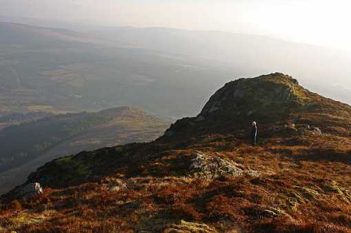
There is nothing for it but to start the steep climb up the first Pap (I don't mean to be rude).
After approx. 100 meters of height is gained to the first crest go left for 50 meters before again climbing again to the right along a wide, steep cleft in the hill.
This avoids having to struggle through the rough boggy very steep stream bed if you just went straight on.
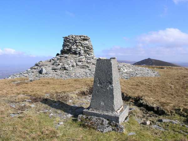
The summits of both these mountains are marked with large Cairns which apparently cover ancient tombs.
From the Paps east a descent of approx. 100 meters brings you to the col and then its another sharp climb up the Paps west of 100 meters. I headed back down to the col and then contoured around to get back to the track I had walked in on.
I arrived back at the car just as it was getting dark at around 5.00pm.
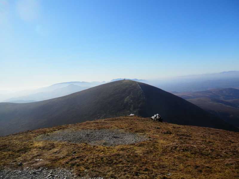
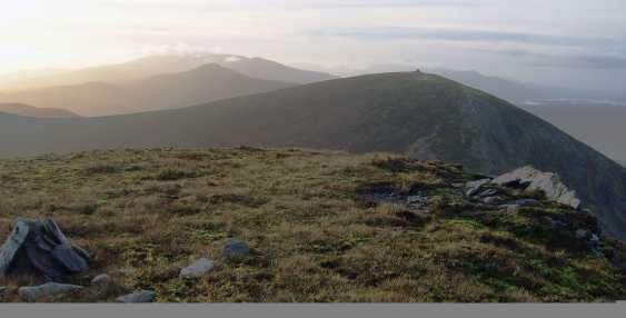
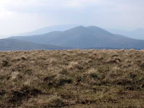
The photo was taken just before sunset from the Paps east with the Paps west in the center and behind are Crohane, Stoompa, Mangerton and the Reeks over the Lakes of Killarney.
A little bit of a sprint to finish before dark but what excellent views! Linkback: mountainviews.ie/summit/125/comment/2144/
Read Less
Read More

            MountainViews.ie picture about The Paps West (<em>An Dá Chích Anann - An Chíoch Thiar</em>)
Picture: Pap West with Pap East in the background
Southern approach
by riverlaune 12 Dec 2012
I have posted this comment on the Pap East comments, but thought it might be useful to have it here as well as most hillwalkers will bag both summits on the same walk! It also gives me an excuse to upload another photo!

We parked at Paps Walk S (W14446 84029) (Point A) in the Clydagh Valley and followed the ancient Duhallow trail towards Rathmore. As you walk up the trail you will see Pap East on the left handside in the distance(weather permitting!). An excellent guide to the walk can be found in Kevin Corcoran's book, 'Kerry Walks'. In previous comments a number of fellow walkers have taken the 'fire break' trail up Pap East but found it very slippery and muddy. We decided to take a track on the left hand side(after the 2nd gate) at Gl'frekan S2 (W14304 85244) (Point B), which proved to be an excellent way up the mountain. There is a heathery scramble to the summit after the trail peters out, but it is a fairly straightforward route which avoids the 'fire break'. From East Pap and its huge cairn, we walked to West Pap and then as pre-arranged, the clouds parted and we devoured a well deserved lunch, with superb views over Cork and Kerry! Linkback: mountainviews.ie/summit/125/comment/4552/
Read Less
Read More

            MountainViews.ie picture about The Paps West (<em>An Dá Chích Anann - An Chíoch Thiar</em>)
Picture: Nearly there!
Geo on The Paps West
by Geo 23 Feb 2010
Day three of a Kerry weekend and on the way home we thought The Paps would be nice on a Sunday morning. Parked at Forest at Clonee (W12927 83233) and walked a couple of hundred metres further along the road to another forest exit. Immediately after this on left a hole in the hedge allows one to follow the forest fence uphill to another fence at B (W12956 83777). After crossing this continure upwards and you get to Rodgers Rock (marked as a spot height on OS) at C (W12597 84177) in a little under an hour from the car. From here continue N along a fence and its hard to miss Pap West! We were on its summit with its cairn and trig in an hour and a half. Not a very demanding climb, but what a view! Linkback: mountainviews.ie/summit/125/comment/4431/
Read Less
Read More

            MountainViews.ie picture about The Paps West (<em>An Dá Chích Anann - An Chíoch Thiar</em>)
Picture: n22 view from the spur
rossbeighed on The Paps West
by rossbeighed 17 Mar 2009
Climbed the western pap in the derrynasaggarts via the spur (rodgers rock).
assumed this would be easier than going via shrone lake on the rathmore side.
parked the car about 2 miles east of cloonkeen and climbed from large cutting. looks like theres plenty of space for parking here. the tough part is the climb up to the spur which gets quite steep. from the spur its relatively straight forward as you have both peaks straight in front of you.
there was a hazy mist from the top but Id say on a clear day probably the best view in ireland. have to come up again on a clear day to see that kerry expanse:)
even with the mist the view towards kerry Linkback: mountainviews.ie/summit/125/comment/3647/
Read Less
Read More

            MountainViews.ie picture about The Paps West (<em>An Dá Chích Anann - An Chíoch Thiar</em>)
Picture: Looking back towards the Paps from Caherbarnagh
johnvbrennan on The Paps West
by johnvbrennan 16 May 2005
A group of us from Ballyhoura Bears walking club did the Paps in May. We were very fortunate with the weather which offered us fabulous views of the Reeks and Mangerton. We left our cars in Millstreet and hired a minibus to bring us to the starting point in Glenflesk Co. Kerry. We then walked the entire ridge back to Millstreet in Co. Cork. Along the way we took in both East and West Paps, Caherbarnagh. We finished with Claragh mountain in Millstreet. Total journey time was just under 7 hours. The ground from Caherbarnagh to the foot of Claragh is tough under foot and if it had been a wet day I am sure it's the kind of ground that would soak the energy out of you pretty quickly. Linkback: mountainviews.ie/summit/125/comment/1695/
Read Less
Read More
EDIT Point of Interest
text
Videos

Recent Contributions
x
Conditions and Info
Use of MountainViews is governed by conditions and a privacy policy.
Read general information about the site.
Opinions in material here are not necessarily endorsed by MountainViews.
Hillwalking is a risk sport. Information in comments, walks, shared GPS tracks or about starting places may not be accurate for example as regards safety or access permission. You are responsible for your safety and your permission to walk.
See the credits and list definitions.

OSi logo
OSNI/LPS logo
Open Street Map
(Various variations used.)
British summit data courtesy:
Database of British & Irish Hills