Welcome to MountainViews
If you want to use the website often please enrol (quick and free) at top right.
If you want to use the website often please enrol (quick and free) at top right.
Overview

For more map options click on any overview map area or any detail map feature.
Detail Map Features
Showing 13 of a total of 48 items:
Knockeenatoung 601.3m, Seefin 446.6m, Seefin North Top 444.1m,
4238, 32km
2303, 27km
2766, 22km
3230, 22km
2445, 21km
4487, 20km
1549, 17km
3427, 16km
3772, 16km
2874, 16km
Knockeenatoung 601.3m, Seefin 446.6m, Seefin North Top 444.1m,
Tracks:
Find Suggested Walks
Find hill, mountain, island, coastal feature.
Videos
Recent Contributions
 Get Notifications
Get Notifications
Carricktriss Gorse: Safe access to this hill no longer seems possible
 TommyMc
Donations Drive, now finished.
Binnion: Tullagh Bay and Rockstown Harbour
 Jim_Brady
Crocknapeast: Long walk up windfarm roads.
 Collaborative entry
Good, relatively easy double bag
 Colin Murphy
Mulnanaff: Longish walk up windfarm road.
 Collaborative entry
Double bag mostly on windfarm tracks.
 Colin Murphy
Binbane NE Top: Simple bag from its neighbouring top.
 Collaborative entry
Lake District: Dale Head Horseshoe
Binbane: Steepish approach to relatively easy Carn.
 Collaborative entry
Lake District: Coledale Horseshoe
Crucknaree: Magnificent views!
 paddyhillsbagger
Conditions and Info
Use of MountainViews is governed by conditions and a privacy policy.
Read general information about the site.
Opinions in material here are not necessarily endorsed by MountainViews.
Hillwalking is a risk sport. Information in comments, walks, shared GPS tracks or about starting places may not be accurate for example as regards safety or access permission. You are responsible for your safety and your permission to walk.
See the credits and list definitions.
 Visit our Facebook page.
Video display
Galty Mountains
Area Cen: Central Galtys Subarea
Place count in area: 24,
OSI/LPS Maps: 66, 74, EW-G
Highest place: Galtymore, 917.9m
Maximum height for area: 917.9 metres,
Maximum prominence for area: 820 metres,
Places in area Galty Mountains:
Cen: Central Galtys:Cush 641.2mGaltybeg 799.2mGaltymore 917.9mGreenane 801.3mGreenane West 787mKnockastakeen 581.6mKnockeenatoung 601.3mLough Curra Mound 600.4mSeefin 446.6mSeefin North Top 444.1m
E: East Galtys:Laghtshanaquilla 629.4mLaghtshanaquilla North-East Top 598mSlieveanard 437.8mSlieveanard NE Top 448.5mSturrakeen 541.7m
N: North Galtys:Slievenamuck 369m
W: West Galtys:Benard 479.5mCarrignabinnia 822.9mKnockaterriff 691.6mKnockaterriff Beg 679.3mLyracappul 824.9mMonabrack 630.1mSlievecushnabinnia 774.8mTemple Hill 783.1m
Note: this list of places includes island features such as summits, but not islands as such.
Highest place:
Galtymore, 917.9mPlaces in area Galty Mountains:
Cen: Central Galtys:
Cush 641.2mGaltybeg 799.2mGaltymore 917.9mGreenane 801.3mGreenane West 787mKnockastakeen 581.6mKnockeenatoung 601.3mLough Curra Mound 600.4mSeefin 446.6mSeefin North Top 444.1mE: East Galtys:
Laghtshanaquilla 629.4mLaghtshanaquilla North-East Top 598mSlieveanard 437.8mSlieveanard NE Top 448.5mSturrakeen 541.7mN: North Galtys:
Slievenamuck 369mW: West Galtys:
Benard 479.5mCarrignabinnia 822.9mKnockaterriff 691.6mKnockaterriff Beg 679.3mLyracappul 824.9mMonabrack 630.1mSlievecushnabinnia 774.8mTemple Hill 783.1mNote: this list of places includes island features such as summits, but not islands as such.

Bedrock type: Conglomerate & purple sandstone, (Slievenamuck Conglomerate Formation)
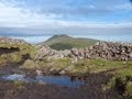
Seefin is the 746th highest place in Ireland. Seefin is the most southerly summit in the Galty Mountains area.
Linkback: https://mountainviews.ie/summit/629/
COMMENTS for Seefin (Suí Finn) 1 of 1  Follow this place's comments

|
|
|
|
||
| MountainViews.ie, a Hill-walking Website for the island of Ireland. 2400 Summiteers, 1480 Contributors, maintainer of lists: Arderins, Vandeleur-Lynams, Highest Hundred, County Highpoints etc | |||