Donation Request 2024

DONATE
Members and Supporters, the MountainViews Committee requests your help to meet the costs of the website and of other activities such as insured events or publications.
You do not have to be logged in to donate.
Features
Nearby features appear when you click the map.
Declutter tracks on map.
Place Search
Video
X
Pub: by
Galty Mountains Area , Cen: Central Galtys Subarea
Feature count in area: 24, by county: Tipperary: 18, Limerick: 8, of which 2 are in both Limerick and Tipperary, OSI/LPS Maps: 66, 74, EW-G
Highest Place: Galtymore 917.9m

Starting Places (19) in area Galty Mountains:
Aherlow House Hotel, Annaslinga, Attychraan Loop Trail, Cahirabbey Upper, Carrigeen, Clydagh Bridge, Combaun Woods CP, Combaun Woods Track, Galtyway Climb Black Rd, Glengarra Woods, Kilmoyler Railway Boreen, Kings Yard, Lake Muskry Trailhead, Lissantrelick Paradise Hill, Lisvernane, Pigeonrock Behanagh Rivers fork, Scaragh Reservoir, Scarragh Wood S, Scarragh Wood W

Summits & other features in area Galty Mountains:
Cen: Central Galtys: Cush 641.2m, Galtybeg 799.2m, Galtymore 917.9m, Greenane 801.3m, Greenane West 787m, Knockastakeen 581.6m, Knockeenatoung 601.3m, Lough Curra Mound 600.4m, Seefin 446.6m, Seefin North Top 444.1m
E: East Galtys: Laghtshanaquilla 629.4m, Laghtshanaquilla North-East Top 598m, Slieveanard 437.8m, Slieveanard NE Top 448.5m, Sturrakeen 541.7m
N: North Galtys: Slievenamuck 369m
W: West Galtys: Benard 479.5m, Carrignabinnia 822.9m, Knockaterriff 691.6m, Knockaterriff Beg 679.3m, Lyracappul 824.9m, Monabrack 630.1m, Slievecushnabinnia 774.8m, Temple Hill 783.1m

Note: this list of places may include island features such as summits, but not islands as such.
Rating graphic.
Lough Curra Mound, 600.4m Mountain Cnapán Loch an Churraigh A name in English,
Place Rating ..
, Knickeen, Black Hill, Tipperary County in Munster province, in Arderin Beg, Vandeleur-Lynam Lists, Lough Curra Mound is the 287th highest place in Ireland.
Grid Reference R86920 24213, OS 1:50k mapsheet 74
Place visited by: 249 members, recently by: jackos, Ansarlodge, Kirsty, derekfanning, Prem, Carolineswalsh, ConMack23, ToughSoles, Kaszmirek78, jollyrog, Moirabourke, Cunn2000, Krzysztof_K, therealcrow, markmjcampion
I visited this place: NO (You need to be a logged-in member for this.)
Longitude: -8.192759, Latitude: 52.369787, Easting: 186921, Northing: 124214, Prominence: 23m,  Isolation: 1km
ITM: 586873 624264
Bedrock type: Thick-bedded pale-red sandstone, (Galtymore Formation)
Notes on name: Lough Curra nestles in a crook of the Galtee ridge below Slievecushnabinnia. This knoll is situated just to the north-east of the Lough Curra. It is unnamed on Ordnance Survey maps. The form Cnapán Loch an Churraigh is provided here as a translation into Irish of "Lough Curra Mound/Lump", assuming that Curra represents an anglisation of Ir. currach, ‘marsh, bog’. It is not to be understood as an attested historical form.
  Short or GPS IDs, 6 char: LghCrM, 10 char: LghCrMnd

Linkback: https://mountainviews.ie/summit/277/
Gallery for Lough Curra Mound (Cnapán Loch an Churraigh) and surrounds
Summary for Lough Curra Mound (Cnapán Loch an Churraigh): A cheeky pudding below the Galty ridge
Summary created by Peter Walker 2013-04-06 21:25:31
            MountainViews.ie picture about Lough Curra Mound (Cnapán Loch an Churraigh)
Picture: Lough Curra Mtn from Lough Curra (Galtymore behind)
Lough Curra Mtn crouches at the foot of the cliffs that defend the north side of the Galty ridge through much of its length: as such an approach from the south would be logistically tricky. From the north park south of Clydagh Bridge at ( Clyda Brg (R874 278)) ('road unsuitable for vehicles' sign here) and take the right hand track into the woods. A couple of kilometres of waymarks lead to twin signposts pointing the way to either the Galtymore or Lough Curra stiles: the latter should be chosen. This leads to the edge of the trees, from where more waymarks and a decent path lead up to the lough. From here the outflow is crossed, and the facing short grassy slope leads to the unmarked top, an excellent spot for inspecting Galtymore's northern ramparts and for admiring the vast expanse of plain that the range overlooks.

The top is relatively easily included in the superb Cush - Slievecushnabinnia circuit by descending north from the latter until its eastern screes have been outflanked and a descending traverse can then be used to reach the lough.
Linkback: mountainviews.ie/summit/277/comment/5037/
Member Comments for Lough Curra Mound (Cnapán Loch an Churraigh)
Comment create / edit display placeholder

            MountainViews.ie picture about Lough Curra Mound (Cnapán Loch an Churraigh)
Picture: from the summit looking to Cush and Knockastakeen
jackill on Lough Curra Mound
by jackill 15 Mar 2010
I hadn't visited Lough Curra in I guess 4 years but today the dog, the wife and I were blessed with bright sunshine for a relaxing ramble to its summit. Towering buttresses of naked red sandstone rocks hanging above us, snow filled gullys leading the eye up to the rocky summit of Galtymore, two red dots of spidermen slowly ascending one.
Lough Curra and Lough Diheen are mentioned as being of note in
" Atlas and Cyclopedia of Ireland" (1900)By P. W. JOYCE
Mr Joyce also gives the following explanation of the original name for the Galtys which I hadn't come across before.
"The Galty Mountains were anciently called Crotta-Cliach or Slieve-Crot or Slieve-Grod, which name is still preserved in that of the old Castle of Dungrod, in the Glen of Aherlow, near Galbally.
Beside Cashel there were anciently three royal residences in Tipperary. One was Caher, the old name of which was Caher-Dun-Isga; the present castle, on the rock in the Suir, occupies the site of an old circular stone fort or caher, which was destroyed in the 3d century; and that caher was erected on the site of a still older dun or earthen fort. The second was Dun-Crot, which is now marked by the old castle of Dungrod (mentioned above), a comparatively modern edifice, built on the site of the old dun. The third was Knockgraffon, about 3 miles north of
Caher, which was the residence of Fiacha Mullehan, king of Munster in the 3d century. The remains of this old palace are still standing, consisting of a very fine high mound; it is celebrated in legend, and the surrounding parish still retains its name--Knockgraffon." Linkback: mountainviews.ie/summit/277/comment/4500/
Read Less
Read More

            MountainViews.ie picture about Lough Curra Mound (Cnapán Loch an Churraigh)
Spring sprung Lough Curra.
by dhmiriam 16 Mar 2011
Politics, recessionary gloom, folk yelling on mobile phones an elbow from your ear, as if the contraptions magically rendered everyone else invisible or audibly redundant , computer viruses, and melancholia, all perfectly sound reasons for seeking out an amphitheatre of hush, served with a bed of Alpine Rock Cress, and the aroma of fresh surround air. Brilliant early March sunshine melds into a fuzzy haze of children’s colouring-in. Greens, mauves, sand, silvers and gold, petrol stain the landscape. Would madam like a sprinkling of birdsong, an effervescence of bubble at her feet when the step is released, a whisper of wind in her hair, by the nape of her harried neck, or the taut skin pulsed by a pressing vein, and would she like it uninterruptedly served, and languidly drizzled over the course of the day? Yes, yes, and oh no matter how politically incorrect, YES! From Clydagh Bridge Clyda Brg (R87450 27780)
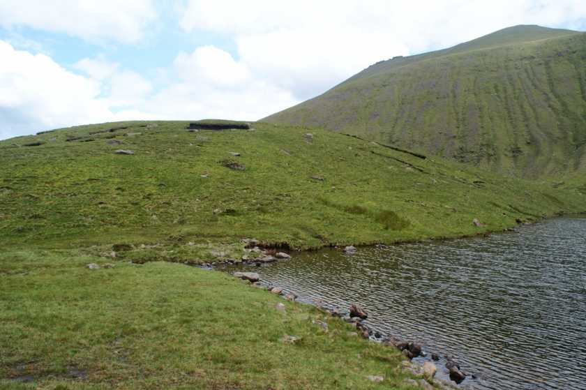
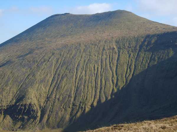
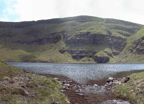
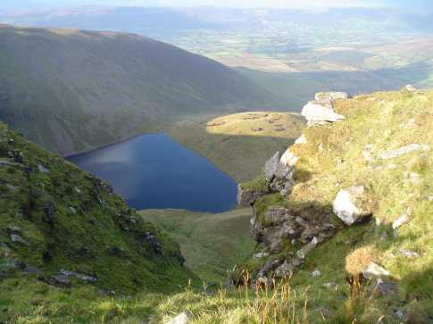
, along the right ( relevant) dirt track out of the car park, through wood, over style, across marshy pasture, up to the ‘ice road’ path, wafting its way ever upward to Lough Curra like a finger traversing a bountiful menu, and at last the splendid reveal of feast for the famished. A bowl of lake booms in its belly, having pigged out all morning on a vast blue sky and swallowed it whole. Frequently and inoffensively it burps, giggling at its edges, where the lower, naked slopes have plunged their extremities. On those slopes where the sun don’t dare peek, is a sugaring of frost unfazed by the festival beneath, inclining to complete indifference in their dark shades, too cool for their own good. Things jump in the lake. Indiscernible. Could be fish, could be joy. Facing the lake, and immediately behind us, stretched for the heavens, Lough Curra’s edges rouse, and so our route to Galtymore and Dawsons table. Linkback: mountainviews.ie/summit/277/comment/6277/
Read Less
Read More

jackill on Lough Curra Mound
by jackill 2 Apr 2010
Jimmy, I have seen one sign advising that dogs are unwelcome at one access point on the Aherlow side of Lough Curra. I did not access the lake/mountain by that route.Perhaps I should explain that I was brought up on and still live and work a farm in the foothills of the nearby Knockmealdowns. For upwards of 30 years we have kept sheep(dry cattle, suckler cows also).It is true to say uncontrolled dogs can chase sheep and indeed can attack and mutilate them in the very worst of cases( which I have experienced myself firsthand).If I was a farmer over whose lands groups of people /families regularly walked then I would think a blanket ban might be the easiest way to prevent harm to my sheep from those who don't know any better. However , rightly or wrongly I would like to think I don't fall into that category,at this time of year sheep are at particular risk from shock/stress due to the fact that they are probably pregnant.In my experience however the threat from dogs is no greater than that from humans. As long as the dogs are collared and not allowed to run after and worry the sheep then there is no danger, indeed the sheep are oblivious to them. Sheep are only injured if the dog actually bites them or chases them for a sustained period of time.My dog was collared at all times when near the sheep on that day and was not even let loose on the forestry track back to the carpark. I could take exception to the suggstion from someone who does not know me that I set out to injure animals, surely on mountainviews there can be a trust that contributors are not just mindless vandals? You must have read some of my comments before Jimmy, surely a line through the messaging service?
And as to Lough Curra Mountain, 1. What is its summit height compared to the lowest point on the col next to it? 2.What is the qualifying criteria for a summit on MV Linkback: mountainviews.ie/summit/277/comment/4568/
Read Less
Read More

            MountainViews.ie picture about Lough Curra Mound (Cnapán Loch an Churraigh)
simon3 on Lough Curra Mound
by simon3 10 Jun 2003
Lough Curra mountain sits beside Lough Curra. It and the cliffs above it have attracted a lot of attention. Robert Lloyd Praeger [The Way That I Went] draws attention to these cliffs (and the one above Lough Muskry, further east): “The alpine flora of the Galtees, which is fairly rich in comparison with that of other Irish mountain regions, is concentrated on these high cliff-ranges over the tarns. The rarest plant which occurs is the Alpine Rock Cress, of which a small colony was discovered by H.C. Hart about Lough Curra.”

Anyway the lakeside setting for the mountain is simply magnificent. I doubt many people visit the place in a year, certainly there are no tracks or signs of anyone passing. You could reach the place from the North starting near Clydagh Bridge (A (R874 281)). I got to it by descending from Slievecushnabinnia, a drop of some 200m. Choose a route off Slievecushnabinnia that veers well to the left of the lough to avoid cliffs Linkback: mountainviews.ie/summit/277/comment/536/
Read Less
Read More

            MountainViews.ie picture about Lough Curra Mound (Cnapán Loch an Churraigh)
jackill on Lough Curra Mound
by jackill 11 Oct 2004
Lough Curra and Lough Curra Mountain ( in the sunlight) from the ridge under Galtymore heading for Slievecushnabinnia. Linkback: mountainviews.ie/summit/277/comment/1236/
Read Less
Read More
EDIT Point of Interest
text
Videos
Recent Contributions
x
Conditions and Info
Use of MountainViews is governed by conditions and a privacy policy.
Read general information about the site.
Opinions in material here are not necessarily endorsed by MountainViews.
Hillwalking is a risk sport. Information in comments, walks, shared GPS tracks or about starting places may not be accurate for example as regards safety or access permission. You are responsible for your safety and your permission to walk.
See the credits and list definitions.

OSi logo
OSNI/LPS logo
Open Street Map
(Various variations used.)
British summit data courtesy:
Database of British & Irish Hills