Members and Supporters, the MountainViews Committee requests your help to meet the costs of the website and of other activities such as insured events or publications.
Feature count in area: 24, by county: Tipperary: 18, Limerick: 8, of which 2 are in both Limerick and Tipperary,
OSI/LPS Maps: 66, 74, EW-G
Highest Place: Galtymore 917.9m
Starting Places (19) in area Galty Mountains: Aherlow House Hotel, Annaslinga, Attychraan Loop Trail, Cahirabbey Upper, Carrigeen, Clydagh Bridge, Combaun Woods CP, Combaun Woods Track, Galtyway Climb Black Rd, Glengarra Woods, Kilmoyler Railway Boreen, Kings Yard, Lake Muskry Trailhead, Lissantrelick Paradise Hill, Lisvernane, Pigeonrock Behanagh Rivers fork, Scaragh Reservoir, Scarragh Wood S, Scarragh Wood W
Summits & other features in area Galty Mountains: Cen: Central Galtys: Cush 641.2m, Galtybeg 799.2m, Galtymore 917.9m, Greenane 801.3m, Greenane West 787m, Knockastakeen 581.6m, Knockeenatoung 601.3m, Lough Curra Mound 600.4m, Seefin 446.6m, Seefin North Top 444.1m E: East Galtys: Laghtshanaquilla 629.4m, Laghtshanaquilla North-East Top 598m, Slieveanard 437.8m, Slieveanard NE Top 448.5m, Sturrakeen 541.7m N: North Galtys: Slievenamuck 369m W: West Galtys: Benard 479.5m, Carrignabinnia 822.9m, Knockaterriff 691.6m, Knockaterriff Beg 679.3m, Lyracappul 824.9m, Monabrack 630.1m, Slievecushnabinnia 774.8m, Temple Hill 783.1m
Note: this list of places may include island features such as summits, but not
islands as such.
Knockeenatoung, 601.3mMountain Cnoicín na Teanga A name in Irish,
Place Rating ..
, Knockbaun, Tipperary County in Munster province, in Arderin, Vandeleur-Lynam Lists, Knockeenatoung is the 283rd highest place in Ireland.
Grid Reference R89484 21930,
OS 1:50k mapsheet 74 Place visited by: 275members, recently by: jackos, Petecal423, Leatra, knightsonhikes, markwallace, Prem, DeirdreM, ConMack23, Tuigamala, ToughSoles, jollyrog, Kaszmirek78, MichaelG55, Moirabourke, Cunn2000
I visited this place: NO (You need to be a logged-in member for this.)
Short or GPS IDs, 6 char: Kncknt, 10 char: Knckntng Linkback: https://mountainviews.ie/summit/272/
Gallery for Knockeenatoung (Cnoicín na Teanga) and surrounds
Summary
for Knockeenatoung (Cnoicín na Teanga):
TV or not TV
Summary created by simon3, liz50, jackill
2017-04-27 07:53:58
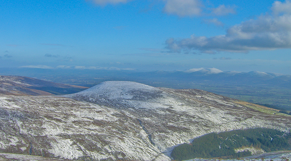
Picture: From Galtymore
The main carpark for access is at the start of The Black road Galtwy Rd (R89306 20345) (ht 333m)
The Black road is a rocky, easy to follow track that is usually used as a start to climbing Galtymore, and it winds gradually around the western flank of Knockeenatoung after you pass through the second gate.
Keeping to the right and ignoring the tracks leading to your left after an initial rise and a distance of about 2 kms the track flattens out for about 0.5kms and at this point Knockeenatoung is uphill on your right.
As the track sweeps around to your right before the uphill look out for the memorial stone to the 1976 air crash at A (R39348 22265)
From the stone go directly uphill through bog then heather to the summit, there is no track to follow.
The summit is crowned by a concrete hut which was used to transmit TV signals in the 1980s.
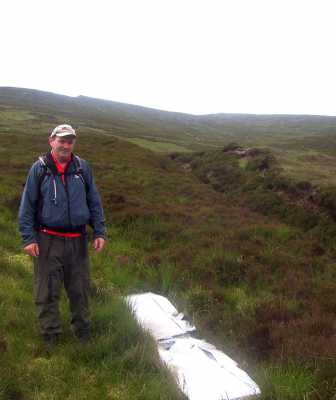
As a footnote to the memorial, I was coming down the ridge from O'Laughlins Castle towards Glengarra wood last month when I came across an old piece of aluminium which looked to my untrained eye to be part of an aeroplane tail. It is well embedded in the flora at B (R92080 22488) - 400 m elevation. From graffiti scratched on it it would appear to be there at least since the early 1980's. Is it connected? Linkback: mountainviews.ie/summit/272/comment/3306/
Read Less
Read More
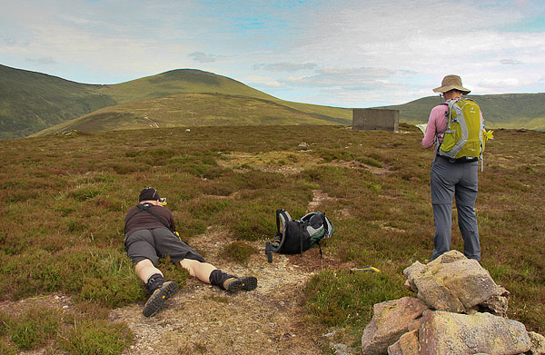
Picture: Did I or didn't I
Summiting a Vandeleur-Lynam, or er, not?
by simon3
23 Jul 2012
Old certainties like "safe as a bank" crumble, don't they? So it was with trepidation that I went with member jackill up Knockeenatoung. My plan was simple, reach the top of this place as a relatively easy Vandeleur-Lynam on what was scheduled to be a dry day in a wet summer. And I have mostly explored the Galtys from the north side, so this would be different.
But then I realised. The height marked for the place is 601m on the OS. A marginal case which on accurate measurement could easily turn out to be under 600 and therefore not a VL. Was the summit going to be demoted from the list or not? The last time I walked with jackill we went over Corrig in Wicklow and it turned out not to be an Arderin.
A measurement near the cairn with the precision differential GPS unit (accurate to 10 to 15cm) showed that the base of the cairn was less than 600m.
The picture show jackill using a small Victorian instrument known as an Abney level. It won't tell you your height but it will tell you whether another place is higher or lower. And it became apparent that the fairly recent cairn wasn't as high the land around the concrete hut. In fact the peat hag just behind and to the right of the concrete hut turns out to be over 600m.
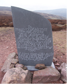
Memorial stone: Hi Colin, the stone is in memory of the three air men Tom Gannon, Jimmy Byrne and Dick O'Reilly. They were killed when their plane crashed not far from O'Loughlins Castle on the Galtees. The three were founding members of Abbyshrule Air Club. The crash took place on the 20th of September 1976. The crash site was located by an Air Corps helicopter, and the recovery of the three men was carried out by members of the Gardi, Army, Civil Defence, members from local hill walking clubs, and local people. This Crash led directly to the setting up of SEMRA "South Eastren Mountain Rescue Association" in 1977 see www.semra.ie for more history and info on the team.
The stone was erected by family members and friends (and permission was given by local landowners) on Saturday 28th October 2006, and unvaled on the 29th by three son's of the men. On the stone are lines from the poem "High Flight" by John Gillespie Magee a young pilot killed in WW2 "Oh, I have slipped the surley bonds of earth, Put out my hand and touched the face of God"
Regards, Jimmy Barry Linkback: mountainviews.ie/summit/272/comment/3061/
Read Less
Read More
Picture: Knockeenatoung Memorial Stone
Colin Murphy on Knockeenatoung
by Colin Murphy
22 Apr 2008
Pic shows a memorial stone just off Black Road immediately to the north of Knockeenatoung. The stone is in memory of Timmy Byrne, Tom Gannon and Dick O'Leary, who were members of the Abbeyshrule Aero Club, Longford and who died in the Galtys in 1976. I was curious to know more about this tragedy but my 'Googling' was unsuccessful. I presume these men died in a plane crash. Anyone know more? Linkback: mountainviews.ie/summit/272/comment/3057/
Read Less
Read More
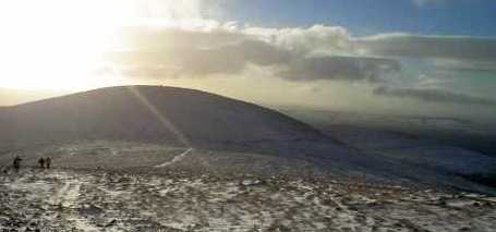
Picture: The White road
jackill on Knockeenatoung
by jackill
14 Nov 2005
Looking back down a rather white "Black road" at Christmas 2004.
Knockeenatoung is just left of centre with the concrete hut visible near the summit.
In the extreme left you can make out the slopes of Farbreaga and Crow Hill rising from the "Fhile Dearg" of the Knockmealdowns in the distance. Linkback: mountainviews.ie/summit/272/comment/1391/
Use of MountainViews is governed by conditions and a privacy policy.
Read general information about the site. Opinions in material here are not necessarily endorsed by MountainViews.
Hillwalking is a risk sport. Information in comments, walks, shared GPS tracks or about starting places may
not be accurate for example as regards safety or access permission. You are responsible for your safety and your permission to walk.
See the credits and list definitions.


 Our Facebook page.