Donation Request 2024

DONATE
Members and Supporters, the MountainViews Committee requests your help to meet the costs of the website and of other activities such as insured events or publications.
You do not have to be logged in to donate.
Features
Nearby features appear when you click the map.
Declutter tracks on map.
Place Search
Video
X
Pub: by
Galty Mountains Area , W: West Galtys Subarea
Feature count in area: 24, by county: Tipperary: 18, Limerick: 8, of which 2 are in both Limerick and Tipperary, OSI/LPS Maps: 66, 74, EW-G
Highest Place: Galtymore 917.9m

Starting Places (19) in area Galty Mountains:
Aherlow House Hotel, Annaslinga, Attychraan Loop Trail, Cahirabbey Upper, Carrigeen, Clydagh Bridge, Combaun Woods CP, Combaun Woods Track, Galtyway Climb Black Rd, Glengarra Woods, Kilmoyler Railway Boreen, Kings Yard, Lake Muskry Trailhead, Lissantrelick Paradise Hill, Lisvernane, Pigeonrock Behanagh Rivers fork, Scaragh Reservoir, Scarragh Wood S, Scarragh Wood W

Summits & other features in area Galty Mountains:
Cen: Central Galtys: Cush 641.2m, Galtybeg 799.2m, Galtymore 917.9m, Greenane 801.3m, Greenane West 787m, Knockastakeen 581.6m, Knockeenatoung 601.3m, Lough Curra Mound 600.4m, Seefin 446.6m, Seefin North Top 444.1m
E: East Galtys: Laghtshanaquilla 629.4m, Laghtshanaquilla North-East Top 598m, Slieveanard 437.8m, Slieveanard NE Top 448.5m, Sturrakeen 541.7m
N: North Galtys: Slievenamuck 369m
W: West Galtys: Benard 479.5m, Carrignabinnia 822.9m, Knockaterriff 691.6m, Knockaterriff Beg 679.3m, Lyracappul 824.9m, Monabrack 630.1m, Slievecushnabinnia 774.8m, Temple Hill 783.1m

Note: this list of places may include island features such as summits, but not islands as such.
Rating graphic.
Temple Hill, 783.1m Mountain Cnoc an Teampaill A name in Irish,
Place Rating ..
(Ir. Cnoc an Teampaill [OSI], 'hill of the church'), Teampuillín, Limerick County in Munster province, in Arderin, Vandeleur-Lynam, Irish Highest Hundred Lists, Temple Hill is the 56th highest place in Ireland. Temple Hill is the second most westerly summit in the Galty Mountains area.
Grid Reference R83334 21837, OS 1:50k mapsheet 74
Place visited by: 433 members, recently by: Ianhhill, kieran117, rhw, Paddym99, garybuz, MeabhTiernan, Deirdreb, orlaithfitz, BarnabyNutt, davidrenshaw, MarionP, Prem, Carolineswalsh, therealcrow, Blackstar
I visited this place: NO (You need to be a logged-in member for this.)
Longitude: -8.245297, Latitude: 52.348339, Easting: 183334, Northing: 121838, Prominence: 188.1m,  Isolation: 1.1km, Has trig pillar
ITM: 583287 621889
Bedrock type: Thick-bedded pale-red sandstone, (Galtymore Formation)

  Short or GPS IDs, 6 char: TmplHl, 10 char: Temple Hil

Linkback: https://mountainviews.ie/summit/54/
Gallery for Temple Hill (Cnoc an Teampaill) and surrounds
Summary for Temple Hill (Cnoc an Teampaill): Great views from conical hill on the western end of the Galtees ridge.
Summary created by markmjcampion, jackill, YoungJohn 2023-08-18 16:11:05
            MountainViews.ie picture about Temple Hill (<em>Cnoc an Teampaill</em>)
Picture: Temple Hill in the centre , from the south
Temple Hill is a distinct peak at the most westerly edge of the Galtees. It's a grassy hill with a scattering of rock and is usually firm underfoot. Views are widespread over the Galtees, Knockmealdowns, Ballyhouras as well as the flatter ground of S Tipp and N Cork.

SW. Park at ComBan Wd (R81980 18545), a forest entrance with room for 10 cars.
Walk up the forest track making your way after a few km to the start of a smaller track at A (R82736 20293). Follow this track, passing by a sheep pen and onto open hillside. Go uphill here to pick up a rough track at approximately B (R83300 20170). Follow this track to the ridge turning N when you reach it and then on to its end crossing a small rock field to the summit cairn. 4 hrs+ 12k return.

SE. Park at C (R86800 19700) and head for D (R86146 19943) via the route on track/2079. From here either head first for Knockaterriff Beg before heading WSW fro Temple Hill or take a more direct route for the summit of TH, hiking up the more western ridge from this point before veering NW and eventually picking up the ridge mentioned in the first route above. Return via Knockaterriff or Monabrack for a good loop walk.

W. Find somewhere to park near PardiseHl (R80498 21696) and follow track/3508 first to Paradise Hill and eventually out of the forest all the time following the western ridge until you veer NE for the summit close to the 700m contour line. [1.5h and 4k]

Other notable tracks include track/2295 4hrs+ 12k and track/2456 14k and 5h+
Linkback: mountainviews.ie/summit/54/comment/4814/
Member Comments for Temple Hill (Cnoc an Teampaill)
Comment create / edit display placeholder

            MountainViews.ie picture about Temple Hill (<em>Cnoc an Teampaill</em>)
Picture: Route from Temple Hill to Lyracappul
john_desmond on Temple Hill
by john_desmond 7 Apr 2005
Temple Hill is the most Westerly of the Galtee mtns. The picture shows to route off Temple Hill and on to Lyracappul. Be careful not to take the direct route. Keep on the high ground to the right to avoid some ravines. Not dangerous but you can lose a lot of height quickly. If it is misty, you might want to try going straight to Knockaterriff Beg (small 2 ft high metal post on its summit) and then onwards to Lyracappul. Linkback: mountainviews.ie/summit/54/comment/1633/
Read Less
Read More

            MountainViews.ie picture about Temple Hill (<em>Cnoc an Teampaill</em>)
jackill on Temple Hill
by jackill 7 Aug 2004
Climbed 22/02/04 - start woodland track ComBan Wd (R819 185) to track straight up side of hill at E (R833 202) - sharp turn left on track towards Temple Hill - the track goes further than shown on the map,when you run out of track a bearing of due north (useful in fog) will get you to the summit after approx 500 mtrs across a field of small rounded rocks - return by same route - 4 hrs & 12.5 kms
The photo was taken from the cairn on top of Temple hill (good shelter) with Galtys from Lyracappul on the left to Greenane on the right Linkback: mountainviews.ie/summit/54/comment/1056/
Read Less
Read More

            MountainViews.ie picture about Temple Hill (<em>Cnoc an Teampaill</em>)
Looking forward to the walk.
by simon3 3 Aug 2017
This picture was taken in 1998 during one of the Galty Walks from the summit of Temple Hill. The pointy hill left of centre on the skyline is Lyracappul, while the ground rising towards Lyracappul on the right are the Knockaterrifs, which is an area I can guarantee that you will rarely meet anyone on. Linkback: mountainviews.ie/summit/54/comment/1368/
Read Less
Read More

            MountainViews.ie picture about Temple Hill (<em>Cnoc an Teampaill</em>)
Picture: Marker for Temple Hill Log Book!
Log your visit!
by Harry Goodman 22 Jul 2011
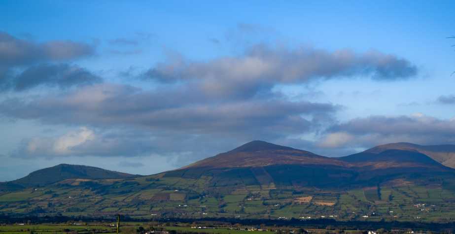
Climbed Temple Hill for the first time on Sunday 10.10.10 during a week-end walking in the Galtees. The walk was part of a circuit which also included Knockaterrif Beg, Lyracappul,Carrignabinnia and Monabrack (also climbed for the first time). Unfortunately the low mist experienced the previous day on a horseshoe walk around Glen Cush still persisted. We parked at C (R86800 19700) and having walked N along the access road for about 400m we followed a track going off to the left F (R86900 19900). This led along and then down through thick woodland, past an old ruined farm house and then SW, through three small fields, to a track G (R86100 19900) where we turned right (N) and followed it along to cross a bridge. We then walked in a westerly direction for about 1km, with the Pidgeonrock River on the left, before swinging N, still along the river, into the Pidgeonrock Glen. About 600m along H (R84500 21000) we crossed the river and headed steeply up to gain the crest of the Temple Hill ridge. Now in mist we headed NNW along the moorland top following a bearing for the summit some 900m further away. By chance (later rather than sooner!) we came across a good track heading for the summit, but not marked on our map, which eased our dreary trudge. This led to a large stony area which we crossed to the summit cairn and Trig Pillar 
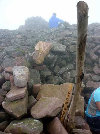
I (R83335 21830). Here we had ample room to settle in, out of the wind, for a short break. While on the summit we came across something unusual on an Irish hill, a piece of wood sticking up from a small pile of rocks with the the words "Sign Book" written on it (see photo). Under the rocks we found a tin box containing a book in which to write your name and date of climbing the mountain. We duly obliged and carefully replaced the tin for the next walker(s). From the top we headed down E with a touch of N to the coll 
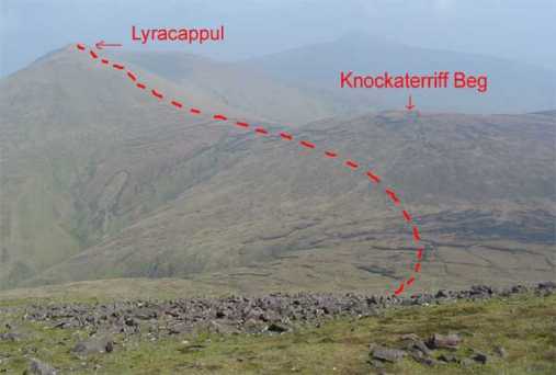
J (R83900 22000) before climbing Knockaterrif Beg the next hill on our circuit. Had we wished to return to the start we could have headed S down the Pidgeonrock Glen to pick up our approach route to Temple Hill. Linkback: mountainviews.ie/summit/54/comment/6409/
Read Less
Read More

Access from Castlequarter
by jimgraham 18 May 2012
Last week climbed Temple Hill round to Monabrack. Beware the route indicated by Paddy Dillon and the 1:50 000 map from Castlequarter - the last farmer before open land has made it as difficult as possible to go that way ! Enjoyed the walk though. Linkback: mountainviews.ie/summit/54/comment/6806/
Read Less
Read More
EDIT Point of Interest
text
Videos
Recent Contributions
x
Conditions and Info
Use of MountainViews is governed by conditions and a privacy policy.
Read general information about the site.
Opinions in material here are not necessarily endorsed by MountainViews.
Hillwalking is a risk sport. Information in comments, walks, shared GPS tracks or about starting places may not be accurate for example as regards safety or access permission. You are responsible for your safety and your permission to walk.
See the credits and list definitions.

OSi logo
OSNI/LPS logo
Open Street Map
(Various variations used.)
British summit data courtesy:
Database of British & Irish Hills