Members and Supporters, the MountainViews Committee requests your help to meet the costs of the website and of other activities such as insured events or publications.
Feature count in area: 24, by county: Tipperary: 18, Limerick: 8, of which 2 are in both Limerick and Tipperary,
OSI/LPS Maps: 66, 74, EW-G
Highest Place: Galtymore 917.9m
Starting Places (19) in area Galty Mountains: Aherlow House Hotel, Annaslinga, Attychraan Loop Trail, Cahirabbey Upper, Carrigeen, Clydagh Bridge, Combaun Woods CP, Combaun Woods Track, Galtyway Climb Black Rd, Glengarra Woods, Kilmoyler Railway Boreen, Kings Yard, Lake Muskry Trailhead, Lissantrelick Paradise Hill, Lisvernane, Pigeonrock Behanagh Rivers fork, Scaragh Reservoir, Scarragh Wood S, Scarragh Wood W
Summits & other features in area Galty Mountains: Cen: Central Galtys: Cush 641.2m, Galtybeg 799.2m, Galtymore 917.9m, Greenane 801.3m, Greenane West 787m, Knockastakeen 581.6m, Knockeenatoung 601.3m, Lough Curra Mound 600.4m, Seefin 446.6m, Seefin North Top 444.1m E: East Galtys: Laghtshanaquilla 629.4m, Laghtshanaquilla North-East Top 598m, Slieveanard 437.8m, Slieveanard NE Top 448.5m, Sturrakeen 541.7m N: North Galtys: Slievenamuck 369m W: West Galtys: Benard 479.5m, Carrignabinnia 822.9m, Knockaterriff 691.6m, Knockaterriff Beg 679.3m, Lyracappul 824.9m, Monabrack 630.1m, Slievecushnabinnia 774.8m, Temple Hill 783.1m
Note: this list of places may include island features such as summits, but not
islands as such.
Cush, 641.2mMountain Cois A name in Irish,
Place Rating ..
(Ir. Cois [OSI], 'side, flank'), Tipperary County in Munster province, in Arderin, Vandeleur-Lynam Lists, Cush is the 215th highest place in Ireland.
Grid Reference R89435 26200,
OS 1:50k mapsheet 74 Place visited by: 444members, recently by: kieran117, rhw, orlaithfitz, BarnabyNutt, Prem, Carolineswalsh, Tuigamala, Shaina, ToughSoles, FoxyxxxLoxy, Sonyalaw, Padraigin, Kaszmirek78, jollyrog, Moirabourke
I visited this place: NO (You need to be a logged-in member for this.)
Longitude: -8.155897, Latitude: 52.387694, Easting: 189436, Northing: 126200,
Prominence: 176.2m, Isolation: 2.1km ITM: 589387 626250 Bedrock type: Conglomerate & purple sandstone, (Slievenamuck Conglomerate Formation) Notes on name: The name may well be a shortened form of Cois na Binne, which appears in several place-names in this area. This mountain is referred to as Binnia in 'The Mountains of Ireland' by Paddy Dillon.
Short or GPS IDs, 6 char: Cush, 10 char: Cush Linkback: https://mountainviews.ie/summit/215/
Gallery for Cush (Cois) and surrounds
Summary
for Cush (Cois):
A gheal mo Chroi
Summary created by jackill
2011-06-11 07:58:49
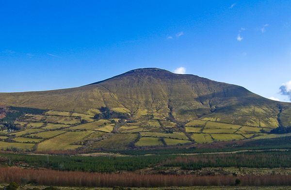
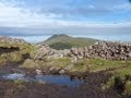
Picture: Cush from the road to Lough Curra
The usual way to get to the summit is to park at Clydagh bridge forest entrance Clyda Brg (R87450 27780) ht137m, where there is parking on both sides of the road. Walk up the tarred road to a stile, A (R87796 27461) ht189m(note: no dogs sign here), cross the stile and walk the rough track near the forest edge before crossing a wire fence via stile, B (R88590 27213) ht358m and then on to the summit.
The summit (no cairn or marker)is a fantastic viewpoint for the glacier ravaged north face of the Galty range.
Many would use this as a start point for a fine circuit of Clydagh continuing on to Galtybeg,Galtymore and Slievecushnabinnia.
Cush can also be climbed from the directiion of Knockastakeen using Galty Waterworks as an access track, there are options to park on the road or in the small carpark(where you can also walk to Lough Muskry) at C (R91547 28065).
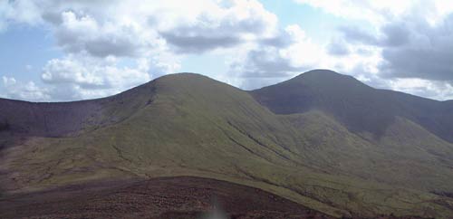
Cush is the most northerly of the mountains in the Galtee range. As a viewing platform it affords great views of the northern, cliffy faces of Galtymore, Galtybeg and Greenane. (As usual in Ireland, it is the north facing side of the 500m mountains which have had the most wear from glacial action.) Our photo shows the summits of Galtybeg (left of centre) and Galtymore (to right). Beneath and to the left of Galtybeg is the corrie that contains Borheen Lough. To the right of Galtybeg you can just make out the lip of Lough Diheen, a little jewel in the side of the Galtees at 554m altitude. Linkback: mountainviews.ie/summit/215/comment/532/
Read Less
Read More
Picture: Summit of Cush with Galtymore Behind
murphysw on Cush
by murphysw
19 Dec 2005
I did this last Monday on a crystal clear winters day. I followed the directions for the Cush-Galtybeg-Galtymore-Slievecushnabinnia horseshoe as given in Lonely Planet’s Walking in Ireland. I parked at the car park near the Clydagh River bridge at D (R875 278). Here you find a notice describing the history and geography of the Galtees and a welcome, if you don’t be smiling, from local landowners and the Glen of Aherlow failte society. But do note that dogs are prohibited. Ignore the two forest paths that lead from the car park and walk up the tarmac road for a few hundred yards until you see concrete steps on your left. Cross these, then cross a stile, then follow a rough path and fence up the side of Cush, until you reach a fence barring your way. There is a stile about 20 yards to your right to cross this, leaving you on open ground all the way to the summit. The ground is pleasant enough underfoot, but it is quite steep. All the way up great views are afforded of the Glen of Aherlow to your back. The summit has no cairn or pillar but has a very sharp drop off its western side which would need to be watched in bad visibility. The summit has two distinct peaks, the northernmost being the highest. After this it was off to tackle Galtybeg. Linkback: mountainviews.ie/summit/215/comment/2097/
Read Less
Read More
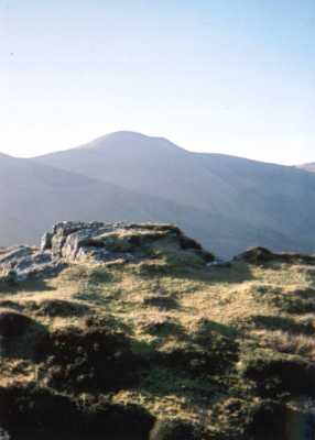
Picture: Western face of Cush
tony_limerick on Cush
by tony_limerick
14 Aug 2005
Climbed Cush as part of a horseshoe walk taking in Galtybeg and Galtymore having started by turning off at Clydah brige(Ref E (R875 280) OS sheet # 74) and parking the car at the first junction with forest tracks heading off to the left and right. The views towards the steep Northern face of the Galtees are well worth the climb although it is possible to skip Cush on this circuit by heading straight for the col between it and Galtybeg. Had one of those experiences that make it all worth while when dense cloud on the summit of Galymore cleared to grant me a few minutes of magnificent views while sipping my coffee !
The full circuit can be quite strenuous so allow between 5 and 6 hours to complete. Linkback: mountainviews.ie/summit/215/comment/1889/
Read Less
Read More
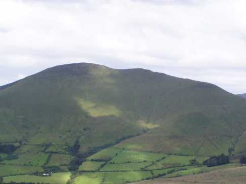
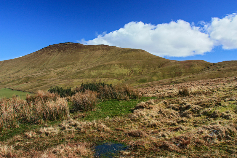
Picture: The gradual ridge to Cush
Pictured from the SW
by simon3
26 Mar 2018
Cush pictured from the South West (updated 2018). Cush is surrounded by forestry to its west, south and east however to the north (right of this picture) is a long col to Galtybeg. Linkback: mountainviews.ie/summit/215/comment/533/
Read Less
Read More
petelunn on Cush
by petelunn
1 Jun 2004
A great short and steep climb of just under a hour on the way to Galtybeg and Galtymore, with superb views of both. We set off from Clydagh Bridge. The footpath, a left turn just a few hundred yards up the road, is partially blocked by gorse but recognisable by the "No Dogs" sign. The partial shelter offered from a South or Westerly wind by the larger ridge is welcome on a blowy day. Linkback: mountainviews.ie/summit/215/comment/979/
Use of MountainViews is governed by conditions and a privacy policy.
Read general information about the site. Opinions in material here are not necessarily endorsed by MountainViews.
Hillwalking is a risk sport. Information in comments, walks, shared GPS tracks or about starting places may
not be accurate for example as regards safety or access permission. You are responsible for your safety and your permission to walk.
See the credits and list definitions.


 Our Facebook page.