Members and Supporters, the MountainViews Committee requests your help to meet the costs of the website and of other activities such as insured events or publications.
Feature count in area: 24, by county: Tipperary: 18, Limerick: 8, of which 2 are in both Limerick and Tipperary,
OSI/LPS Maps: 66, 74, EW-G
Highest Place: Galtymore 917.9m
Starting Places (19) in area Galty Mountains: Aherlow House Hotel, Annaslinga, Attychraan Loop Trail, Cahirabbey Upper, Carrigeen, Clydagh Bridge, Combaun Woods CP, Combaun Woods Track, Galtyway Climb Black Rd, Glengarra Woods, Kilmoyler Railway Boreen, Kings Yard, Lake Muskry Trailhead, Lissantrelick Paradise Hill, Lisvernane, Pigeonrock Behanagh Rivers fork, Scaragh Reservoir, Scarragh Wood S, Scarragh Wood W
Summits & other features in area Galty Mountains: Cen: Central Galtys: Cush 641.2m, Galtybeg 799.2m, Galtymore 917.9m, Greenane 801.3m, Greenane West 787m, Knockastakeen 581.6m, Knockeenatoung 601.3m, Lough Curra Mound 600.4m, Seefin 446.6m, Seefin North Top 444.1m E: East Galtys: Laghtshanaquilla 629.4m, Laghtshanaquilla North-East Top 598m, Slieveanard 437.8m, Slieveanard NE Top 448.5m, Sturrakeen 541.7m N: North Galtys: Slievenamuck 369m W: West Galtys: Benard 479.5m, Carrignabinnia 822.9m, Knockaterriff 691.6m, Knockaterriff Beg 679.3m, Lyracappul 824.9m, Monabrack 630.1m, Slievecushnabinnia 774.8m, Temple Hill 783.1m
Note: this list of places may include island features such as summits, but not
islands as such.
Knockaterriff Beg, 679.3mMountain Cnoc an Tairbh Beag A name in Irish,
Place Rating ..
(prob. Ir. Cnoc an Tairbh Beag [PDT], 'little hill of the bull'), Little Bull Hill, Cruach a' Tarbh Beag, Limerick County in Munster province, in Arderin Beg, Vandeleur-Lynam Lists, Knockaterriff Beg is the 145th highest place in Ireland.
Grid Reference R84377 22175,
OS 1:50k mapsheet 74 Place visited by: 270members, recently by: rhw, Prem, Carolineswalsh, therealcrow, SeanPurcell, marymac, Tuigamala, NualaB, ToughSoles, jollyrog, Moirabourke, Cunn2000, Ansarlodge, Beti13, westside
I visited this place: NO (You need to be a logged-in member for this.)
Short or GPS IDs, 6 char: KnckBg, 10 char: KncktrfBeg Linkback: https://mountainviews.ie/summit/141/
Gallery for Knockaterriff Beg (Cnoc an Tairbh Beag) and surrounds
Summary
for Knockaterriff Beg (Cnoc an Tairbh Beag):
Follow the Blackrock valley
Summary created by jackill
2010-07-28 15:15:08
One way to climb this mountain is by taking the second road to your left on the Dublin side of Kilbeheny where there is a signpost marked "Galtycastle".
Follow this minor road uphill ignoring the turn-off to the right (also signposted Galtycastle) and taking the left hand fork up a cul de sac at the Y junction after it.
After travelling a further 2 kms on this tarred road you will come to a locked gate. Parking here is very tight for even one car on the roadside.
Walk through the gate and over a small concrete bridge to the left. Follow a rough track past a shed and up the Blackrock river valley to its end.Then walk north east uphill to the col between Lyracappul and Knockaterriff Beg and from there to the summit.
The summit is marked by a small cairn.
You have the option to cross the bog for a short distance to gain the summit of Knockaterriff.
Descent from Knockaterriffs summit to the south is possible , however it is steep and slippery so care is needed.
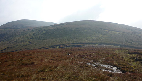
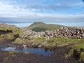
Picture: Looking back to Knockaterrif Beg from the S slope of Lyracappul
A memorable yet nondescript hill!
by Harry Goodman
21 Jul 2011
Climbed Knockaterrif Beg on 10 10 10 as part of a circuit which also included Temple Hill, Lyracappul, Carrignabinnia and Monabrack (For the first part of the walk see my comments on Temple Hill). From the coll below Temple Hill A (R83900 22000) we walked NE up the short but peat hagged and boggy climb to the flat topped and nondescript top of the hill with little to commend it as a climb other than "it is there" and on the MV list of 600m mountains. Indeed, as others have also written, I suspect any walkers who frequent these hills will, on their way from Temple Hill to Lyracappul, simply by-pass it. In addition I would doubt if anyone would consider climbing Knockaterrif Beg as a sole objective for a day in the hills. However for those of us there on 10 10 10 this top B (C84384 22163) proved to be a magical place!! Why, you may well ask! Heavy mist had plagued us for the previous day and a half when suddenly, brightness shone all around! Within fifteen minutes we were making our way down N from the hill to the coll below Lyracappul C (R84300 22400) and then up to the top enveloped in warm sunshine with ever increasing views of the surrounding mountains. For our small group this nondescript hill will live long in our memory. Linkback: mountainviews.ie/summit/141/comment/6418/
Read Less
Read More
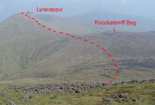
Picture: View of Knockaterriff Beg from Temple Hill
john_desmond on Knockaterriff Beg
by john_desmond
3 Apr 2005
As can be seen from the photo, Knockaterriff Beg is just a piece of high ground on the ridge that goes South to Knockaterriff itself. The photo shows the usual path from Temple Hill to Lyracappul. Most people dont bother with Knockaterriff Beg and just skirt around the side of it as it is shorter. No distinctive features on it other than a small metal post about 2 foot high near the top. The cairn that is shown to the North-West of the summit in OS No.74 is most likely a mistake and probably should be shown just to the North-West of Knockaterriff itself. Linkback: mountainviews.ie/summit/141/comment/1617/
Read Less
Read More
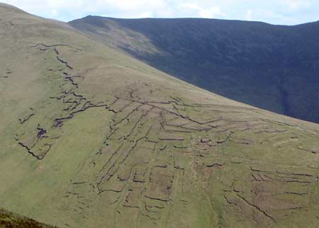
Picture: High level peat cutting on Knockaterriff Beg
simon3 on Knockaterriff Beg
by simon3
17 Nov 2005
Knockaterriff Beg has no clear top, though there were one or two of what looked like broken poles on it. From the general top area you can get this intriguing view of the ridge extending SE from Carrignabinnia. It is like a broken green mosaic. It was formed by old peat workings. Linkback: mountainviews.ie/summit/141/comment/542/
Read Less
Read More
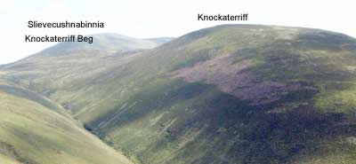
simon3 on Knockaterriff Beg
by simon3
15 Jun 2003
The relationship between the small Knockterriff Beg and the larger mountains around it should be clear from this picture, taken from the southeastern spur of Temple Hill. Linkback: mountainviews.ie/summit/141/comment/548/
Read Less
Read More
oldsoldier on Knockaterriff Beg
by oldsoldier
11 Feb 2009
I Climbed knockaterriff and knockaterriff beg today as I had to bag these as part of my 600 meter peaks in 2009. I approached from the Pigeonrock glen. The road in is becoming very broken and will be soon unusable for cars. I walked in along the Pigeonrock glen from the sheep shed at the end of the road. The ridge of Temple hill was on my left for a long walk until I turned right and went straight to the summit. it should be noted that there are two cairns on the summit of knockaterriff. As I approached up form Pigeonrock glen I came across one but according to my GPS it was in the wrong place, after searching about for five minutes or so I came across the real summit. In fog it might be a hazard. Galty Mór looked resplendant in the distance. On my descent I released an ewe that was caught in the wire fence. She had caught her hoof between two strands of wire. She was very quiet and allowed me to release her without as much as a whimper. She limped off slowly, hope she will be ok. Linkback: mountainviews.ie/summit/141/comment/3589/
Use of MountainViews is governed by conditions and a privacy policy.
Read general information about the site. Opinions in material here are not necessarily endorsed by MountainViews.
Hillwalking is a risk sport. Information in comments, walks, shared GPS tracks or about starting places may
not be accurate for example as regards safety or access permission. You are responsible for your safety and your permission to walk.
See the credits and list definitions.


 Our Facebook page.