Cookies. This website uses cookies, which are small text files that the website puts on your computer to facilitate operation. Cookies help us provide a better service to you. They are used to track general user traffic information and to help the website function properly.

Click to hide this notice for 30 days.
Welcome to MountainViews
If you want to use the website often please enrol (quick and free) at top right.
Overview
Detail
Zoom: ??
For more map options click on any overview map area or any detail map feature.
Find Suggested Walks
Find hill, mountain, island, coastal feature.
Videos
Recent Contributions
Get Notifications

Cooneen Hill: Ok hill, top-notch view.

A long, meandering route to Ballykildea

Cooneen Hill: Briars, pines and pain

Kilcommon from the west

Ballykildea Mountain: A walk in the woods

Ballykildea Mountain: A long approach from the north

Easy walk, with nice views towards Eagle Island

Muckish: Muckish for the Summits On The Air (SOTA)

Glan Mountain: A Glan rocker......

Typical wet North Mayo Coastal Hill

Sea Hill: Surprisingly good sea views from this hill

Beenbane: Borreen to heaven

Conditions and Info
Use of MountainViews is governed by conditions and a privacy policy.
Read general information about the site.
Opinions in material here are not necessarily endorsed by MountainViews.
Hillwalking is a risk sport. Information in comments, walks, shared GPS tracks or about starting places may not be accurate for example as regards safety or access permission. You are responsible for your safety and your permission to walk.
See the credits and list definitions.
Video display
Galty Mountains Area   Cen: Central Galtys Subarea
Place count in area: 24, OSI/LPS Maps: 66, 74, EW-G 
Highest place:
Galtymore, 917.9m
Maximum height for area: 917.9 metres,     Maximum prominence for area: 820 metres,

Note: this list of places includes island features such as summits, but not islands as such.
Rating graphic.
Knockastakeen Mountain Cnoc an Stáicín A name in Irish (Ir. Cnoc an Stáicín [OSI], 'hill of the little stack') Tipperary County in Munster Province, in Arderin List, Conglomerate & purple sandstone Bedrock

Height: 581.6m OS 1:50k Mapsheet: 74 Grid Reference: R91526 25790
Place visited by 178 members. Recently by: jimmel567, johncusack, JohnRea, eflanaga, Jimmy600leavey, LiamG1951, abptraining, TippHiker, a3642278, Jana, DNicholson, Hillwalker65, annem, PrzemekPanczyk, jackos
I have visited this place: NO (You need to be a logged-in member to change this.)

Longitude: -8.12519, Latitude: 52.384043 , Easting: 191526, Northing: 125790 Prominence: 78m,  Isolation: 1.8km
ITM: 591477 625840,   GPS IDs, 6 char: Knc582, 10 char: Knckstkn
Bedrock type: Conglomerate & purple sandstone, (Slievenamuck Conglomerate Formation)

Ir. stáca can be a stack of hay or corn. The name appears to refer to the hill's shape.   Knockastakeen is the 333rd highest place in Ireland.

Linkback: https://mountainviews.ie/summit/307/
COMMENTS for Knockastakeen (Cnoc an Stáicín) 1 2 Next page >>  
Follow this place's comments
MountainViews.ie Picture about mountain Knockastakeen (<i>Cnoc an Stáicín</i>) in area Galty Mountains, Ireland
Picture: Knockastakeen from the Lough Muskry track.
 
A real eye-opener for appreciating the Galty Mountains.
Short Summary created by Harry Goodman  21 Jul 2011
Park at R9200028300 starA and follow the track going off to the left past a metal barrier and information panel. Continue up through all junctions to a stile. Cross over and follow the track up the now open hillside, ignoring any branches off to the left, At the crest, just as the track starts to descend, turn right (W) and go up the heather covered slope to the crest of the ridge and a small but distinct path. Turn left (SW) and follow along to the top C9150025800 starB. Drop down to the right and then around the front of the small but sheer rocky escarpment before descending SE to pick up the Lough Muskry track. Turn left and follow back to the start. On a clear day the visual rewards from the top of this hill, reached with minimal effort, are magnificent. If time allows a walk out and back to the Lough is recommended. All within a 7.5km walk. Linkback: https://mountainviews.ie/summit/307/comment/5067/
 
MountainViews.ie Picture about mountain Knockastakeen (<i>Cnoc an Stáicín</i>) in area Galty Mountains, Ireland
Picture: Knockastakeen from Greenane
A great vantage point
by wicklore  29 May 2010
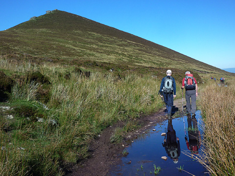
Using Map 78, I found my way to the entrance of the Galty Waterworks and parked at R91547 28065 starC at a line of boulders at the entrance. Going through the boulders I followed the much overgrown remains of an access road south. It became necessary to walk atop the grassy ridge next to the road/track in places, as prickly thorn bushes crowded in to block progress. Passing through the worst of this, I followed the track to a gate at
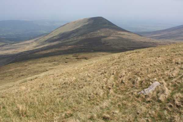
 R91483 27393 starD. By now views had opened up of the valley and mountains ahead, with Cush to the right, and Galtybeg in the distance.

After passing through the gate onto open bog Knockastakeen looms on the left. The forestry that had been present ceased after the gate. I turned left uphill and handrailed the forest which brought me over the northern tip of the Knockastakeen ridge. After about 400 metres I turned right and followed the ridge south. About 1.5 kms brought me to the summit of Knockastakeen at
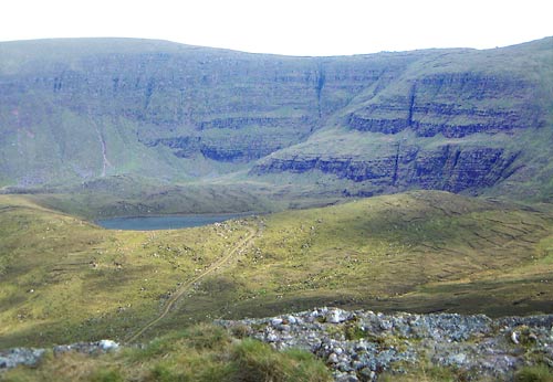
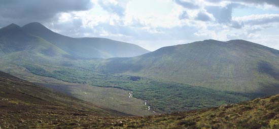
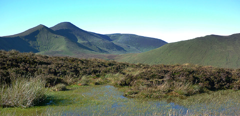
 R91517 25824 starE. Amazing views were had of Galtymore, Galtybeg, Lough Muskry and its backdrop of cliffs leading up to Greenane ahead. Cush sits just across the narrow valley to the right and sat high and proud over the forestry on its lower slopes.

This route is straightforward and leads to the top of Knockastakeen in under 1 ½ hours. As an outlier it affords views of the Galtys not possible from anywhere else but Cush. Therefore it is well worth the visit. While I continued on to the main Galty ridge, it would be easy to drop down (steeply) to the valley floor to the west and follow the forest edge back to the gate and on to the starting point. Linkback: https://mountainviews.ie/summit/307/comment/5836/
Your Score: Very useful <<  >>Average
 
MountainViews.ie Picture about mountain Knockastakeen (<i>Cnoc an Stáicín</i>) in area Galty Mountains, Ireland
 
simon3 on Knockastakeen, 2003
by simon3  22 Jun 2003
From the summit there is a clear view of Lough Muskry. This nestles under Greenane.
HC Hart [Climbing in the British Isles 1895] was much impressed by Lough Muskry, waxing lyrical and valedictory “.. Still grander, however, are the cliffs above Lough Muskry. These tower to a height of about 1,200 ft in great terraces and vegetated walls above the north and north-east ends of the lake. .. Should the climber get pounded here (as not seldom happens) let him beware of undue haste. A mouthful of food here has a wonderful effect in steadying the nerves.” Linkback: https://mountainviews.ie/summit/307/comment/560/
Your Score: Very useful <<  >>Average
 
MountainViews.ie Picture about mountain Knockastakeen (<i>Cnoc an Stáicín</i>) in area Galty Mountains, Ireland
simon3 on Knockastakeen, 2003
by simon3  22 Jun 2003
On the way up Knockastakeen from its SE side I got this view of the steep north facing side of the Galtees. From the left, the skyline peaks are first Galtybeg and then Galtymore. To the right is Cush. Linkback: https://mountainviews.ie/summit/307/comment/562/
Your Score: Very useful <<  >>Average
 
MountainViews.ie Picture about mountain Knockastakeen (<i>Cnoc an Stáicín</i>) in area Galty Mountains, Ireland
Picture: Galtybeg, Galtymore, Slievecushnabinnia and Cush from Knockastakeen
 
A must on any walk out to Lough Muskry
by Harry Goodman  22 Jul 2011
Climbed Knockastakeen on 11 Oct 2010 as part of a walk out to Lough Muskry on a beautiful still and sunny day. We parked at R9200028300 starA in a cleared parking area just off the road. As this was the third day of our walking week-end we wanted a shorter walk than those on the previous two days in order to be back at the car and heading for home by early afternoon. We therefore choose the Lough Muskry waymarked walk which starts in Rossadrehid Village but opted to save 2km of road walking each way by parking at R9200028300 starA. From the car park we went left past a barrier and information panel and followed the forest track up, through all junctions, to a stile. Once over the stile the path became much more stony and uneven. We followed it up the open hillside ignoring any off shoots to the left and at its crest, just as it started to descend, we turned right up on to the heather covered moorland to gain the grassy ridge of Knockastakeen and a small but distinct path where we turned left and followed it along to the top of the hill R9150025800 starF. For relatively little effort we found ourselves being treated to one of the best panoramas seen on our week-end walking in the Galtees. Of particular interest was the very fine view we had of Cush, Galtybeg, Galtymore and Slievecushnabinnia, tops climbed two days earlier but not seen, or really enjoyed, due to very high winds and a heavy blanket of mist. The rocky top was a good vantage point for Lough Muskry and the cliff wall backdrop below Greenane. On descending from the top to go to Lough Muskry we headed down to the right and then around the face of the hill's steep, rocky, but small, escarpment, before going SE down to the track. A right turn soon brought us to Lough Muskry where we had a very pleasing break before returning by the track to the car park, a walk of some 7.5 km. Linkback: https://mountainviews.ie/summit/307/comment/6417/
Your Score: Very useful <<  >>Average
 
MountainViews.ie Picture about mountain Knockastakeen (<i>Cnoc an Stáicín</i>) in area Galty Mountains, Ireland
mneary34 on Knockastakeen, 2004
by mneary34  26 Oct 2004
On 23/10/04 we traversed from Cush to Knockastakeen and headed for an opening in the forest where a stream flows at point 905264 starG. Instead of the small opening we expected there was a gap in the forest approx. 80 metres wide. In the valley between the two mountains we came across this stream which after previous days rain was in full flow. The climb of 240 metres height gain to Knockastakeen is stiff. Linkback: https://mountainviews.ie/summit/307/comment/1280/
Your Score: Very useful <<  >>Average
 
COMMENTS for Knockastakeen (Cnoc an Stáicín) 1 2 Next page >>
(End of comment section for Knockastakeen (Cnoc an Stáicín).)

OSi logo OSNI/LPS logo
Some mapping:
Open Street Map
(Various variations used.)
British summit data courtesy:
Database of British & Irish Hills
(Creative Commons Licence)
MountainViews.ie, a Hill-walking Website for the island of Ireland. 2300 Summiteers, 1460 Contributors, Newsletter since 2007