Members and Supporters, the MountainViews Committee requests your help to meet the costs of the website and of other activities such as insured events or publications.
Feature count in area: 24, by county: Tipperary: 18, Limerick: 8, of which 2 are in both Limerick and Tipperary,
OSI/LPS Maps: 66, 74, EW-G
Highest Place: Galtymore 917.9m
Starting Places (19) in area Galty Mountains: Aherlow House Hotel, Annaslinga, Attychraan Loop Trail, Cahirabbey Upper, Carrigeen, Clydagh Bridge, Combaun Woods CP, Combaun Woods Track, Galtyway Climb Black Rd, Glengarra Woods, Kilmoyler Railway Boreen, Kings Yard, Lake Muskry Trailhead, Lissantrelick Paradise Hill, Lisvernane, Pigeonrock Behanagh Rivers fork, Scaragh Reservoir, Scarragh Wood S, Scarragh Wood W
Summits & other features in area Galty Mountains: Cen: Central Galtys: Cush 641.2m, Galtybeg 799.2m, Galtymore 917.9m, Greenane 801.3m, Greenane West 787m, Knockastakeen 581.6m, Knockeenatoung 601.3m, Lough Curra Mound 600.4m, Seefin 446.6m, Seefin North Top 444.1m E: East Galtys: Laghtshanaquilla 629.4m, Laghtshanaquilla North-East Top 598m, Slieveanard 437.8m, Slieveanard NE Top 448.5m, Sturrakeen 541.7m N: North Galtys: Slievenamuck 369m W: West Galtys: Benard 479.5m, Carrignabinnia 822.9m, Knockaterriff 691.6m, Knockaterriff Beg 679.3m, Lyracappul 824.9m, Monabrack 630.1m, Slievecushnabinnia 774.8m, Temple Hill 783.1m
Note: this list of places may include island features such as summits, but not
islands as such.
Greenane West, 787.0mMountain An Grianán (mullach thiar) A name in Irish,
Place Rating ..
For origin of name, see Greenane., Cnoc na gCapall, Tipperary County in Munster province, in Arderin, Vandeleur-Lynam Lists, Greenane West is the 54th highest place in Ireland.
Grid Reference R91253 23991,
OS 1:50k mapsheet 74 Place visited by: 387members, recently by: kieran117, rhw, MartMc, BarnabyNutt, davidrenshaw, Prem, Carolineswalsh, SeanPurcell, Tuigamala, Padraigin, ToughSoles, muddypaws, Nailer1967, jollyrog, Moirabourke
I visited this place: NO (You need to be a logged-in member for this.)
Short or GPS IDs, 6 char: GrnnWs, 10 char: GrnnWest Linkback: https://mountainviews.ie/summit/53/
Gallery for Greenane West (An Grianán (mullach thiar)) and surrounds
Summary
for Greenane West (An Grianán (mullach thiar)):
The broad back of the Galtys.
Summary created by jackill
2012-01-25 20:29:16
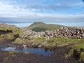
Picture: Greenane West from Greenane
This summit can be accessed starting from The Black road carpark Galtwy Rd (R89306 20345) (ht333m)
The Black road is a rocky, easy to follow track that is usually used as a start to climbing Galtymore, and it winds gradually around the western flank of Knockeenatoung and up towards Galtybeg.
When you reach a large cairn under Galtybeg at a 'Y' in the track go straight ahead, the track ends after 300 meters in a large rocky area. On the west side of this area look for a faint track heading towards Galtybeg and follow it as far as you can.
It is best to keep to the west and get on the lower slopes of Galtybeg before turning east for Greenane west as this allows you to avoid the worst of the peat hags.
As you gain the lower slopes of Galtybeg turn west heading for A (R89476 24164), the col over Bohreen lough, and then up hill in 2 large steps and across a broad,boggy plateau to the summit.
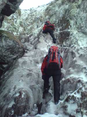
Reached 786m from the north side of the Galtees. Walk began below waterworks at Rossadrehid B (R920 283). Heading via forest tracks to gate and style onto Open Mountain at C (R928 267). At this point you have two options either straight up the valley via the white posts (marking the route of the water main) or stick to the service track for Lough Muskry. In bad weather the track is probably best advisable as underfoot conditions can be somewhat damp. As you approach Muskry keep to you right and about 10m above lakeshore. Head for unnamed lake at rear of Muskry. Once you have arrived here you can begin to gain height by entering the gully to the right as you look up (on the map most right stream entering small lake). I have been in this particular gully on a few occasions and it always amazes me at how much this gully has changed. Best conditions I ever seen it was 19 march 2007 (as seen in picture) where there was some nice ice scrambling. Once reached high ground O Loughlins castle is a nice lunch stop and then onto 786. Once the high point has been bagged the option for the return route is head for the col between 786m and Gatlybeg above Lough Boreen. There is a sheep track around the back of the Lough from the col which will bring you out at D (R897 247). This is a very handy track and it offers nice vice of the lake below. From here it’s a short walk to the forest corner and from there it’s a damp slog via the tree line to the forest track at E (R908 257). And from here its forest tracks to the cars.
Unfortunately I cannot be credited with the excellent photo, as that’s me leading. So pk well done on the excellent picture Linkback: mountainviews.ie/summit/53/comment/2677/
Read Less
Read More
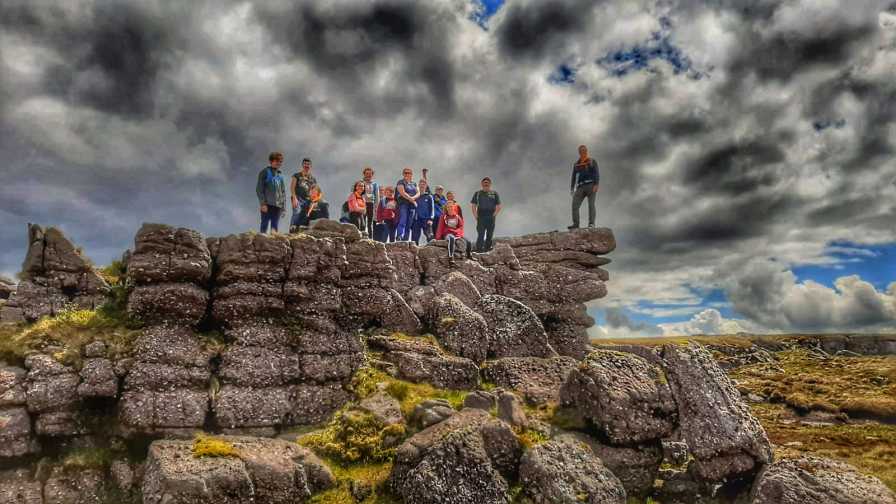
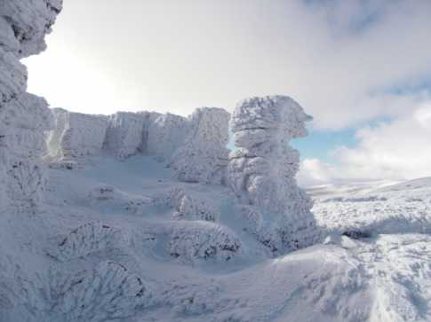
Picture: On the Battlements.
Where's the castle?
by jackill
5 Jul 2019
I've spent a lot of time over the years contributing to MountainViews but in the last few years I've slowly cut back the addiction and replaced it with helping out in the local scout group in Fermoy.
For the scout group it means they get dragged up mountains at least once a month.
This photo was taken on our end of year hike last month which took in Galtybeg and Greenane.
Unfortunately I had sold it as a hillwalk to O'Loughlins Castle.
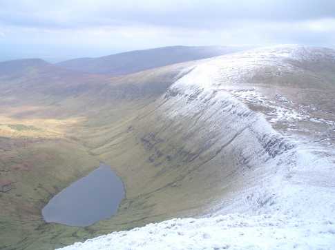
Coming down the western slopes of Galty beg with the teardrop of Borheen Lough below. In front is the col before the climb up to the summit of Greenane West on the right of the photo(if you can find it). On the left is Knockastakeen and in the distance the other Greenanes towering above Lough Musky.Some Sundays it is worth getting out of bed. Linkback: mountainviews.ie/summit/53/comment/1526/
Read Less
Read More
jackill on Greenane West
by jackill
7 Aug 2004
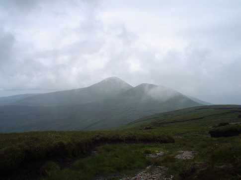
Picture taken on Greenane west - hard to decide where 786 m was but this looked about right.
Started the walk on Black Road (Galtwy Rd (R893 204))to its end ,right hand fork under Galtybeg, then across the bog ( bearing 45 deg) to F (R897 242) overlooking Borheen Lough, then on to O'Loughlins castle and Greenane - return by same route. 14 kms -4.5 hours Linkback: mountainviews.ie/summit/53/comment/1060/
Read Less
Read More
Picture: Looking into the icy castle - no shelter in there!
Use of MountainViews is governed by conditions and a privacy policy.
Read general information about the site. Opinions in material here are not necessarily endorsed by MountainViews.
Hillwalking is a risk sport. Information in comments, walks, shared GPS tracks or about starting places may
not be accurate for example as regards safety or access permission. You are responsible for your safety and your permission to walk.
See the credits and list definitions.


 Our Facebook page.