Members and Supporters, the MountainViews Committee requests your help to meet the costs of the website and of other activities such as insured events or publications.
Feature count in area: 24, by county: Tipperary: 18, Limerick: 8, of which 2 are in both Limerick and Tipperary,
OSI/LPS Maps: 66, 74, EW-G
Highest Place: Galtymore 917.9m
Starting Places (19) in area Galty Mountains: Aherlow House Hotel, Annaslinga, Attychraan Loop Trail, Cahirabbey Upper, Carrigeen, Clydagh Bridge, Combaun Woods CP, Combaun Woods Track, Galtyway Climb Black Rd, Glengarra Woods, Kilmoyler Railway Boreen, Kings Yard, Lake Muskry Trailhead, Lissantrelick Paradise Hill, Lisvernane, Pigeonrock Behanagh Rivers fork, Scaragh Reservoir, Scarragh Wood S, Scarragh Wood W
Summits & other features in area Galty Mountains: Cen: Central Galtys: Cush 641.2m, Galtybeg 799.2m, Galtymore 917.9m, Greenane 801.3m, Greenane West 787m, Knockastakeen 581.6m, Knockeenatoung 601.3m, Lough Curra Mound 600.4m, Seefin 446.6m, Seefin North Top 444.1m E: East Galtys: Laghtshanaquilla 629.4m, Laghtshanaquilla North-East Top 598m, Slieveanard 437.8m, Slieveanard NE Top 448.5m, Sturrakeen 541.7m N: North Galtys: Slievenamuck 369m W: West Galtys: Benard 479.5m, Carrignabinnia 822.9m, Knockaterriff 691.6m, Knockaterriff Beg 679.3m, Lyracappul 824.9m, Monabrack 630.1m, Slievecushnabinnia 774.8m, Temple Hill 783.1m
Note: this list of places may include island features such as summits, but not
islands as such.
Greenane, 801.3mMountain An Grianán A name in Irish,
Place Rating ..
(Ir. An Grianán [OSI], 'sunny spot'), Tipperary County in Munster province, in Arderin, Vandeleur-Lynam, Irish Highest Hundred Lists, Greenane is the 40th highest place in Ireland. Greenane is the second highest point in county Tipperary.
Grid Reference R92506 23936,
OS 1:50k mapsheet 74 Place visited by: 449members, recently by: kieran117, rhw, Paddym99, Sophie-Hayes, MartMc, Deirdreb, BarnabyNutt, davidrenshaw, Prem, Carolineswalsh, Tuigamala, ToughSoles, muddypaws, jollyrog, Nailer1967
I visited this place: NO (You need to be a logged-in member for this.)
Short or GPS IDs, 6 char: Grnn, 10 char: Greenane Linkback: https://mountainviews.ie/summit/39/
Gallery for Greenane (An Grianán) and surrounds
Summary
for Greenane (An Grianán):
Flat-topped central Galty at the head of a fine, steep-backed corry.
Summary created by markmjcampion, jackill
2023-08-18 16:09:43
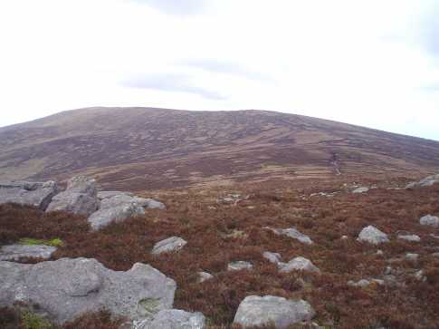
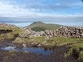
Picture: Greenane from the west
Greenane is a grassy, rocky plateau to the E of Galtymore. It overlooks the Glen of Aherlow and, closer, Lough Muskry and its corry to the N. Further afield are extensive views of the Knockmealdowns and Comeraghs. V steep ground to the N should command respect in all weather.
N. Park at forest entrance near Rosadrehid at LkMuskry (R91744 28241). Follow forest track S for 2k before coming to a gate at A (R92408 26675) that leads out onto open mountain. Once a suitable point is found to cross the river, climb the spur to Farbreega. From here follow the ridge to Greenane. 2hrs+ This can be done as part of a horseshoe…see track/1587
SW. Start from carpark at Galtwy Rd (R89306 20345) and follow the Black road, a rocky, easy-to-follow track that winds around the W flank of Knockeenatoung and up towards Galtybeg. When you reach a large cairn at a 'Y' in the track go straight ahead and aim for B (R89703 24136), the col over Bohreen Lough, and then uphill and across a broad boggy plateau to the summit of Greenane W. Continue E dropping slightly by the rocky tor of O'Loughlins castle after which you will need to wind gingerly through v wet bog before the final ascent to the summit trig of Greenane. 2.5 hrs+
S. Park at C (R92426 19821)and head N through the forest. Aim to clear the forest in the vicinity of D (R92476 22043), head up E to gain the SSE ridge of G and make your way steeply to the summit. 2 hrs
Notable tracks incl track/1587, track/2796 and the long linear route over the eastern Galtees.track/2303
This is a looped walk of Lough Muskry starting at a forest park entrance a few kilometers from Rosadrehid at LkMuskry (R91744 28241). Follow the forest track South for 2km before coming to a gate at A (R92408 26675) that leads out onto the Galtees. Once a suitable point is found to cross the river, climb the spur to Farbreega. From here it's a ridge walk around to Greenane, onto the unusual rock formations known as O'Loughlins Castle then on to Greenane West before descending to Lough Muskry. From here it's easy to follow the river North back to the gate at the forest trail, 2km along this leads back to the start point. Linkback: mountainviews.ie/summit/39/comment/20120/
Read Less
Read More
sinbadw on Greenane
by sinbadw
5 Aug 2004
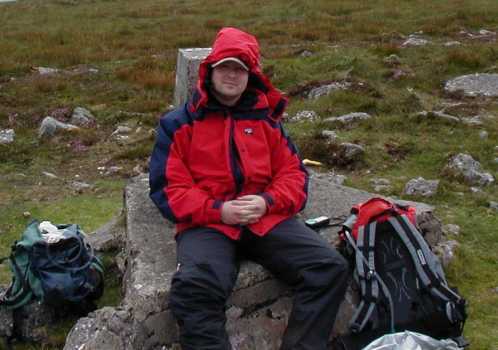
The third peak on our hike, greenane is a bit of a legend fom my youth. My grandfather lived at the Cahir end of the Galtees and always wanted to walk over to lough Muskry, in the correy of Greenane. My grandmother would never let him go alone (very sensible) so I was parceled off with him. Unfortunately being about 10 my stamina was not up to the task and we never made it. I have since made the trip a couple of times including a somewhat insane scramble up a stream on the back wall of the correy. My grandfather and I made it to the lake on another occasion, coming up from the glen of Aherlow. Here is a shot of me sitting beside the triangulation point nursing a pair of blisters. Linkback: mountainviews.ie/summit/39/comment/1048/
Read Less
Read More
jackill on Greenane
by jackill
23 Jan 2009
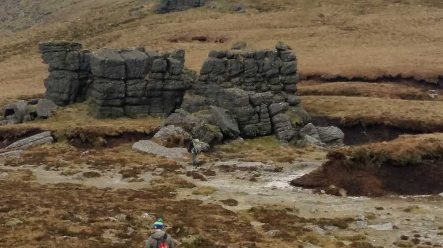
From the summit of Greenane West looking back at the turf banks on the western side of Greenane. The summit of Greenane is on the extreme left of photo. Linkback: mountainviews.ie/summit/39/comment/1525/
Read Less
Read More
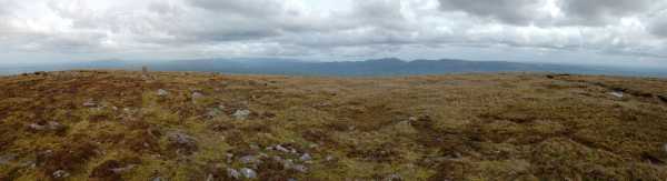
Picture: Looking towards the Knockmealdown Mountains about 16km away. [9 May 2009]
etrino on Greenane
by etrino
7 Jan 2010
Walking along the Galtee ridge makes a change from just going up Galtymore and back, although the flat top of Greenane isn't very distinctive. We had planned to descend into Glengarra Wood, but had to skirt around it because the Garda were there investigating a dead body. Linkback: mountainviews.ie/summit/39/comment/4340/
Use of MountainViews is governed by conditions and a privacy policy.
Read general information about the site. Opinions in material here are not necessarily endorsed by MountainViews.
Hillwalking is a risk sport. Information in comments, walks, shared GPS tracks or about starting places may
not be accurate for example as regards safety or access permission. You are responsible for your safety and your permission to walk.
See the credits and list definitions.


 Our Facebook page.