Donation Request 2024
You do not have to be logged in to donate.
DONATE
Members and Supporters, the MountainViews Committee requests your help to meet the costs of the website and of other activities such as insured events or publications.You do not have to be logged in to donate.
Welcome to MountainViews
If you want to use the website often please enrol (quick and free) at top right.
If you want to use the website often please enrol (quick and free) at top right.
Overview

For more map options click on any overview map area or any detail map feature.
Detail Map Features
Showing 6 items:
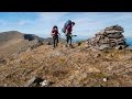
Brandon 951.7m, Brandon Peak 840m, Gearhane 803m, Brandon South Top 790m,
4947, 12km
2241, 8km
Brandon 951.7m, Brandon Peak 840m, Gearhane 803m, Brandon South Top 790m,
Tracks:
Find Suggested Walks
Find hill, mountain, island, coastal feature.
Videos


Recent Contributions
 Get Notifications
Get Notifications
Crocknapeast: Long walk up windfarm roads.
 Collaborative entry
Double bag mostly on windfarm tracks.
 Colin Murphy
Mulnanaff: Longish walk up windfarm road.
 Collaborative entry
Good, relatively easy double bag
 Colin Murphy
Binbane NE Top: Simple bag from its neighbouring top.
 Collaborative entry
Binbane: Steepish approach to relatively easy Carn.
 Collaborative entry
Lake District: Dale Head Horseshoe
Crucknaree: Magnificent views!
 paddyhillsbagger
Lake District: Coledale Horseshoe
Dunranhill: Sika deer and sitka spruce
 hibby
hibby
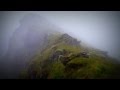
Crocknasharragh: Impressive views on initial ascent.
 Colin Murphy
Longish walk to isolated top
 Colin Murphy
Conditions and Info
Use of MountainViews is governed by conditions and a privacy policy.
Read general information about the site.
Opinions in material here are not necessarily endorsed by MountainViews.
Hillwalking is a risk sport. Information in comments, walks, shared GPS tracks or about starting places may not be accurate for example as regards safety or access permission. You are responsible for your safety and your permission to walk.
See the credits and list definitions.
 Visit our Facebook page.
Video display
Brandon Group
Area S: Brandon Ridge South Subarea
Place count in area: 15,
OSI/LPS Maps: 70, EW-DC, EW-DW
Highest place: Brandon, 951.7m
Maximum height for area: 951.7 metres,
Maximum prominence for area: 934 metres,
Places in area Brandon Group:
Cen: Faha Ridge:Benagh 822.5mFaha Ridge 809.2m
N: Brandon Point:Faill an tSáis 430.7m
N: Brandon Ridge North:Brandon Far North Top 840.1mBrandon North Top 895.4mMasatiompan 761.9mPierasmore North Top 700mPierasmore 745.7m
S: Ballysitteragh:An Bhinn Dubh 479.2mBallysitteragh 623mBeennabrack 608.5m
S: Brandon Ridge South:Gearhane 803mBrandon Peak 840mBrandon 951.7mBrandon South Top 790m
Note: this list of places includes island features such as summits, but not islands as such.
Highest place:
Brandon, 951.7mPlaces in area Brandon Group:
Cen: Faha Ridge:
Benagh 822.5mFaha Ridge 809.2mN: Brandon Point:
Faill an tSáis 430.7mN: Brandon Ridge North:
Brandon Far North Top 840.1mBrandon North Top 895.4mMasatiompan 761.9mPierasmore North Top 700mPierasmore 745.7mS: Ballysitteragh:
An Bhinn Dubh 479.2mBallysitteragh 623mBeennabrack 608.5mS: Brandon Ridge South:
Gearhane 803mBrandon Peak 840mBrandon 951.7mBrandon South Top 790mNote: this list of places includes island features such as summits, but not islands as such.

Bedrock type: Rhythmically bedded sandstone, (Ballymore Sandstone Formation)
The name refers to the peak's pointed profile when seen from the S. Note its relationship with its higher neighbour, Brandon Peak, which is Barr an Ghéaráin, 'top of the fang' in Irish. An Géarán is the 38th highest place in Ireland.
Linkback: https://mountainviews.ie/summit/37/
COMMENTS for Gearhane (An Géarán) 1 2 Next page >>  Follow this place's comments

|
|
|
|
||
| MountainViews.ie, a Hill-walking Website for the island of Ireland. 2400 Summiteers, 1480 Contributors, maintainer of lists: Arderins, Vandeleur-Lynams, Highest Hundred, County Highpoints etc | |||