This website uses cookies, which are small text files that the website puts on your device to facilitate operation. Cookies help us provide a better service to you. They are used to track general user traffic information and to help the website function properly.
Feature count in area: 15, all in Kerry,
OSI/LPS Maps: 70, EW-DC, EW-DW
Highest Place: Brandon 951.7m
Starting Places (18) in area Brandon Group: Ballinloghig, Ballybrack Mid, Brandon Pilgrimage Trail, Brandon Point, Brandon Village, Cloghane Community Centre, Conor Pass, Coosavuddig Quay Brandon Creek, Faha Grotto, Feoghanagh River, Hostel Cloghane Village, Lough Camclaun, Lough Doon CP, Mullaghveal Farm, Pedlars Lodge, Pilgrimage Trail Owenmore River, Sauce Creek Walkway Dingle Way, Tiduff
Summits & other features in area Brandon Group: Cen: Faha Ridge: Benagh 822.5m, Faha Ridge 809.2m N: Brandon Point: Faill an tSáis 430.7m N: Brandon Ridge North: Brandon Far North Top 840.1m, Brandon North Top 895.4m, Masatiompan 761.9m, Pierasmore North Top 700m, Pierasmore 745.7m S: Ballysitteragh: An Bhinn Dubh 479.2m, Ballysitteragh 623m, Beennabrack 608.5m S: Brandon Ridge South: Gearhane 803m, Brandon Peak 840m, Brandon 951.7m, Brandon South Top 790m
Note: this list of places may include island features such as summits, but not
islands as such.
Brandon North Top, 895.4mMountain Cnoc Bréanainn (mullach thuaidh) A name in Irish,
Place Rating ..
For origin of name, see Cnoc Bréanainn / Brandon., Sliabh a' Choimín, Kerry County in Munster province, in Arderin Beg, Vandeleur-Lynam Lists, Cnoc Bréanainn (mullach thuaidh) is the second highest mountain in the Brandon Group area and the 15th highest in Ireland.
Grid Reference Q46109 12541,
OS 1:50k mapsheet 70 Place visited by: 385members, recently by: Ansarlodge, westside, Aidan_Ennis, discovering_dann, bowler, Arcticaurora, RosieMc, DeirdreM, farmerjoe1, jackos, marymac, maryblewitt, Marykerry, Dee68, agakilbride
I visited this place: NO (You need to be a logged-in member for this.)
Longitude: -10.253787, Latitude: 52.243534, Easting: 46109, Northing: 112541,
Prominence: 23.3m, Isolation: 0.4km ITM: 446093 612594 Bedrock type: Rhythmically bedded sandstone, (Ballymore Sandstone Formation) Notes on name: Climbers who follow the Faha Ridge and stick to the crest will eventually emerge on the summit ridge near the grassy top of this peak. In clear conditions it commands a spectacular view of the Faha Ridge.
Short or GPS IDs, 6 char: BrndNr, 10 char: BrndnNrthT Linkback: https://mountainviews.ie/summit/15/
Gallery for Brandon North Top (Cnoc Bréanainn (mullach thuaidh)) and surrounds
Summary
for Brandon North Top (Cnoc Bréanainn (mullach thuaidh)):
A corrected summit position
Summary created by Peter Walker, jackill
17 Mar, 2016
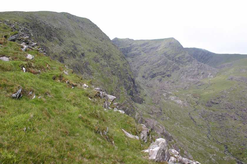
Picture: Brandon N Top from the Faha Ridge
The most scenic route to the summit of Brandon North, the Pilgrim's path, starts at the carpark under the Faha Grotto( (Q493 119)) on the hillside overlooking Cloghane. There is room for 8-10 cars.
Walk up the clear path past the grotto and on until you cross over a wire fence. At this point you will be near the crest of the ridge. Continue on the well marked lower path which will lead you around into the valley under the Faha ridge overlooking the Paternoster lakes.
At the top of this valley ,cross the stream, you will see a rocky, eroded, track leading up at the left-hand side, onto the col from where you turn right and walk approx 750 mtrs to the summit of Brandon.
The summit was surveyed in 2012 and it was determined the highest point is at the coordinates given here and not at spot height 891 as marked on the 1:50000 OS map.
Add a Place Comment for Brandon North Top, Cnoc Bréanainn (mullach thuaidh) (15) in Area: Brandon Group, N: Brandon Ridge North, County: Kerry, N: Brandon Ridge North
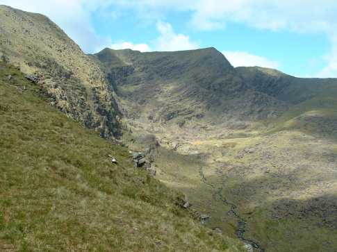
I strayed to the right of the broad ridge ascending Brandon East Top from Faha to view the Owannafeana valley and Brandon North Top. My main objective in doing this was to assess a possible descent route. I intended to follow the main ridge north to Masatiompan, from which I could either descend east (a very roundabout route to Faha) or rescend the north top and return through the corrie (also fairly demanding). However, my study revealed that a descent from point A (Q463 134) to the Owannafeana river, following that down and finally recrossing the Faha ridge low down should present no difficulties. It didn't, apart from a few wet areas. Finally, I tried to make use of grassy ramps to cross the ridge too soon: it is best to stay low until there are no more rock bands, and you should then attain the ridge directly above Faha. Linkback: mountainviews.ie/summit/15/comment/1756/
Read Less
Read More
jackill on Brandon North Top
by jackill
21 Aug 2004
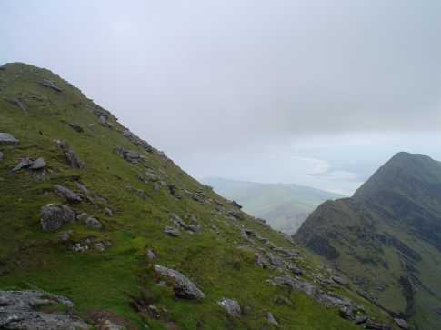
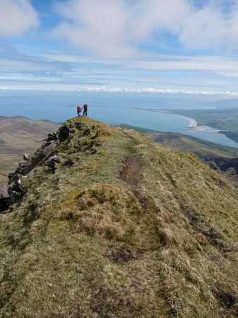
Picture of Brandon North Top (right of photo) with point 809m (left of photo) looking out onto Brandon Bay - if you're climbing Mount Brandon from Cloghane and up behind Locha Coim an Cnoic take a few minutes (10) and a short detour to climb this peak , its well worth the effort for the views. Linkback: mountainviews.ie/summit/15/comment/1100/
Read Less
Read More
GWPR on Brandon North Top
by GWPR
11 Dec 2002
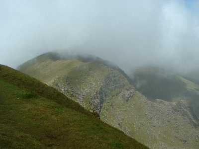
Spectacular walk along the ridge above Coimin na gCnamh. When the mist rolls back to reveal the ridge it's a memorable scene! Linkback: mountainviews.ie/summit/15/comment/242/
Read Less
Read More
skyehigh on Brandon North Top
by skyehigh
12 Jun 2005
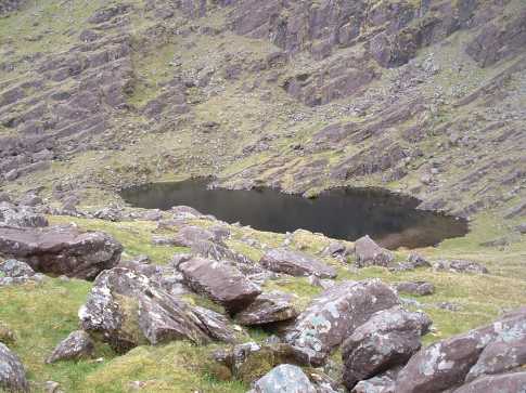
The secluded An Loch Dubh, nestling below the northern cliffs of Brandon North Top, passed (and admired) on a descent from Pierasmore to the Owannafeana river. Linkback: mountainviews.ie/summit/15/comment/1757/
Use of MountainViews is governed by conditions and a privacy policy.
Read general information about the site. Opinions in material here are not necessarily endorsed by MountainViews.
Hillwalking is a risk sport. Information in comments, walks, shared GPS tracks or about starting places may
not be accurate for example as regards safety or access permission. You are responsible for your safety and your permission to walk.
See the credits and list definitions.


 Add a Place Comment for Brandon North Top, Cnoc Bréanainn (mullach thuaidh)


 Our Facebook page.