Members and Supporters, the MountainViews Committee requests your help to meet the costs of the website and of other activities such as insured events or publications.
Feature count in area: 15, all in Kerry,
OSI/LPS Maps: 70, EW-DC, EW-DW
Highest Place: Brandon 951.7m
Starting Places (18) in area Brandon Group: Ballinloghig, Ballybrack Mid, Brandon Pilgrimage Trail, Brandon Point, Brandon Village, Cloghane Community Centre, Conor Pass, Coosavuddig Quay Brandon Creek, Faha, Feoghanagh River, Hostel Cloghane Village, Lough Camclaun, Lough Doon CP, Mullaghveal Farm, Pedlars Lodge, Pilgrimage Trail Owenmore River, Sauce Creek Walkway Dingle Way, Tiduff
Summits & other features in area Brandon Group: Cen: Faha Ridge: Benagh 822.5m, Faha Ridge 809.2m N: Brandon Point: Faill an tSáis 430.7m N: Brandon Ridge North: Brandon Far North Top 840.1m, Brandon North Top 895.4m, Masatiompan 761.9m, Pierasmore North Top 700m, Pierasmore 745.7m S: Ballysitteragh: An Bhinn Dubh 479.2m, Ballysitteragh 623m, Beennabrack 608.5m S: Brandon Ridge South: Gearhane 803m, Brandon Peak 840m, Brandon 951.7m, Brandon South Top 790m
Note: this list of places may include island features such as summits, but not
islands as such.
Masatiompan, 761.9mMountain Más an Tiompáin A name in Irish,
Place Rating ..
(Ir. Más an Tiompáin [OSI], 'rump of the drum/hump/hollow'), Kerry County in Munster province, in Arderin, Vandeleur-Lynam, Irish Best Hundred, Irish Highest Hundred Lists, Más an Tiompáin is the 69th highest place in Ireland. Más an Tiompáin is the second most northerly summit in the Brandon Group area.
Grid Reference Q46535 14547,
OS 1:50k mapsheet 70 Place visited by: 277members, recently by: rhw, Deirdreb, markwallace, maoris, Carolineswalsh, ToughSoles, Jai-mckinney, Carolyn105, Beti13, Paddym99, bagoff, garybuz, chelman7, NualaB, Krzysztof_K
I visited this place: NO (You need to be a logged-in member for this.)
Longitude: -10.248472, Latitude: 52.261663, Easting: 46535, Northing: 114547,
Prominence: 109.1m, Isolation: 0.7km ITM: 446518 614599 Bedrock type: Conglomerate, sandstone & siltstone, (Pointagare Group) Notes on name: Tiompán can also mean a deep sheltered cove. Nearby there is such a cove at Sauce Creek.
Short or GPS IDs, 6 char: Mstmpn, 10 char: Mstmpn Linkback: https://mountainviews.ie/summit/66/
Gallery for Masatiompan (Más an Tiompáin) and surrounds
Summary
for Masatiompan (Más an Tiompáin):
Remote, coastal peak with conical summit and superb views.
Summary created by markmjcampion, scapania
2023-08-18 16:23:03
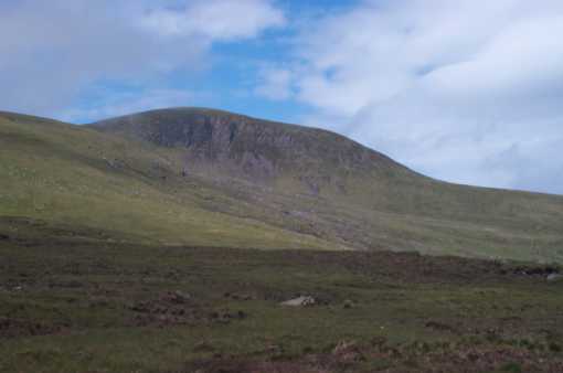
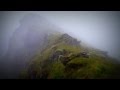
Picture: Masatiompan from the NE ridge
Masatiompan is the most N peak on the splendid ridge that runs north from the Conor Pass. A close neighbour of Brandon it is surrounded by cliffs and v steep ground on its N flanks. Great views of local hills and the rugged coast.
W. Park in Tiduff (A (Q43300 12496)) and take the Dingle Way E, following the old track to the col between M and Piaras Mór. This track climbs gradually to a shoulder at 450m, from where a steep drop to the Atlantic far below is revealed. Continue to the col with its ogham stone, then go left following a fence to the summit cairn. Allow 3.5 hrs+ for this 8.5k return with 650m ascent.
W. It's also possible to start at Brandon Creek CusVud Qy (Q42305 12028) and hug the coast on a narrow trail above spectacular cliffs to Beennaman before heading up M's steep western spur. 2.5 hrs to summit.
E. Park carefully at the end of the R550 near Bran Pt (Q52621 17262). From here cross a stile and follow a track that will carry you past Bookeen's southern col and on up past Faill an tSáis before joining the Dingle Way at B (Q49132 14544). Follow the DW vaguely W until you reach the col at C (Q46484 14118) and then walk N for 500m to the summit. 3hrs+ to summit
A more scenic, rugged and undulating route that stays closer to the coastline can be started at the same point and skirts the north of Bookeen before joining the previous route at D (Q49753 15632).
The Dingle Way route can also be accessed from Brandon village or by parking at Sauce Ck (Q50825 14584)
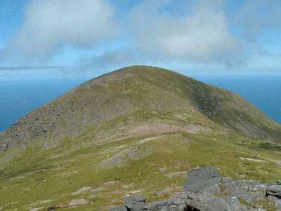
This is a view of Masatiompan from the SE. I approached it, starting from the village of Cloghane, by crossing the Faha Ridge at its lower eastern end and heading straight for the mountain across the wide expanse of grassland of Macha an Mhíl. The Dingle Way, coming from Ballycurrane, skirts the steep cliffs visible in the photo, before turning E towards Brandon village and eventually Cloghane. Linkback: mountainviews.ie/summit/66/comment/2742/
Read Less
Read More
padodes on Masatiompan
by padodes
18 Jun 2007
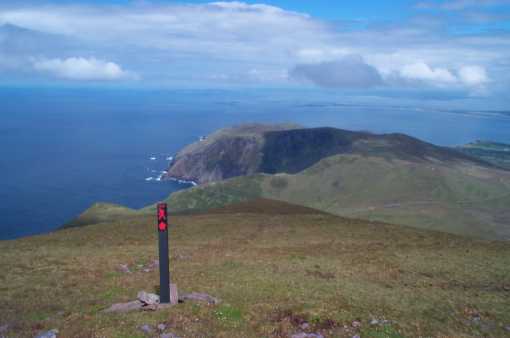
This photo is taken descending the NE ridge of Masatiompan and provides a view of Sauce Creek directly ahead. A straightforward climb from the saddle between Piaras Mór and Masatiompan takes one quickly to the broad top, but this soon narrows to a tight ridge as you descend NE. I have no idea what walk the waymarker is meant to indicate, unless it is simply an extension of the Dingle Way. Perhaps it is just intended as a pointer to the fog-bound, steering them towards the NE ridge and away from the cliffs to each side. Linkback: mountainviews.ie/summit/66/comment/2743/
Read Less
Read More
Picture: Masatiompan via NE ridge this way
dbloke on Masatiompan
by dbloke
15 Sep 2008
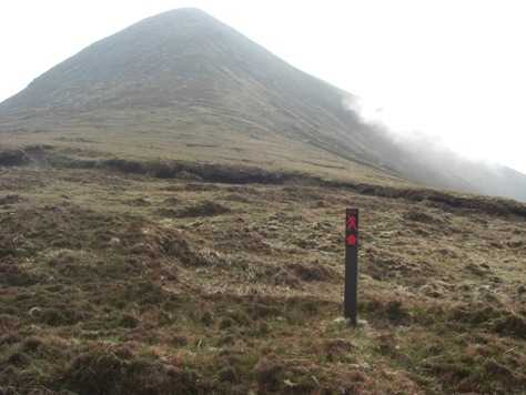
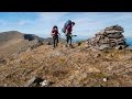
There ARE other red markers around Mastiompan; there is another one at the bottom of the NE ridge pointing back towards the one at the top. There was a 3rd post about half way down the ridge when I came down it in May 2008 but it had been uprooted. The ridge is the fast (10 mins), steep exciting route back down to the green road and the yellow-marked Dingle Way. It's also where the local wild goats hang out. Linkback: mountainviews.ie/summit/66/comment/3318/
Read Less
Read More
brenno on Masatiompan
by brenno
15 Sep 2008
Down in Dingle on w/e of Sept 13-14 with great plans to do Brandon but changed our minds when weather forecast turned out a real dud - heavy mist mean visibility above 300m would have been down to a few feet. We didn't feel like being the latest statistic for Kerry Miountain Rescue so decided on someething less challenging - following the Dingle Way from Feohanagh to the saddle between Piaras Mor and Mastiompan - up Masatiompan and then back the way we came. For a waymarked route, this is a section as remote as they come and being able to knock off Masatioman was a bonus. Like Padodes, we were a bit mystified by the red marker on the summit pointing NE - as there is no other red market post anywhere else on the Dingle Way - at least on the section W of Masatiompan - but presume it's to direct people towards Sas Creek. On a bad day when most of the Brandon range is shrouded in low cloud, climbing Masatiompan from the western section of the Dingle Way is a pretty good and safer alternative. Linkback: mountainviews.ie/summit/66/comment/3317/
Read Less
Read More
GWPR on Masatiompan
by GWPR
14 Nov 2002
Yes Milo! what a mountain! If you go this far continue north to Sas Creek.You won't be disappointed with the view. Sas means trap so don't descend!
Bran the Sea God lay down along the coast here to protect the inhabitants, one eye at Sas Creek, another at Brandon Bay and Mas A' Tiompain his hip joint. Source: Cloghane and Brandon Walking Guide by C.B.T.. Linkback: mountainviews.ie/summit/66/comment/216/
Use of MountainViews is governed by conditions and a privacy policy.
Read general information about the site. Opinions in material here are not necessarily endorsed by MountainViews.
Hillwalking is a risk sport. Information in comments, walks, shared GPS tracks or about starting places may
not be accurate for example as regards safety or access permission. You are responsible for your safety and your permission to walk.
See the credits and list definitions.


 Our Facebook page.