Members and Supporters, the MountainViews Committee requests your help to meet the costs of the website and of other activities such as insured events or publications.
Feature count in area: 15, all in Kerry,
OSI/LPS Maps: 70, EW-DC, EW-DW
Highest Place: Brandon 951.7m
Starting Places (18) in area Brandon Group: Ballinloghig, Ballybrack Mid, Brandon Pilgrimage Trail, Brandon Point, Brandon Village, Cloghane Community Centre, Conor Pass, Coosavuddig Quay Brandon Creek, Faha, Feoghanagh River, Hostel Cloghane Village, Lough Camclaun, Lough Doon CP, Mullaghveal Farm, Pedlars Lodge, Pilgrimage Trail Owenmore River, Sauce Creek Walkway Dingle Way, Tiduff
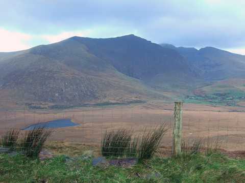
Summits & other features in area Brandon Group: Cen: Faha Ridge: Benagh 822.5m, Faha Ridge 809.2m N: Brandon Point: Faill an tSáis 430.7m N: Brandon Ridge North: Brandon Far North Top 840.1m, Brandon North Top 895.4m, Masatiompan 761.9m, Pierasmore North Top 700m, Pierasmore 745.7m S: Ballysitteragh: An Bhinn Dubh 479.2m, Ballysitteragh 623m, Beennabrack 608.5m S: Brandon Ridge South: Gearhane 803m, Brandon Peak 840m, Brandon 951.7m, Brandon South Top 790m
Note: this list of places may include island features such as summits, but not
islands as such.
Brandon, 951.7mMountain Cnoc Bréanainn A name in Irish,
Place Rating ..
(Ir. Cnoc Bréanainn [OSI], 'Brendan’s hill') Mount Brandon an extra name in English, Kerry County in Munster province, in Arderin, Vandeleur-Lynam, Irish Highest Hundred, Irish 900s Lists, Cnoc Bréanainn is the highest mountain in the Brandon Group area and the 9th highest in Ireland. Cnoc Bréanainn is the second most westerly summit in the Brandon Group area.
Grid Reference Q46042 11605,
OS 1:50k mapsheet 70 Place visited by: 1098members, recently by: kieran117, kelleher, rhw, JordanF1, MartMc, MeabhTiernan, abeach, Deirdreb, BarnabyNutt, orlaithfitz, maoris, davidrenshaw, Magic, Carolineswalsh, knightsonhikes
I visited this place: NO (You need to be a logged-in member for this.)
Longitude: -10.254336, Latitude: 52.235113, Easting: 46043, Northing: 111606,
Prominence: 934m, Isolation: 0.6km, Has trig pillar
ITM: 446026 611659 Bedrock type: Rhythmically bedded sandstone, (Ballymore Sandstone Formation) Notes on name: Brandon is the only one of Kerry's 3,000 foot peaks located outside the Reeks. It is strongly associated in tradition with St. Brendan the Navigator, from whom it gets its name. The story of St. Brendan, who set sail from Ireland in a boat of wood and leather and found new lands to the west, was popular in many countries of medieval Europe. The mountain was the focus of a pilgrimage, which probably goes back to a time before both St. Brendan and the arrival of Christianty altogether. Its importance may be due to the fact that, being so far west and so high, it is the place where the sun can be seen the latest as it sinks below the horizon. Named Brandon Mountain on OS Discovery map. Called Sliabh nDaidche in Beatha Bhréanainn, St.Brendan's Life, where it is written that he spent three days on the mountain and that he was visited by an angel. It is described as being surrounded by the ocean, which fits well with the topography of Mount Brandon. Alan Mac an Bhaird has ingeniously interpreted mons Aitche as 'mountain of Faithche'. Brandon stands in Faha townland. For further information on the name Sliabh nDaidche, see Paul Tempan, Some Notes on the Names of Six Kerry Mountains, JKAHS, ser. 2, vol. v (2005), 5-19. For the archaeology of this mountain, including the Benagh promontory fort, the Saints' Road, the pilgrimage tradition and the links with St. Brendan, see Archaeology Ireland Heritage Guide No. 29 (published March 2005). For the pilgrimage tradition and customs associated with Brandon, see Máire MacNeill, The Festival of Lughnasa, 101-05.
Short or GPS IDs, 6 char: Brndn, 10 char: Brandon Linkback: https://mountainviews.ie/summit/9/
Gallery for Brandon (Cnoc Bréanainn) and surrounds
Summary
for Brandon (Cnoc Bréanainn):
Iconic highpoint of both airy ridge and Dingle Peninsula
Summary created by markmjcampion, jackill, scapania
2023-08-16 16:26:40
Picture: The Brandon group
Brandon, named after St.Brendan, is revered by many as a holy mountain. The high point of a fine ridge between Conor Pass and the sea, it's a mountain of two halves with rocky, steep ground to the E while the W is grassy and less steep. The top can be very windy and visibility is often poor so care is needed. Be aware of the serious steep groud on the east of the summit.The views are awe inspiring on a clear day incl Connemara, Beara and everything in-between. The Galtees and Achill Island have also been known to shimmer tantalisingly at the edge of 20/20 vision!
W. From the west, park at BrDon PilTr (Q43450 09382) where there's ample space. The track follows the well-marked Saint's Road from the car park getting gradually steeper as you near the summit. Allow 4-4.5 hours for this 8k up and down.
E. From the east, park under the grotto at Faha (Q49378 11956) and follow a well-marked trail beneath the Faha ridge eventually snaking its way through a massive lake-and-rock-filled corrie. The path skirts the base of Brandon's huge NE cliffs and once you climb out of the corrie head left up a steep cone to the top. Allow 4-5 hrs for this 7k return.
Great care is needed if ascending via the Faha ridge - find details on that summit's page.
SE If ascending from the bridge at PilTr Owmor (Q49155 08556) follow the Owenmore river past a series of lakes and up steep ground by a waterfall until you eventually meet the main track from the grotto- allow 5-6 hrs.
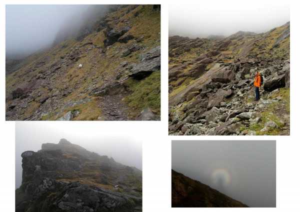
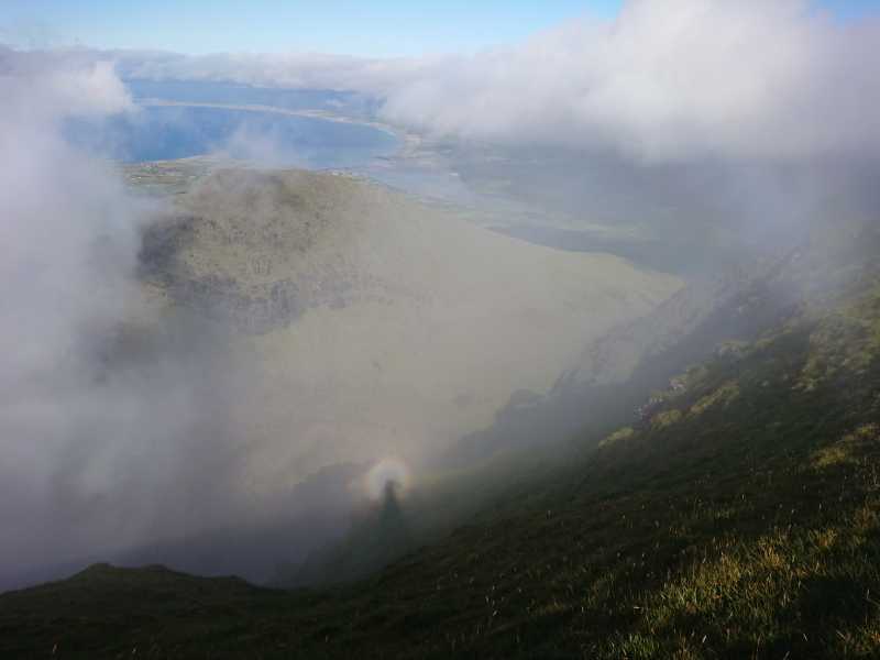
Picture: View of glacied valley and path to the summit + Brocken Spectre
from Faha Car Park to top and back
by marzka
1 May 2012
Getting there: From Tralee, follow the N86 road, follow signposts for Cloghan and just beyond the village (past the post office) take the first turn on the left which will lead you up to the Faha (An Fhaiche) car park.
The route is marked by an arrow through a gate onto the open mountainside. There are some white poles and other yellow arrow signs that indicate the route. The route first going gently along a slope then it reaches large glaciated valley full of towering cliffs, giant slabs of rocks and boulders. The valley floor consists of a series of small punchbowl corrie lakes. Then, a short scramble takes us out onto the Col on the side of Brandon and finally a short easy walk to the summit.
If the day is clear, the view must be magnificent but unfortunately when I was there the clouds covered the summit for whole day. At least I could observe the Brocken Spectre.
time: about 5 hours Linkback: mountainviews.ie/summit/9/comment/5889/
Read Less
Read More
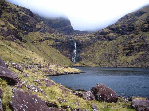
Picture: Loch na Lice with Brandon disappearing in the clouds.
liam on Brandon
by liam
18 Mar 2007
Rather than bring two cars or face the long walk back to Faha, we decided to approach Brandon via the paternoster lakes starting at A (Q491 083), two miles SW of Cloghane. The lane beside the bridge leads to a gate warning of dangerous cliffs on Brandon, some of which close the vista ahead. Two gates later we crossed over to the Owenmore River and followed it to Loch Cruite where we forded the river and passed along the east side of the lake. The waterfall ahead looked intimidating at first but proved quite manageable close up. Crossing the river about two thirds of the way up brought us to the west side of Loch na Lice with a more serious clamber ahead. Keeping to the grassy slopes on the far left we arrived at lake no.3 with superb views back down the valley towards Slievanea in the distance. Up ahead the remaining steps looked and proved a lot easier but the head of the valley and Brandon had vanished in the descending cloud. Fortunately, near the sixth lake we picked up the Pilgrims' Path markers and followed them up to the ridge near Brandon, arriving three and a half hours after leaving the car. While longer than the Faha approach, the beauty of the lakes with the cliffs towering over them and the variety of the terrain made this an unmissable experience. Given the poor visibility on the top, the highlight there was probably the narrow ridge between Brandon Peak and Gearhane before we descended on the new road at Folach na Marbh to Mullach Bhéal leaving a mile's walk back to the car. Nearly eight hours for the round trip - a bit less if conditions, physiological and climatic were better. Linkback: mountainviews.ie/summit/9/comment/2639/
Read Less
Read More
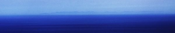
Picture: Connemara across the Atlantic
View to Connemara and Mayo
by scapania
14 Apr 2010
I just thought I'd share this photo I took of the Connemara mountains from Brandon in brilliant conditions last week. The large detached landmass to the west must be Achill, almost 200km away! Its pretty rare to get any view from the top of Brandon let alone with visibility this great, other views extended up the Clare coast from the mouth of the Shannon to Black Head in the Burren, down the coast from the Blaskets, past the Skelligs, to Dursey at the end of Beara, all the way along the Iveragh mountains out into Cork, as far as the Nagles beyond Mallow, east to the Galtees (just about), not to mention the views closer at hand of Corca Duibhne and the corries and ridges of Brandon itself. I suppose it makes up for all the times the mist has been down and you couldn't even see 2 feet in front of you. Fantastic! Linkback: mountainviews.ie/summit/9/comment/4622/
Read Less
Read More
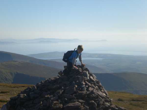
Picture: Brandon Cairn
Redtop on Brandon
by Redtop
15 Sep 2009
My name is David and I am aged 8. I climbed Brandon with my family on a beautiful warm sunny day, starting at Faha Grotto and heading West towards the summit. As I have short legs and walked slowly, it took us nearly 7 hours round-trip. The hardest part was from the last lake scrambling up to the summit but we made it to the top. We saw people swimming in the lakes. I came down much faster and especially liked sliding down the steep bit just below the summit. My Dad had to hold on to me. I like to bring a rock from every climb home with me. Linkback: mountainviews.ie/summit/9/comment/4099/
Read Less
Read More
Picture: Brocken Spectre from summit of Brandon. 8th July, 2018 at 17:50.
Use of MountainViews is governed by conditions and a privacy policy.
Read general information about the site. Opinions in material here are not necessarily endorsed by MountainViews.
Hillwalking is a risk sport. Information in comments, walks, shared GPS tracks or about starting places may
not be accurate for example as regards safety or access permission. You are responsible for your safety and your permission to walk.
See the credits and list definitions.


 Our Facebook page.