Members and Supporters, the MountainViews Committee requests your help to meet the costs of the website and of other activities such as insured events or publications.
Feature count in area: 15, all in Kerry,
OSI/LPS Maps: 70, EW-DC, EW-DW
Highest Place: Brandon 951.7m
Starting Places (18) in area Brandon Group: Ballinloghig, Ballybrack Mid, Brandon Pilgrimage Trail, Brandon Point, Brandon Village, Cloghane Community Centre, Conor Pass, Coosavuddig Quay Brandon Creek, Faha, Feoghanagh River, Hostel Cloghane Village, Lough Camclaun, Lough Doon CP, Mullaghveal Farm, Pedlars Lodge, Pilgrimage Trail Owenmore River, Sauce Creek Walkway Dingle Way, Tiduff
Summits & other features in area Brandon Group: Cen: Faha Ridge: Benagh 822.5m, Faha Ridge 809.2m N: Brandon Point: Faill an tSáis 430.7m N: Brandon Ridge North: Brandon Far North Top 840.1m, Brandon North Top 895.4m, Masatiompan 761.9m, Pierasmore North Top 700m, Pierasmore 745.7m S: Ballysitteragh: An Bhinn Dubh 479.2m, Ballysitteragh 623m, Beennabrack 608.5m S: Brandon Ridge South: Gearhane 803m, Brandon Peak 840m, Brandon 951.7m, Brandon South Top 790m
Note: this list of places may include island features such as summits, but not
islands as such.
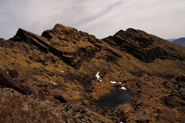
Faha Ridge, 809.2mMountain Na Poirt A name in Irish,
Place Rating ..
(Ir. Na Poirt [TCCD*], 'the fortifications'), Kerry County in Munster province, in Arderin, Vandeleur-Lynam, Irish Best Hundred Lists, Na Poirt is the 36th highest place in Ireland.
Grid Reference Q46437 12048,
OS 1:50k mapsheet 70 Place visited by: 276members, recently by: kelleher, rhw, davidrenshaw, MeabhTiernan, abeach, maoris, Carolineswalsh, Padraigin, ToughSoles, Kaszmirek78, Barrington1978, Carolyn105, SmirkyQuill, Beti13, amacsweeney
I visited this place: NO (You need to be a logged-in member for this.)
Longitude: -10.24877, Latitude: 52.239202, Easting: 46437, Northing: 112049,
Prominence: 41m, Isolation: 0.5km ITM: 446420 612102 Bedrock type: Rhythmically bedded sandstone, (Ballymore Sandstone Formation) Notes on name: This is the airy arete located west of Benagh promontory fort. It drops steeply to the south into Com an Chnoic, and even more abruptly to the north into Coimín na gCnámh. Previously Brandon Mtn North East Top in MV.
Short or GPS IDs, 6 char: FhRdg, 10 char: Faha Ridge Linkback: https://mountainviews.ie/summit/35/
Gallery for Faha Ridge (Na Poirt) and surrounds
Summary
for Faha Ridge (Na Poirt):
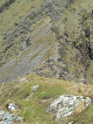
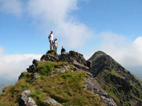
Careful now Ted!
Summary created by scapania, jackill
2011-01-26 20:16:55
Picture: The Faha ridge rising above the Pater Noster Lakes
Start at the carpark under the Faha Grotto( marked on OS map) on the hillside overlooking Cloghane. There is room for 8-10 cars.
Walk up the track past grotto and on until you cross over a wire fence. At this point you will be near the crest of the ridge.
Leave the path and continue on up to the crest of the ridge after the wire fence and follow a low line of stones upwards. This stone line will after a short distance start to veer to the left away from the crest of the ridge. Do not follow it, stay near to the crest which will turn slowly towards the right. You will eventually gain a grassy platform (Benagh)after crossing another fence at about 790/800 meters elevation, here starts the more difficult section which has many rocky steps to negotiate.
Be very sure about the ability of your party before attempting this ridge.
It is difficult in good weather and in bad weather/visibility/winds might not be such a good idea.
If you decide to do it then stay as close to the top as possible.The summit is just before the drop down to the side of the large rock slab.
Proceeding east to west, you descend from the north east top onto a grassy platform but do not need to venture onto the knife edge. You escape through the band of rocks to the right by descending a short chimney, much easier than it looks at first sight. GWPR's photograph (in Brandon Mountain portfolio) was taken near the foot of the chimney, and shows the way forward from there. Linkback: mountainviews.ie/summit/35/comment/1753/
Read Less
Read More
skyehigh on Faha Ridge
by skyehigh
12 Jun 2005
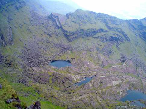
This photo gives a clearer view of the route down from the north east top. The chimney leads down to the grassy ledge, which connects with the col. The photo also gives an impression of the terrain you have to negotiate to reach Brandon's main ridge in the vicinity of the north top. Linkback: mountainviews.ie/summit/35/comment/1754/
Read Less
Read More
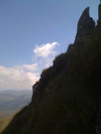
Picture: The nose-bleed section
jackill on Faha Ridge
by jackill
6 Sep 2006
Faha Ridge (centre of photo) as viewed from the southern slopes of Mount Brandon heading toward Brandon Peak.
The path from Cloghane winds is way through the Locha Chom an Cnoic on the valley floor below before the short climb on to the ridge and the final 150 mtrs up to the summit of Mount Brandon. Linkback: mountainviews.ie/summit/35/comment/1421/
EAST (Faha) RIDGE route: Grade 1 scramble: technically easy, but exposure can be impressive - especially on the ridge's north side. The ascent from Faha/the Grotto (OSi map 70 Grid ref Faha (Q493 119)) up the slopes to the start of the ridge proper (point 822) is hard graft through trackless heather - best option is to aim for the remains of the ridge wall (grid ref A (Q487 123)) and walk along that as much as possible. The scrambling section begins at point 822 (grid ref B (Q469 119)) and is superb. Individual difficulties can be avoided, most specifically a flat knife edge section with a 10m drop at it's end - avoided via a steep descent path on it's right hand/north side - but beyond retreating the ridge overall appears to be largely inescapable, with one break in the encircling cliffs on the south side only obvious from below. The views down into the savage glen of the Paternoster lakes with Brandon's ridges falling in parallel are stupendous. The obvious steeper upper section of the ridge that rises direct to the summit plateau from the small col is a genuine rock climb; avoid this via the steep slopes on the right which take you direct to the subsidiary point 891 from where the summit is an easy stroll. Magnificent views. A classic route on one of the greatest mountains in these islands. Linkback: mountainviews.ie/summit/35/comment/3510/
Use of MountainViews is governed by conditions and a privacy policy.
Read general information about the site. Opinions in material here are not necessarily endorsed by MountainViews.
Hillwalking is a risk sport. Information in comments, walks, shared GPS tracks or about starting places may
not be accurate for example as regards safety or access permission. You are responsible for your safety and your permission to walk.
See the credits and list definitions.


 Our Facebook page.