Members and Supporters, the MountainViews Committee requests your help to meet the costs of the website and of other activities such as insured events or publications.
Feature count in area: 15, all in Kerry,
OSI/LPS Maps: 70, EW-DC, EW-DW
Highest Place: Brandon 951.7m
Starting Places (18) in area Brandon Group: Ballinloghig, Ballybrack Mid, Brandon Pilgrimage Trail, Brandon Point, Brandon Village, Cloghane Community Centre, Conor Pass, Coosavuddig Quay Brandon Creek, Faha, Feoghanagh River, Hostel Cloghane Village, Lough Camclaun, Lough Doon CP, Mullaghveal Farm, Pedlars Lodge, Pilgrimage Trail Owenmore River, Sauce Creek Walkway Dingle Way, Tiduff
Summits & other features in area Brandon Group: Cen: Faha Ridge: Benagh 822.5m, Faha Ridge 809.2m N: Brandon Point: Faill an tSáis 430.7m N: Brandon Ridge North: Brandon Far North Top 840.1m, Brandon North Top 895.4m, Masatiompan 761.9m, Pierasmore North Top 700m, Pierasmore 745.7m S: Ballysitteragh: An Bhinn Dubh 479.2m, Ballysitteragh 623m, Beennabrack 608.5m S: Brandon Ridge South: Gearhane 803m, Brandon Peak 840m, Brandon 951.7m, Brandon South Top 790m
Note: this list of places may include island features such as summits, but not
islands as such.
Benagh, 822.5mMountain Binn Fhaiche A name in Irish,
Place Rating ..
(Ir. Binn Faiche [TCCD*], 'peak of Faha'), Binn Faha, Kerry County in Munster province, in Arderin, Vandeleur-Lynam, Irish Best Hundred Lists, Binn Fhaiche is the 32nd highest place in Ireland.
Grid Reference Q46909 11926,
OS 1:50k mapsheet 70 Place visited by: 210members, recently by: kelleher, rhw, davidrenshaw, abeach, maoris, Carolineswalsh, ToughSoles, Carolyn105, Beti13, amacsweeney, bagoff, No1Grumbler, osullivanm, farmerjoe, Krzysztof_K
I visited this place: NO (You need to be a logged-in member for this.)
Longitude: -10.241801, Latitude: 52.238235, Easting: 46910, Northing: 111926,
Prominence: 57m, Isolation: 0.5km ITM: 446893 611979 Bedrock type: Rhythmically bedded sandstone, (Ballymore Sandstone Formation) Notes on name: The name Benagh is marked on the OS 6 map. An Fhaiche / Faha is the name of the townland in which this peak is situated. The grotto at which the traditional ascent of the mountain begins is further down in the same townland. The walls E of the summit were identified as the remains of an inland promontory fort by archaeologist Barry Raftery. For information on this fort, see Archaeology Ireland Heritage Guide No. 29 (published March 2005). Previously Brandon Mtn East Top in MV.
Short or GPS IDs, 6 char: Benagh, 10 char: Benagh Linkback: https://mountainviews.ie/summit/30/
Gallery for Benagh (Binn Fhaiche) and surrounds
Summary
for Benagh (Binn Fhaiche):
What a view!
Summary created by Peter Walker, jackill
2018-09-25 19:49:01
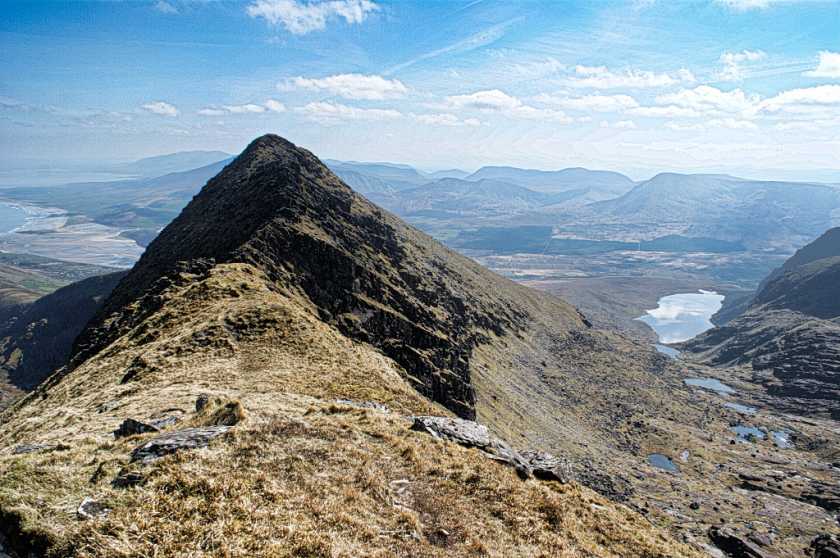
Picture: Benagh from the west
Start at the carpark under the Faha Grotto( marked on OS map) on the hillside overlooking Cloghane. There is room for 8-10 cars.
Walk up the track past grotto and on until you cross over a wire fence. At this point you will be near the crest of the ridge. .
Leaving the path here continue on up to the crest of the ridge after the wire fence and follow a low line of stones upwards. This stone line will after a short distance start to veer to the left away from the crest of the ridge. Do not follow it, stay near to the crest which will turn slowly towards the right. You will eventually gain a grassy platform after crossing another fence at about 790/800 meters elevation , this is the summit area
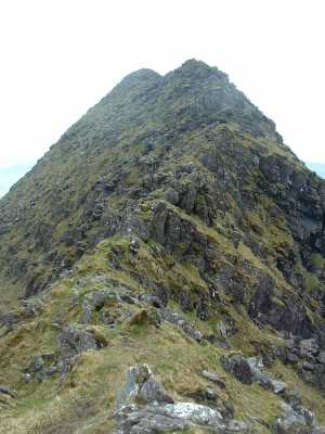
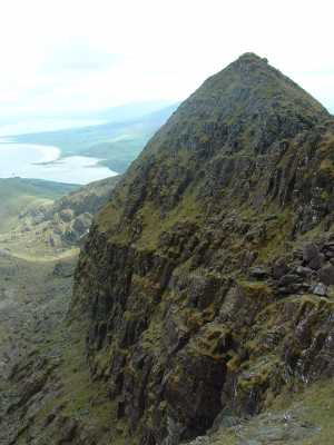
Picture: Brandon East Top from the low point between the tops
skyehigh on Benagh
by skyehigh
12 Jun 2005
29 May 2005. Brandon clear! I had aborted a climb the previous day, preferring sunshine on Ballydavid Head, Sybil Head and Mount Eagle to murk and showers on Brandon, and just had to take advantage of this opportunity. I planned to follow the Faha ridge (a "piece of cake", according to another climber I met - I reserved judgement on that) and take in all the tops north of Brandon senior. Anyway, the climb to the east top could hardly be easier, and on this fine day the views were breathtaking. Once the east top is reached, the walking is interspersed with scrambling. I was reminded of Aonach Eagach in Glencoe, though the scrambles here are shorter and the ridge itself is much shorter. And as I hadn't traversed the ridge before, I was always mindful that negotiating the final obstacle could be tricky...... Linkback: mountainviews.ie/summit/30/comment/1749/
Read Less
Read More
skyehigh on Benagh
by skyehigh
12 Jun 2005
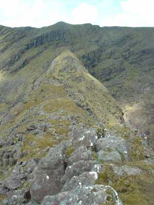
This picture was taken after descending part way from the east top. It shows the north east top with the north top directly behind. Linkback: mountainviews.ie/summit/30/comment/1751/
Read Less
Read More
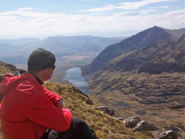
Picture: Loch Cruite
Spectacular
by Colin Murphy
11 May 2010
Followed the track from the Faha Grotto to point A (Q118 488) then ascended a very steep slope to top of ridge. The approach to Benagh follows a very narrow track with spectacular views into the valley floor. Beyond Benagh towards Faha Ridge becomes extremely tricky and dangerous in bad conditions. I notice that in a previous comment from skyehigh, he met a walker who described it as a 'piece of cake'. This is rubbish. The narrow track weaves in, out and over huge boulders and people have been killed on this track in the past. So extreme caution is necessary. Having said that, it's doable with care and is certainly among the most spectacular routes in Ireland, especially on a clear day. Linkback: mountainviews.ie/summit/30/comment/4716/
Read Less
Read More
jackill on Benagh
by jackill
15 Jan 2005
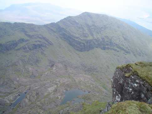
Brandon Mountain East Top in the centre of the picture viewed from the Brandon Ridge between Brandon Mountain and Drom na Muice. Below on the valley floor you can see the Locha Choim an Chnoic and just above them the path that starts out at the Faha grotto above Cloghane.The walk up this path is quite easy going and well defined and offers great views down to the lakes and back over Brandon Bay to Tralee. Linkback: mountainviews.ie/summit/30/comment/1420/
Read Less
Read More
skyehigh on Benagh
by skyehigh
12 Jun 2005
I finally managed to find a view of the east top which does it justice. The viewpoint is below the north top (point 891). Linkback: mountainviews.ie/summit/30/comment/1752/
Use of MountainViews is governed by conditions and a privacy policy.
Read general information about the site. Opinions in material here are not necessarily endorsed by MountainViews.
Hillwalking is a risk sport. Information in comments, walks, shared GPS tracks or about starting places may
not be accurate for example as regards safety or access permission. You are responsible for your safety and your permission to walk.
See the credits and list definitions.


 Our Facebook page.