Donation Request 2024
You do not have to be logged in to donate.
DONATE
Members and Supporters, the MountainViews Committee requests your help to meet the costs of the website and of other activities such as insured events or publications.You do not have to be logged in to donate.
Welcome to MountainViews
If you want to use the website often please enrol (quick and free) at top right.
If you want to use the website often please enrol (quick and free) at top right.
Overview

For more map options click on any overview map area or any detail map feature.
Detail Map Features
Find Suggested Walks
Find hill, mountain, island, coastal feature.
Videos
Recent Contributions
 Get Notifications
Get Notifications
Crocknapeast: Long walk up windfarm roads.
 Collaborative entry
Double bag mostly on windfarm tracks.
 Colin Murphy
Mulnanaff: Longish walk up windfarm road.
 Collaborative entry
Good, relatively easy double bag
 Colin Murphy
Binbane NE Top: Simple bag from its neighbouring top.
 Collaborative entry
Binbane: Steepish approach to relatively easy Carn.
 Collaborative entry
Lake District: Dale Head Horseshoe
Crucknaree: Magnificent views!
 paddyhillsbagger
Lake District: Coledale Horseshoe
Dunranhill: Sika deer and sitka spruce
 hibby
hibby
Crocknasharragh: Impressive views on initial ascent.
 Colin Murphy
Longish walk to isolated top
 Colin Murphy
Conditions and Info
Use of MountainViews is governed by conditions and a privacy policy.
Read general information about the site.
Opinions in material here are not necessarily endorsed by MountainViews.
Hillwalking is a risk sport. Information in comments, walks, shared GPS tracks or about starting places may not be accurate for example as regards safety or access permission. You are responsible for your safety and your permission to walk.
See the credits and list definitions.
 Visit our Facebook page.
Video display
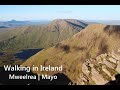
Mweelrea
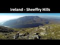
Area W: Mweelrea Subarea
Place count in area: 12,
OSI/LPS Maps: 37, EW-CON, MSW
Highest place: Mweelrea, 814m
Maximum height for area: 814 metres,
Maximum prominence for area: 779 metres,
Places in area Mweelrea:
E: Ben Gorm Mountains:Ben Creggan 693mBen Creggan South Top 687mBen Gorm 700m
W: Mweelrea:Ben Bury 795mBen Lugmore 803mBen Lugmore East Top 790mBen Lugmore West Top 790mCorrymailley Hill 286mMweelrea 814mMweelrea SE Spur 495mTawnydoogan 312mTeevnabinnia 379m
Note: this list of places includes island features such as summits, but not islands as such.
Highest place:
Mweelrea, 814mPlaces in area Mweelrea:
E: Ben Gorm Mountains:
Ben Creggan 693mBen Creggan South Top 687mBen Gorm 700mW: Mweelrea:
Ben Bury 795mBen Lugmore 803mBen Lugmore East Top 790mBen Lugmore West Top 790mCorrymailley Hill 286mMweelrea 814mMweelrea SE Spur 495mTawnydoogan 312mTeevnabinnia 379mNote: this list of places includes island features such as summits, but not islands as such.

Bedrock type: Sandstone & conglomerate, ignimbrite, (Mweelrea Formation)
Ben Lugmore is the second highest mountain in the Mweelrea area and the 39th highest in Ireland. Ben Lugmore is the third highest point in county Mayo.
Linkback: https://mountainviews.ie/summit/38/
COMMENTS for Ben Lugmore (Binn Log Mhór) 1 2 Next page >>  Follow this place's comments

|
|
|
|
||
| MountainViews.ie, a Hill-walking Website for the island of Ireland. 2400 Summiteers, 1480 Contributors, maintainer of lists: Arderins, Vandeleur-Lynams, Highest Hundred, County Highpoints etc | |||