Members and Supporters, the MountainViews Committee requests your help to meet the costs of the website and of other activities such as insured events or publications.
Feature count in area: 12, all in Mayo,
OSI/LPS Maps: 37, EW-CON, MSW
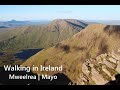
Highest Place: Mweelrea 814m
Starting Places (31) in area Mweelrea: Aasleagh Waterfall CP, Ben Creggan N, Bundorragha Estuary Cross, Bunleemshough River Source, Carraig Bar, Delphi Resort, Dernasliggaun, Doo Lough N, Doo Lough SE, Fee Lough SW, Foher, Glencraff Road End, Glencullin Lough CP, Glendavock, Glenummera River, Illaunroe North, Illaunroe South, Killary Boat Tour Pier W, Leenane, Leenane Hotel, unuseableLeenane R336, Lough Fee East, Muck Lough NW, Nambrackkeagh Lough, Owenduff River, Owengar Bridge, Owenwee River, Sean Scoil an Talaimh Bháin, Silver Strand Road, Tawnydoogan Forest Central, Tawnydoogan Forest North
Summits & other features in area Mweelrea: E: Ben Gorm Mountains: Ben Creggan 693m, Ben Creggan South Top 687m, Ben Gorm 700m W: Mweelrea: Ben Bury 795m, Ben Lugmore 803m, Ben Lugmore East Top 790m, Ben Lugmore West Top 790m, Corrymailley Hill 286m, Mweelrea 814m, Mweelrea SE Spur 495m, Tawnydoogan 312m, Teevnabinnia 379m
Note: this list of places may include island features such as summits, but not
islands as such.
Ben Lugmore West Top, 790mMountain Binn an Loig Mhóir (mullach thiar) A name in Irish,
Place Rating ..
For origin of name, see Ben Lugmore., Mayo County in Connacht province, in Arderin, Vandeleur-Lynam, Irish Best Hundred Lists, Ben Lugmore West Top is the 53rd highest place in Ireland.
Grid Reference L80585 67678,
OS 1:50k mapsheet 37 Place visited by: 376members, recently by: glencree, nupat, NualaB, rhw, taramatthews, orlaithfitz, PiotrR, Carolineswalsh, Tuigamala, ronanmckee, ToughSoles, Kaszmirek78, Lyner, Moirabourke, amacsweeney
I visited this place: NO (You need to be a logged-in member for this.)
Short or GPS IDs, 6 char: BnL791, 10 char: BnLgmrWstT Linkback: https://mountainviews.ie/summit/50/
Gallery for Ben Lugmore West Top (Binn an Loig Mhóir (mullach thiar)) and surrounds
Summary
for Ben Lugmore West Top (Binn an Loig Mhóir (mullach thiar)):
A jagged summit on a jagged ridge
Summary created by Colin Murphy, wicklore
2016-05-30 16:05:02
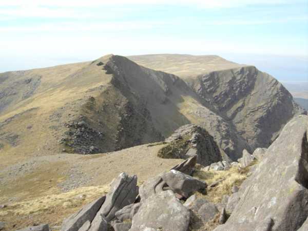
Picture: Ben Lugmore West Top with Ben Bury beyond
The Ben Lugmore Ridge can be reached from the east by parking at DooL N (L82820 69529), and following the Green Ramp route up onto the col between Ben Bury and Ben Lugmore West Top at A (L805 679). Turn left (southeast) at the col to begin the walk south along the jagged and dramatic Ben Lugmore Ridge. Ben Lugmore West Top is reached after a 45 metre climb over about 250 metres distance. Care is needed not to wander off the sheer cliffs to the left (east) of the summit. In July 2009 an experienced hiker out walking with her husband fell to her death in this area, so caution is advised. However in good conditions Ben Lugmore West Top is easily manageable. The views are breathtaking, taking in Mweelrea and other immediate summits, as well as the Sruhauncullinmore valley below to the east and across to Killary Harbour to the west.
An alternative approach is from the south east. For details see short summary for Ben Lugmore East Top. Having passed that summit and subsequently Ben Lugmore, the West Top is a simple 500m trek to the NW across solid terrain that is a mixture of grass and rock.
This is either the first or last summit in the Lugmore Ridge - three first rate tops that offer everything a hillwalker can desire - height, prominence, rugged beauty and breathtaking scenery all round, not to mention an element of danger, given the precipitous drops to one side. On top of all that you get to bag three tops in just over 1km's distance! Linkback: mountainviews.ie/summit/50/comment/18545/
Read Less
Read More
Picture: tops of Ben Lugmore and Ben Bury from Barraclashcarne
gerrym on Ben Lugmore West Top
by gerrym
1 Mar 2008
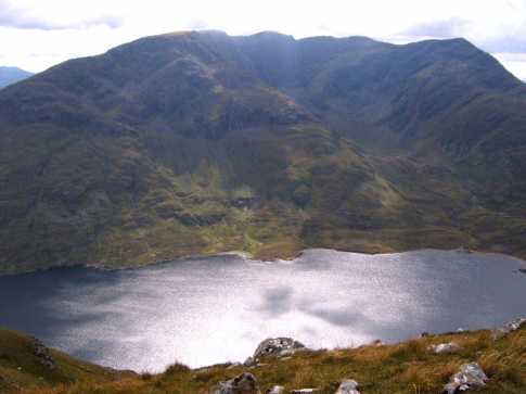
The west top of Ben Lugmore is reached from the high col with Ben Bury (see for route to col). On reaching the col i opted to visit Ben Bury and then Mweelrea itself before cutting back across the shoulder of Ben Bury to the small cairn at the col again. The climb itself is fairly short and undemanding, having done plenty of work up through the corrie to the col. While not demanding it is spectacular, with the backdrop of the whole of Connemara mountains in view and more immediately the breaththaking steep drops into the big corrie to the left and long sweeping slopes into the corrie on the right. The views are quite simply fantastic - across the loughs of Doo and Glencullin to Barraclashcarne and the long line of the Sheefrys, to C Patrick, great views of Ben Creggan and Ben Gorm, cruisers making thier way along Killary Harbour. There is no doubt that the views down into the corrie are the draw and with only a gentle breeze i was able to stand and peer down to the Sruhauncullinmore river far below. I wonder on just how many days in the year this would be possible with cloud or wind hindering the sight? The sound of the rivers dropping down into Lough Bellawaum give the ears some thing to relish, with the optical overload already accomplished. The rest of the high level traverse across the abruptly cut away tops of Ben Lugmore and the E top, as they arc around the corrie, are well laid out from here. Linkback: mountainviews.ie/summit/50/comment/2460/
Read Less
Read More
madfrankie on Ben Lugmore West Top
by madfrankie
21 Aug 2006
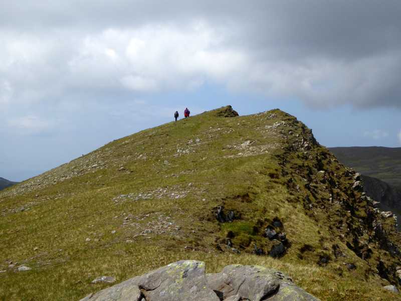
From Ben Lugmore the ridge continues much as it had done from Ben Lugmore East Top: narrow ridge with cataclysmic drops on your right hand side. But there is an intermittent path (not that you need one), and it takes only a few minutes to reach the summit, denoted with a small upright stone. Now the ground slopes gently to the col with Ben Bury. Linkback: mountainviews.ie/summit/50/comment/2469/
Read Less
Read More
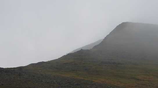
Picture: Ben Lugmore West Top viewed from the col between it and Ben Bury, with the cliffs of Glencullin to t
csd on Ben Lugmore West Top
by csd
23 Nov 2005
See my entry for Ben Bury for a route up from Glencullin. Turning left instead of right at the cairn will bring you to Ben Luugmore instead of Ben Bury. Not a great day for photography, but the picture gives you an idea of the ascent up to the summit of West Top from the cairn at the top of the ramp from Glencullin. Linkback: mountainviews.ie/summit/50/comment/2063/
Read Less
Read More
Geo on Ben Lugmore West Top
by Geo
11 Oct 2009
My comments would be wasted here as we followed the same route as gerrym and I agree wholeheartedly with his assessment of the views etc. A fantastic day in a fantastic place. Thank god for the Ice Age! Linkback: mountainviews.ie/summit/50/comment/4196/
Use of MountainViews is governed by conditions and a privacy policy.
Read general information about the site. Opinions in material here are not necessarily endorsed by MountainViews.
Hillwalking is a risk sport. Information in comments, walks, shared GPS tracks or about starting places may
not be accurate for example as regards safety or access permission. You are responsible for your safety and your permission to walk.
See the credits and list definitions.


 Our Facebook page.