This website uses cookies, which are small text files that the website puts on your device to facilitate operation. Cookies help us provide a better service to you. They are used to track general user traffic information and to help the website function properly.
Feature count in area: 12, all in Mayo,
OSI/LPS Maps: 37, EW-CON, MSW
Highest Place: Mweelrea 814m
Starting Places (31) in area Mweelrea: Aasleagh Waterfall CP, Ben Creggan N, Bundorragha Estuary Cross, Bunleemshough River Source, Carraig Bar, Delphi Resort, Dernasliggaun, Doo Lough N, Doo Lough SE, Fee Lough SW, Foher, Glencraff Road End, Glencullin Lough CP, Glendavock, Glenummera River, Illaunroe North, Illaunroe South, Killary Boat Tour Pier W, Leenane, Leenane Hotel, unuseableLeenane R336, Lough Fee East, Muck Lough NW, Nambrackkeagh Lough, Owenduff River, Owengar Bridge, Owenwee River, Sean Scoil an Talaimh Bháin, Silver Strand Road, Tawnydoogan Forest Central, Tawnydoogan Forest North
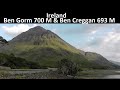
Summits & other features in area Mweelrea: E: Ben Gorm Mountains: Ben Creggan 693m, Ben Creggan South Top 687m, Ben Gorm 700m W: Mweelrea: Ben Bury 795m, Ben Lugmore 803m, Ben Lugmore East Top 790m, Ben Lugmore West Top 790m, Corrymailley Hill 286m, Mweelrea 814m, Mweelrea SE Spur 495m, Tawnydoogan 312m, Teevnabinnia 379m
Note: this list of places may include island features such as summits, but not
islands as such.
Teevnabinnia, 379mHill Taobh na Binne A name in Irish,
Place Rating ..
(Ir. Taobh na Binne [MNIMA], 'side of the peak'), Ben Leiva, Pat's Hill, Mayo County in Connacht province, in Binnion Lists, Teevnabinnia is the 1001th highest place in Ireland. Teevnabinnia is the most southerly summit in the Mweelrea area.
Grid Reference L82554 64167,
OS 1:50k mapsheet 37 Place visited by: 63members, recently by: eamonoc, paulbrown, eflanaga, GerSomers, elizauna, JohnRea, John.geary, march-fixer, andren64, Carolyn105, dregish, Maire-Ni, FrankMc1964, Fergalh, abcd
I visited this place: NO (You need to be a logged-in member for this.)
Longitude: -9.775402, Latitude: 53.614319, Easting: 82554, Northing: 264167,
Prominence: 214m, Isolation: 3.2km ITM: 482529 764186 Bedrock type: Sandstone & conglomerate, ignimbrite, (Mweelrea Formation) Notes on name: Located on the townland boundary of Tonatleva and Bundorragha.
Short or GPS IDs, 6 char: Tvn379, 10 char: Tevnabinia Linkback: https://mountainviews.ie/summit/869/
Gallery for Teevnabinnia (Taobh na Binne) and surrounds
Summary
for Teevnabinnia (Taobh na Binne):
Hill overlooks Killary Fjord on ridge to Mweelrea
Summary created by simon3
2022-01-23 09:45:48
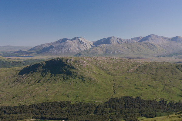
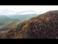
Picture: Teevenabinnia with a view to the 12 Bens and much more.
Glance at the map and you will see that Killary Fjord bends around this summit. From near the top you can see water for 180 degrees. Seven major Connemara or south Mayo ranges are visible from the top in addition. A remarkable view.
On a good day the summit is worth doing as a shortish trip in its own right or as part of a Mweelrea circuit. An obvious place to start is from the vicinity of the Delphi Mountain Resort. There is parking at the centre (it's polite to buy a drink if you are using it) or beside the road including at a nearby bridge.
The quickest way is along a forest track starting at around A (L84080 64678) Walk east from there and leave the trees at around B (L83528 64634) head for the col to the SE of the top for a clear view to the fjord.
The actual summit has a cairn however the highest point is a sculpted piece of solid rock. Admire the extraordinary views.
This relatively unvisited and unsung place actually has magnificent views because of its location.
This is illustrated in the photo with the 12 Bens to the right, the Maamturks to the left and ridge leading from Ben Lugmore (East) in front. Also visible from the top but not the picture are the Ben Gorms, the Sheefrys, some of the Devil's Mother and even a bit of the Partry/Joyce area. Linkback: mountainviews.ie/summit/869/comment/5893/
Read Less
Read More
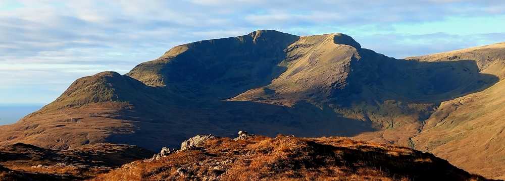
Picture: Mweelrea from Teevnabinnia
A worthy end to a fine circuit.
by eamonoc
9 Dec 2023
Climbed as part of Mweelrea circuit on 29th Nov,
it is a bit of a slog for tired legs after Mweelrea SE spur. The day was stunning, full on winter sunshine with incredible views, after summiting it was an easy descent to the road towards Bundorragha river. Linkback: mountainviews.ie/summit/869/comment/24083/
Read Less
Read More
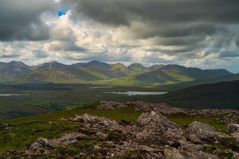
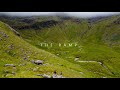
Picture: 12 Bens from Teevnabinnia
Nice views for a little Mountain
by andren64
18 Oct 2020
We were in Leenaun for several days. Since my wife is not so fit for climbing mountains, healthwise, we decided to go for this little mountain. There is a parking lot in front of the Delphi Adventure Center where you can walk a forest path. Until it goes left over a small stream up the mountain. The way is wet! There was a rain shower when we got to the top, but the great view made up for it. A beautiful view of the Killary Fjord and the 12 bens! Linkback: mountainviews.ie/summit/869/comment/20968/
Use of MountainViews is governed by conditions and a privacy policy.
Read general information about the site. Opinions in material here are not necessarily endorsed by MountainViews.
Hillwalking is a risk sport. Information in comments, walks, shared GPS tracks or about starting places may
not be accurate for example as regards safety or access permission. You are responsible for your safety and your permission to walk.
See the credits and list definitions.


 Our Facebook page.