Members and Supporters, the MountainViews Committee requests your help to meet the costs of the website and of other activities such as insured events or publications.
Feature count in area: 12, all in Mayo,
OSI/LPS Maps: 37, EW-CON, MSW
Highest Place: Mweelrea 814m
Starting Places (31) in area Mweelrea: Aasleagh Waterfall CP, Ben Creggan N, Bundorragha Estuary Cross, Bunleemshough River Source, Carraig Bar, Delphi Resort, Dernasliggaun, Doo Lough N, Doo Lough SE, Fee Lough SW, Foher, Glencraff Road End, Glencullin Lough CP, Glendavock, Glenummera River, Illaunroe North, Illaunroe South, Killary Boat Tour Pier W, Leenane, Leenane Hotel, unuseableLeenane R336, Lough Fee East, Muck Lough NW, Nambrackkeagh Lough, Owenduff River, Owengar Bridge, Owenwee River, Sean Scoil an Talaimh Bháin, Silver Strand Road, Tawnydoogan Forest Central, Tawnydoogan Forest North
Summits & other features in area Mweelrea: E: Ben Gorm Mountains: Ben Creggan 693m, Ben Creggan South Top 687m, Ben Gorm 700m W: Mweelrea: Ben Bury 795m, Ben Lugmore 803m, Ben Lugmore East Top 790m, Ben Lugmore West Top 790m, Corrymailley Hill 286m, Mweelrea 814m, Mweelrea SE Spur 495m, Tawnydoogan 312m, Teevnabinnia 379m
Note: this list of places may include island features such as summits, but not
islands as such.
Mweelrea, 814mMountain Maol Réidh A name in Irish,
Place Rating ..
(Ir. Cnoc Maol Réidh [GE], 'bald hill with the smooth top'), Muilrea County Highpoint of Mayo in Connacht province, in County Highpoint, Arderin, Vandeleur-Lynam, Irish Best Hundred, Irish Highest Hundred Lists, Mweelrea is the highest mountain in the Mweelrea area and the 35th highest in Ireland. Mweelrea is the highest point in county Mayo.
Grid Reference L78983 66810,
OS 1:50k mapsheet 37 Place visited by: 968members, recently by: abbiew1001, kelleher, dolan931, rhw, purpleknight, MeabhTiernan, discovering_dann, taramatthews, orlaithfitz, PiotrR, davidrenshaw, Mikejones, Carolineswalsh, knightsonhikes, JordanF1
I visited this place: NO (You need to be a logged-in member for this.)
Longitude: -9.830313, Latitude: 53.637241, Easting: 78983, Northing: 266810,
Prominence: 779m, Isolation: 1.5km ITM: 478962 766828 Bedrock type: Sandstone & conglomerate, ignimbrite, (Mweelrea Formation) Notes on name: Mweelrea is the highest mountain in Connacht. The use of the adjective réidh, ‘smooth’, does not have many parallels in Irish hill-names and seems rather unsuited to rugged Mweelrea. Whilst impossible to prove, it seems plausible that this was once a Brittonic name containing bre, comparable to Welsh moelfre ‘bald hill’, of which there are at least seven instances in Wales. A number of townlands in Co. Down called Drummiller or Miller Hill could well have the same origin, the addition of tautological Ir. droim or Eng. hill being a later development.
Short or GPS IDs, 6 char: Mwlr, 10 char: Mweelrea Linkback: https://mountainviews.ie/summit/34/
Gallery for Mweelrea (Maol Réidh) and surrounds
Summary
for Mweelrea (Maol Réidh):
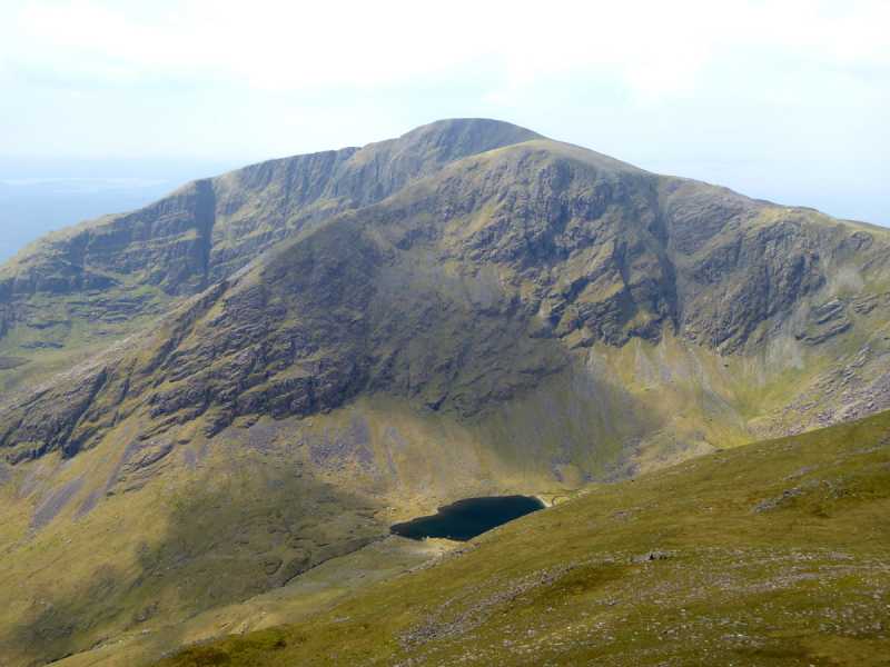
The high point of a steep-sided rugged massif - Connaught’s highest.
Summary created by markmjcampion, Colin Murphy, Harry Goodman, simon3, jackill, Pazapas
2023-08-18 16:07:05
Picture: Mweelrea seen from Ben Lugmore
Mweelrea, a flat-topped seaside summit, presents magnificent scenery but is a mt which must be treated with respect. In poor visibility good route choice and navigational skills are essential. Superb views incl Conemara, Sheffreys, C. Patrick and out to sea.
W. For the most direct albeit boggy approach, start at SilStr Rd (L76457 68831) and take a rough farm track E. At end, cross gate and head SE for 2km to a stream junction A (L77976 67639). Keeping river on right continue up more steeply E to a col B (L79297 67599) and then go SSW up to the summit. [2.5 hrs]
NE. Park at the N end of Doo Lough DooL N (L82800 69544). Head SW and follow the Sruhauncullin stream up and into a large corrie. At approx. C (L81558 67631) take a broad grassy ramp up to the right - this is a steep traverse especially near top. Once out on the broad flat ridge go W and contour around the slopes of Ben Bury to the aforementioned col before heading up steeply SSW to the top. [3 hrs+]
E. Starting from the Delphi Activity Centre D (L839 652) or beside the bridge at E (L84103 65155). Follow the line of the Owennaglogh River west. Once beyond the forest go up SW to a col on the ridge above F (L80675 64893) and head NW to cross the minor top of Mweelrea SE Spur. Continuing NW descend to a high col and the start of steep ascent initially up NW and then due N around the rim of a deep corrie. [3 hrs+] A circuit is possible by heading back to start via Ben Bury and the Lugmores.
Notable tracks incl track/3592, track/1999 and track/4220
Really enjoyed my ascent of this peak on 11 Sept 04, what a great hill!
I parked at DooL N (L82820 69529) just before the end of the Doo Lough, aiming for the Ramp in the northern corrie. Weather was very windy with showers and I started at 11am having done Croagh Patrick already that morning. I was a bit worried about crossing the stream at the head of the lough, but the stepping stones were good. From the wee sheep enclosure I worked up the stream and into the corrie. In the heavy rain the waterfalls were most impressive and everywhere. Worth doing in bad weather just to see this (??). The Ramp was fun and a superb mountain feature. Occasional bits of path, but never hard. In the mist I couldn't see where it exited to the plateau, just lots of cliff bands. Finally the path made a hook round and I reached the col. As I approached Ben Bury in 40mph winds the mists cleared and I got a view of the summit that made it look like a steaming volcano! (see photo). It cleared more and more as I approached the summit. By the time I reached the pile stones on a muddy lump, aka the summit at G (L798 988) 66806 it was mostly clear and I had great views. very happy! Just over 2 hours up.
Enjoyed the views in spite of the very strong winds and then back down the same way. Corrie not quite as impressive now that the waterfalls had receeded and I could see, but still a fantastic place. 4 hours rt. Linkback: mountainviews.ie/summit/34/comment/1246/
Read Less
Read More
Bleck Cra on Mweelrea
by Bleck Cra
10 Mar 2005
Davy Spillane was playing in Matt Molloy’s “at” furry Germanics to whom he had been billed as a Celtic John McLaughlin or Christ himself. As he bate out sensuous and beautiful landscapes, they sat terrified in the light of a virtuoso they’d never heard of, to music they didn’t understand - and his exhortations to join in, might as well have been directed at a gallery of von Hagen exhibits. Inasmuch as golf is a waste of a good walk, so was this. At my earliest convenience I made for the nearest exit. This…….. was Mweelrea. For a pittance of an investment, Mweelrea gives you endless returns. A strolling start with a continuously ascending incline to the edge of as Dillon describes it, a “wicked drop” to Dubhlough. In a mirky morning, these are the kind of crags that smoulder, that boil and rumble like coals in a giant’s grate. Then, the contrast of a long trail across nothingness, and suddenly beneath the mist, what everything from here to there and from now until then is about, the glittering golden edge of Tir na nOg. To a child of the gentle Solway, of pastel greens and blues and Southern breezes, this introduction to real ocean will go with me to the gats. Still, I see golden islands in ink blue depths and the world’s end of a culture that stretched from the Caucasus; diverse but more cohesive than any empire. I could visit in a bit of vis but I doubt if she’d be so melodramatic. I recall an outward bound centre resonating with kee-ho-ing weans and some lightfooted parking between it and the lough, a thing called “the ramp” by which our kind ascend and descend, but where in the blackness I thought I spied my own death. Linkback: mountainviews.ie/summit/34/comment/1521/
Read Less
Read More
milo on Mweelrea
by milo
4 Apr 2003
My most recent ascent was 3 years ago. This was from the west side via a private green route originating near the high point of the road before it descends to the controversial Uggool Strand. While the road passed close to two dwellings there was no-one in to ask and no objection was made by a couple of people working not far away. An easy and direct route to the true summit, unlike the Doolough route over Ben Bury. Ask if possible and take care to avoid fences on the descent. Linkback: mountainviews.ie/summit/34/comment/423/
Read Less
Read More
Sweeney on Mweelrea
by Sweeney
3 Jan 2003
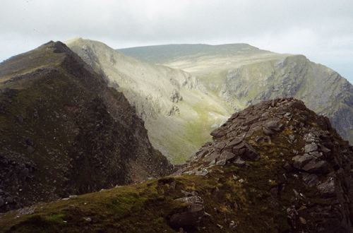
Photo taken looking from near the summit of Mweelrea to the ridge above Coum Dubh on St. Stephen's Day 2000. Linkback: mountainviews.ie/summit/34/comment/256/
Read Less
Read More
djouce on Mweelrea
by djouce
2 Apr 2003
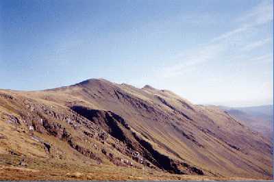
A great circuit from north of Doo Lough down to the Delphi Adventure centre. Very steep climb up west of Doo Lough. Cliffs - would be dangerous in poor visibility (see photo). Time needed - 6 to 7 hours. Great views in all directions over sea and barren landscapes. Linkback: mountainviews.ie/summit/34/comment/419/
Use of MountainViews is governed by conditions and a privacy policy.
Read general information about the site. Opinions in material here are not necessarily endorsed by MountainViews.
Hillwalking is a risk sport. Information in comments, walks, shared GPS tracks or about starting places may
not be accurate for example as regards safety or access permission. You are responsible for your safety and your permission to walk.
See the credits and list definitions.


 Our Facebook page.