Cookies.
This website uses cookies, which are small text files that the website puts on your device to facilitate operation. Cookies help us provide a better service to you. They are used to track general user traffic information and to help the website function properly.
Features
Nearby features appear when you click the map.
Declutter tracks on map.
Place Search
Video
X
Pub: by
South East Midlands Area , N Cen: Timahoe Hills Subarea
Feature count in area: 31, by county: Laois: 6, Carlow: 1, Offaly: 1, Kildare: 2, Kilkenny: 13, Tipperary: 8, OSI/LPS Maps: 28A, 28B, 47, 48, 49, 53, 54, 55, 59, 60
Highest Place: Slievenamon 720.2m

Starting Places (16) in area South East Midlands:
Ballinvarry West, Clodiagh Church, Coolnahau, Coppanagh Wood South, Freney's Well, Glynn, Gorlough Wood, Hill of Allen, Inistioge, Killamery Wood East, Kylebeg Wood, Lingaun River, Mount Alto Wood, Mullenbeg Wood South, Newtown Upper School, Slievenamon Walk Head

Summits & other features in area South East Midlands:
E: Barrow: Clogrennan Hill 336m, Newtown Hill 208m
N Cen: Timahoe Hills: Ballaghmore Hill 268m, Cullenagh Mountain 317m, Fossy Mountain 332m, Hewson Hill 261m
N: Croghan: Croghan Hill 234m
N: Newbridge Hills: Dunmurry Hill 233m, Hill of Allen 219m
S: Mullinavat: Coolnahau Hill 265m, Corbally Hill 285m, Mount Alto 276m, Tory Hill 292m
S: Slievenamon: Knockahunna 502.8m, Sheegouna 553.5m, Slievenamon 720.2m, Slievenamon North-West Top 564m
S: Windgap: Carricktriss Gorse 314m, Carrigadoon Hill 296.9m, Faranaree Hill 283m
SE: Brandon Hill: Brandon Hill 515m, Coppanagh 365m, Croghan 365m
W Cen: Durrow: Ballynalacken Hill 314m, Caponellan Hill 253m, Knockmannon Hill 315m
W Cen: Slieveardagh: Clomantagh Hill 349m, Knocknamuck 340m, Monabrogue 284m
W: Horse & Jockey: Kill Hill 241m, Killough 235m

Note: this list of places may include island features such as summits, but not islands as such.
Rating graphic.
Cullenagh Mountain, 317m Hill Sliabh Chuileannaí A name in Irish,
Place Rating ..
(poss. Ir. ‡Sliabh Chuileannaí [PDT], 'mountain of Cuileannach or
place of holly')
, Laois County in Leinster province, in Binnion Lists, Cullenagh Mountain is the 1120th highest place in Ireland.
Grid Reference S49855 89565, OS 1:50k mapsheet 60
Place visited by: 32 members, recently by: Moirabourke, Arcticaurora, moggy40, SenanFoley, markwallace, melohara, ceadeile, conormcbandon, DeltaP, Dessie1, chalky, eannanilamhna, wwwalker, Fergalh, jlk
I visited this place: NO (You need to be a logged-in member for this.)
Longitude: -7.258936, Latitude: 52.954878, Easting: 249855, Northing: 189565, Prominence: 152m,  Isolation: 6km, Has trig pillar
ITM: 649795 689601
Bedrock type: Thick flaggy sandstone and siltstone, (Bregaun Flagstone Formation)
Notes on name: Cullenagh Mountain is the highest of a group known as the Slieve Lough Hills or Dysart Hills. On the northern edge of this range is the Pass of the Plumes (Ir. Bearna na gCleití), site of a famous battle in 1599, in which the O'Moores of Leix routed the forces of the Earl of Essex.
  Short or GPS IDs, 6 char: ClngMn, 10 char: ClnghMntn

Linkback: https://mountainviews.ie/summit/936/
Gallery for Cullenagh Mountain (Sliabh Chuileannaí) and surrounds
No summary yet for this place .
Member Comments for Cullenagh Mountain (Sliabh Chuileannaí)
Comment create / edit display placeholder

New Lovely walk with nice views.
by Arcticaurora 21 Apr 2024
Started from the forestry barrier at A (S483 901). Yesterday was my 2nd time there. Followed the path around and where the path became overgrown we entered the forestry and picked up a wellmarked trail there, possibly used by bikes. Plenty of space to walk between the trees to eventually reach the Trig. Linkback: mountainviews.ie/summit/936/comment/24174/
Read Less
Read More

            MountainViews.ie picture about Cullenagh Mountain (<em>Sliabh Chuileannaí</em>)
Picture: Trig Cullenagh Mountain April 2019
April 2019 update
by ceadeile 29 Apr 2019
Cullenagh Mountain April 2019
From forest entrance at B (S48462 90374) walk along the track, first tending North East then curving round to tend South East.
After 1 km from the start you reach a junction in the tracks at C (S49331 90428).
At this junction head South, gently uphill, along a good track for 460 metres to where there is another junction.
Take the left fork and continue straight uphill SSE (approx. 160 degrees) for around 525 metres (the fork to the right leads to the Communications Towers)
The track now begins to tend East, then North then curves around South again becoming grassy and a little mucky as you ascend.
You eventually come to a small clearing near the summit at D (S49907 89629).
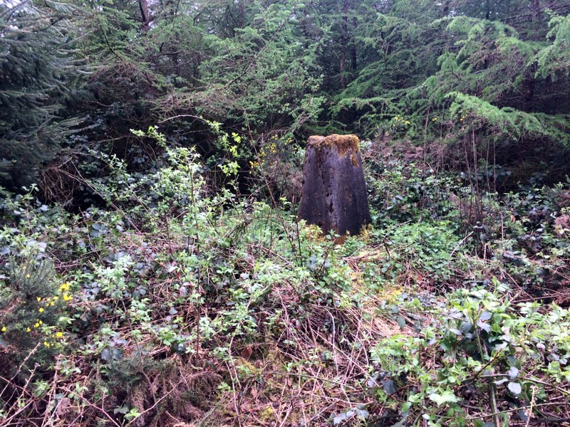
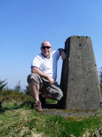
You then have to dive into the trees, on a bearing of approx. 200 degrees, for 80/90 metres to reach the trig pillar at E (S49855 89565).
The line of the tree planting has, thankfully, made these last 80 / 90 metres reasonably easy to negotiate.
You may have to crouch but you should not have to resort to crawling on your hands and knees.
The trig pillar area is located in a small clearing and the light from this clearing, reaching faintly into the forest, will help you locate it.
The ground around the trig pillar has a healthy growth of briars and nettles but is still a welcome sight.
You can return to the start by the same route or, alternatively, on returning the last 80 / 90 metres to the clearing, head South down the grassy muddy track to reach a good gravelled track at F (S49859 89314).
By then turning left (East) and descending on this good track tending NNE, past a quarry on your left, and heading NW after crossing an earth barrier across the track at a junction at G (S50060 89920), about 550 metres from the quarry,
and following this track as it curls round to the west then crossing a bridge over a stream at H (S49355 90406), eventually arrive back at the junction mentioned above (B) just 1km from the start. Linkback: mountainviews.ie/summit/936/comment/20505/
Read Less
Read More

            MountainViews.ie picture about Cullenagh Mountain (<em>Sliabh Chuileannaí</em>)
Picture: View of Wicklow Mountains from near Summit.
peterturner on Cullenagh Mountain
by peterturner 15 Jun 2009
Small place but wonderfully situated. Views of the entire Wicklow Range, the Blackstairs, the Slieve Blooms and more. I took a West to East route and ambled around for an hour and a half. Beautiful walk to do as the sun is setting and easily accesible by taking the road east from Ballyroan (marked Timahoe) and then the first left up a small road straight into the forest and parking about 500m in at a truck turning point on the right. I recommend checking the aerial photo provided by OSI mapviewer as the Discovery map does not show the forest tracks correctly. For anybody else wishing to add this to their tally the route briefly is as follows: From the parking point head further along the track until you come to an right turn curving uphill. Climb steadily and follow the track around to the left until you reach a set of masts. Past the masts head downhill on the same track until you reach a junction and turn sharply right. Follow this track ignoring the turn to the left downhill a short way along for now although this will be your route back. Nearing the conclusion of the track about ten minutes later you are greeted with ever expanding views of the entire Eastern mountain uplands including all of Wicklow and the Blackstairs. In front of you can be seen three forested hills in Stradbally direction, Fossy Mountain and Timahoe and other hilltops can be identified elsewhere including the Eastern half of the Slieve Blooms for example. The actual summit is nearly impossible to locate as it is buried in (June 2009) tussocky grass and a close coniferous plantation however the view is better from the top of the forest track anyhow due to the trees. Retrace your steps back to that turn (now to your right) downhill and follow this steadily downhill for another ten minutes until you reach a junction where you turn left and shortly after left again. This brings past the sound a small stream trickling in a fairly deep gorge considering its size and a crossroad of forest tracks. Head straight through the crossroads onto the straight level path and return to your starting point. The walk is entirely on a forest track and only requires a comfortable pair of shoes really unless you head off track. Quite a lot of forest felling and new plantation was going on at the time of writing. Linkback: mountainviews.ie/summit/936/comment/3854/
Read Less
Read More

            MountainViews.ie picture about Cullenagh Mountain (<em>Sliabh Chuileannaí</em>)
Picture: Cullenagh trig pillar
Cullenagh Mountain
by waldobk 18 Apr 2010
This is possibly the shortest route up to the summit.

Start from A (S483 901) (Point A) , a road barrier will prevent you from driving further into the forest. Continue on until you come to a crossroads, at this point you turn right and proceed to walk uphill. At the next junction take the track the branches off to the left , Stay on this track ignoring the turn off to the left . As you continue on the forest becomes less dense. You will eventually reach a small clearing. Continue forward along a narrow path and after about 20 metres you will have reached the trig pillar. The only difficult part of this trek was the last 20 metres .

I climbed this on 17th April 2010. It was a sunny day but the views were very hazy , this was possibly due to the volcanic ash in the atmosphere from the volcanoe in Iceland. Linkback: mountainviews.ie/summit/936/comment/4636/
Read Less
Read More

Briars
by aidand 2 Mar 2012
After a forest is clear felled the briars move back in anxious to make up for the time lost in the shade of the forest. The newly planted trees gradually grow up and compete with the briars making the plantation virtually impassable. This is the state of the summit of Cullenagh. Follow the advice given below and you will get to about 100 metres from the top. Then the 'fun' begins. I recommend a machete.
Alas, the views from the top are quickly disappearing behind the trees. Linkback: mountainviews.ie/summit/936/comment/6703/
Read Less
Read More
EDIT Point of Interest
text
Videos
(none available)
Recent Contributions
x
Conditions and Info
Use of MountainViews is governed by conditions and a privacy policy.
Read general information about the site.
Opinions in material here are not necessarily endorsed by MountainViews.
Hillwalking is a risk sport. Information in comments, walks, shared GPS tracks or about starting places may not be accurate for example as regards safety or access permission. You are responsible for your safety and your permission to walk.
See the credits and list definitions.

OSi logo
OSNI/LPS logo
Open Street Map
(Various variations used.)
British summit data courtesy:
Database of British & Irish Hills