Donation Request 2024

DONATE
Members and Supporters, the MountainViews Committee requests your help to meet the costs of the website and of other activities such as insured events or publications.
You do not have to be logged in to donate.
Features
Nearby features appear when you click the map.
Declutter tracks on map.
Place Search
Video
X
Pub: by
Dartry Mountains Area , NE: Arroo Keeloges Subarea
Feature count in area: 31, by county: Leitrim: 22, Sligo: 10, of which 1 is in both Sligo and Leitrim, OSI/LPS Maps: 16, 17, 25, 26
Highest Place: Truskmore 647m

Starting Places (22) in area Dartry Mountains:
Aghavoghil Middle, Arroo Trail CP, Ballaghnatrillick, Ballintrillick Forest, Barrs East, Castletown, Crumpaun, Curraghan Road, Dough Mountain NW, Dough Mountain West, Drumcliff River Road, Eagles Rock, Edenbaun, Glencar Waterfall, Gleniff Horseshoe Road, Lough Cloonaquin North, Luke's Bridge, Mountain Wood, Poulveha River, Thur East, Tormore Car Park, Truskmore Transmitter Entrance

Summits & other features in area Dartry Mountains:
N: Truskmore: Gortnagarn 445m, Tievebaun 611m, Truskmore 647m, Truskmore SE Cairn 631m
NE: Arroo Keeloges: Aganny Top 482m, Aghalateeve 432m, Agow Top 423m, Arroo Mountain 523m, Conwal North 421m, Crocknagapple 372m, Keeloges 452m
NW: Benbulbin: Annacoona Top 597m, Benbulbin 526m, Benwiskin 514m, Benwiskin South Top 508m, Kings Mountain 462m
SE: Manorhamilton Hills: Ballaghnabehy Top 413m, Benbo 415m, Dough Mountain 462m, Lackagh Mountain 449m, Larkfield 305m, Naweeloge Top 441m, Thur Mountain 442m
SW: Castlegal Hills: Copes Mountain 452m, Crockauns 463m, Hangmans Hill 400m, Keelogyboy Mountain 438m, Keelogyboy Mountain Far East Top 418m, Keelogyboy Mountain NE Top 435m, Keelogyboy Mountain SW Top 417m, Leean Mountain 417m

Note: this list of places may include island features such as summits, but not islands as such.
Rating graphic.
Aganny Top, 482m Hill
Place Rating ..
, Leitrim County in Connacht province, in Carn Lists, Aganny Top is the 621st highest place in Ireland.
Grid Reference G84431 49029, OS 1:50k mapsheet 16
Place visited by: 32 members, recently by: Colin Murphy, annem, conormcbandon, supersullivan, markmjcampion, magnumpig, FrankMc1964, PaulNolan, Wildrover, melohara, PeakPaul, Hilldweller, frankmc04, Wilderness, madfrankie
I visited this place: NO (You need to be a logged-in member for this.)
Longitude: -8.240429, Latitude: 54.389641, Easting: 184431, Northing: 349029, Prominence: 37m,  Isolation: 2.2km
ITM: 584384 849029
Bedrock type: Pale orthoquartzitic sandstone, (Glenade Sandstone Formation)

  Short or GPS IDs, 6 char: AgnyTp, 10 char: Aganny Top

Linkback: https://mountainviews.ie/summit/507/
Gallery for Aganny Top and surrounds
Summary for Aganny Top : A somewhat remote top.
Summary created by Harry Goodman 2011-11-16 15:39:01
            MountainViews.ie picture about Aganny Top
Picture: View N over L Aganny from the unmarked, uninspiring high point.
Route 1:On the R280 go E A (G796 515) along a minor road to a sharp bend left. A lane on the right B (G801 515) is the access route. In May 2010 a notice indicated "Private Road - No Entry" It is likely that this relates to vehicles and not walkers but permission to walk up should be sought at one of the houses near the start. The lane soon becomes an unsurfaced track that leads up towards and around the N end of the Keeloges escarpment. At C (G823 504) (3k along) leave the track and go SE up the heathery slopes for 1.7k to a standing stone D (G83938 50070) on the long N to S ridge from Arroo Mt. to Aganny Top. Turn right and go S over Pt 453 E (G840 495) and then further on to a large cairn F (G84477 49032) above and to the N of Lough Aganny. The high point of the hill, Pt 482 still lies some 300m away to the S side of the lough at G (G84450 48751), is unmarked and undistinguished in any way on the flat heathery moorland. The walk up and back is 12k. Route 2: On a minor road (L2127) off the R 280 take another minor road NE H (G864 434). Park with consideration at I (G871 442) and walk N going left at a Y junction. At J (G872 455) go NNW uphill past an old sheep pen to Pt 423 (Agow Top) K (G865 472). Aganny Top lies some 2.8k NW further along past the S tip of L Nabrack L (G858 475). Out and back is 12.5k with the advantage of bagging Agow Top on way.
Linkback: mountainviews.ie/summit/507/comment/5266/
Member Comments for Aganny Top
Comment create / edit display placeholder

            MountainViews.ie picture about Aganny Top
Picture: The deep gully
New Approach from SW
by Colin Murphy 12 Apr 2024
An alternative approach is from the SW, starting at M (G81484 47541), where there is just about room to squeeze a car without blocking the track. Go along the farm lane and cross a gate, and follow the gently rising track for about 2.5km as it curves up and around the eastern side of Aghlateeve, affording views of a deep gully in the right and Glenade Lough to the south. The track finally peters out at N (G82907 48089). This takes you to about 270m elevation and leaves you 1.5km from the summit. Unfortunately it gets tough after that, as 1km of the ascent is through deep, leg-wearying heather, some of the slope steep. Eventually you emerge on to the broad summit area, which is a mix of rocks and grass. Linkback: mountainviews.ie/summit/507/comment/24177/
Read Less
Read More

            MountainViews.ie picture about Aganny Top
Picture: Looking N to Arroo Mt from large cairn near the summit of Aganny Top
Worth visiting as part of a round of other tops
by Harry Goodman 8 Jun 2010
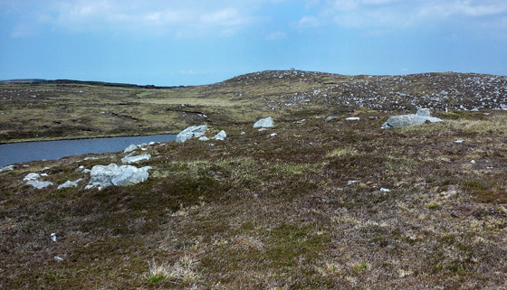
Climbed Aganny Top on Saturday 22 May 2010 as the second hill in a round that also included Arroo Mt, Agalateeve and Keeloges. (For first part of the route see my comments on Arroo Mt.) The walk out to Aganny Top from Arroo Mt is some 3km through, around and over a series of small peat hagged tops, some with a cairn. On the day we were there it was fine and clear so route finding was not a problem. However in poor visability it would be very easy to become disoriented and use of map and compass, backed up by a GPS, would be essential. From the top of Arroo Mt we made our way S to a cairn on a small rise overlooking Lough Arroo O (G83647 50768) and then around the W (right) side of the Lough. Having noted a standing stone marked on the OSI map and, as it was more or less en route, we sought it out at D (G83938 50070) before heading for Lough Aganny and Aganny Top (Pt 482). Along the way we came upon a surprise find, a fully completed millstone lying undisturbed where it had been fashioned out of the rock yet there was no apparent evidence of any quarrying in the area P (G84448 49040). A little further on at 
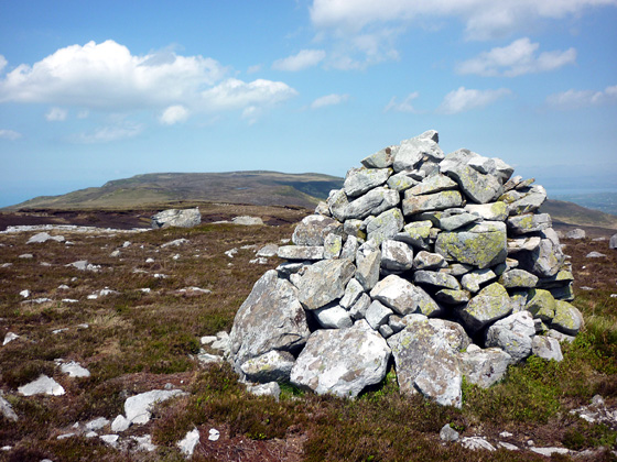
F (G84477 49032), on a raised area, was a very substantial cairn above and to the N of Lough Aganny with Aganny Top still some 300metres away on raised ground to the S across the small Lough. Strangely the spot height indicating the summit (Pt 482) is not marked by a cairn G (G84450 48751) and is completly nondescript and undistinguished in any way. Indeed looking back across the Lough to the large cairn it appeared to stand on a higher elevation than Pt 482 but perhaps this is an illusion caused by the presence of the large cairn. While we were on Pt 482 a walker came to the large cairn and, without a second glance in our direction, proceeded on his/her way clearly satisfied that the cairn marked the top of the hill. From Pt 482 we also walked a little further S to yet another small cairn at 
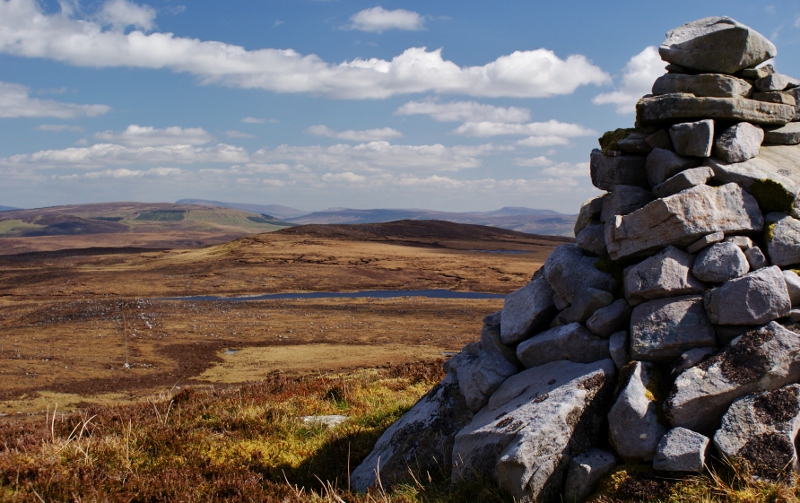
Q (G84644 48448). From this hill there are splendid views W across the long flat topped Aghalateeve to Truskmore and Tievebaun and S to the knobbly ridge of the Castegal Mountains. From here we then headed down a heathered covered slope in search of our next objective Aghalateeve. I suspect that given its location Aganny Top is a hill that not many people will seek out and climb in its own right. However it is well worth a visit as part of a round which includes some other tops. Linkback: mountainviews.ie/summit/507/comment/5840/
Read Less
Read More

            MountainViews.ie picture about Aganny Top
Picture: Last cairn before Agow Top
Bang on Top
by gerrym 26 Jan 2013
Aganny Top is bang in the middle of a wonderful plateau surrounded by steep escarpments and deep glens.
It is not too much of a stretch to complete a walk over this plateau and its 5 separate summits, which is what I did of course!

Starting from St Michaels church (R (G803 503)) and making use of the copius parking, a steep ascent brought the summit of Keeloges and stunning views across Gleanade to the neighbouring plateau with Truskmore and Tievebaun. A significant drop and reascent brings Arroo with more stunning views across Donegal Bay to the mighty Slieve League and the Bluestacks.

But back to Aganny Top.....drop from Arroo and follow the plateau as it undulates on good ground of short heather and stone, with peat hags in the shallower ground. Pass a little cairn and the remains of an old comms mast and a small unnamed lough below. A rise brings a cairn and are suddenly introduced to Arroo Lough, a beautiful and peaceful setting with shelter from a keen wind and the sound of water gently lapping. The odd fat bumblebee passing as walked the shore to cross a fence by way of a stile. Another cairn sits on a rise beyond the lough.

Followed a stream for a short time and walked easily through big peat hags to reach a beehive cairn just before Lough Aganny. As i sat in lee of the cairn in warm sun, watching the sparkling waters of the lough and the clouds getting smaller and smaller from the greyness of the morn, my eyes roved N to Arroo, Bluestacks, Slieve League rising out of the Atlantic...W to the upper halves of Tievebaun and Truskmore, the Ox Mtns and around to the Briefne Hills and the Sperrins beyond.

Another cairn lies beyond the lough and eyes seek out the drop and rise to Agow Top in the distance. A final cairn signals the drop off Aganny with lovely views over Lough Nabrack within a sea of brown. That was where i headed............ Linkback: mountainviews.ie/summit/507/comment/14911/
Read Less
Read More
EDIT Point of Interest
text
Videos

Recent Contributions
x
Conditions and Info
Use of MountainViews is governed by conditions and a privacy policy.
Read general information about the site.
Opinions in material here are not necessarily endorsed by MountainViews.
Hillwalking is a risk sport. Information in comments, walks, shared GPS tracks or about starting places may not be accurate for example as regards safety or access permission. You are responsible for your safety and your permission to walk.
See the credits and list definitions.

OSi logo
OSNI/LPS logo
Open Street Map
(Various variations used.)
British summit data courtesy:
Database of British & Irish Hills