Donation Request 2024

DONATE
Members and Supporters, the MountainViews Committee requests your help to meet the costs of the website and of other activities such as insured events or publications.
You do not have to be logged in to donate.
Features
Nearby features appear when you click the map.
Declutter tracks on map.
Place Search
Video
X
Pub: by
Slieve Mish Area , E: Barnanageehy Subarea
Feature count in area: 16, all in Kerry, OSI/LPS Maps: 71, EW-DC, EW-DE
Highest Place: Baurtregaum 849.7m

Starting Places (15) in area Slieve Mish:
Caherconree Scenic Route, Derrymore West Trail, Doonore South, Emlagh Cross, Emlagh Wood, Feighatidura Cove, Glanaskagheen Wood, Greenlawn Cross, Laharn Viewpoint, Lougher, Maum Cross, Maumnahaltora Cross, R561 Lissaroe, Tonavane Cross, Tonavane Walk Kerry Camino

Summits & other features in area Slieve Mish:
Cen: Baurtregaum: Baurtregaum 849.7m, Baurtregaum Far NE Top 601.2m, Baurtregaum NE Top 818.5m, Baurtregaum NW Top 723m, Caherconree 835m, Castle Hill 600m, Gearhane 792m
E: Barnanageehy: Barnanageehy 561m
W: Aughils: Beenduff 515m, Caherbla 585.2m, Emlagh 483m, Knockbrack 459m, Knockmore 565m, Lack Mountain 465m, Moanlaur 566m
W: Camp: Corrin 332m

Note: this list of places may include island features such as summits, but not islands as such.
Rating graphic.
Barnanageehy, 561m Mountain Bearna na Gaoithe A name in Irish,
Place Rating ..
(prob. Ir. Bearna na Gaoithe [PDT], 'gap of the wind'), Kerry County in Munster province, in Arderin Lists, Barnanageehy is the 390th highest place in Ireland. Barnanageehy is the most easterly summit and also the second most northerly in the Slieve Mish area.
Grid Reference Q80052 08239, OS 1:50k mapsheet 71
Place visited by: 75 members, recently by: maoris, CusackMargaret, johncusack, a3642278, peter1, Taisce, chelman7, Moses, eiremoss34, annem, mh400nt, Ulsterpooka, nesa1206, jackos, Bunsen7
I visited this place: NO (You need to be a logged-in member for this.)
Longitude: -9.75541, Latitude: 52.21308, Easting: 80052, Northing: 108239, Prominence: 56m,  Isolation: 3.3km
ITM: 480041 608265
Bedrock type: Purple cross-bedded sandstone, (Cappagh Sandstone Formation)
Notes on name: This is one of the most common names for a pass in Ireland. The name is actually marked on lower peaks to the E, and it seems likely that the gap in question is even further to the E.
  Short or GPS IDs, 6 char: Brnngh, 10 char: Brnnghy

Linkback: https://mountainviews.ie/summit/339/
Gallery for Barnanageehy (Bearna na Gaoithe) and surrounds
Summary for Barnanageehy (Bearna na Gaoithe): A long easy ascent from the roadside
Summary created by Colin Murphy, jackill 2014-05-29 18:55:11
            MountainViews.ie picture about Barnanageehy (<em>Bearna na Gaoithe</em>)
Picture: Summit stones
Start at Quarry Hill car park A (Q83642 07816) ,room for many cars and walk uphill and west on a track initially. It should be noted that half way up this track you encounter a locked gate with a big yellow 'Restricted Access' sign. The track continues past various aerials and power supply buildings and ends at open hillside. If you have any concerns regarding using this track, there is pretty open access to the hillside just past the start of the track. After that you will have a little over an hour's walk to the summit, heading directly west for 3km until the last 500m when you veer slightly NW. The climb is fairly gentle (the starting point is already at 300m), crossing a number of rolling hills, none of which are much of a challenge. Going underfoot is mostly firm, a mixture of long grass and some heather. The unremarkable summit is marked by a pile of rocks. 2.5 hours to top and back.
Linkback: mountainviews.ie/summit/339/comment/5099/
Member Comments for Barnanageehy (Bearna na Gaoithe)
Comment create / edit display placeholder

            MountainViews.ie picture about Barnanageehy (<em>Bearna na Gaoithe</em>)
Picture: Looking north to the Reeks
Great long range views in clear weather
by Bunsen7 22 Jul 2021
Enjoyed a walk to this summit on a stunningly clear day. The route from the east is a little tedious but is rewarded in clear weather. The "popular" startpoint beside the telecoms antennae can be found on google maps as "Laharn Viewpoint".

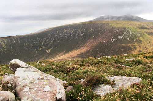
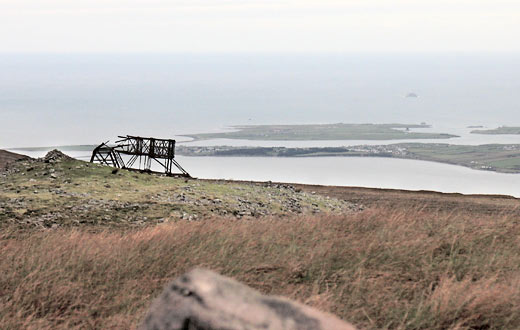
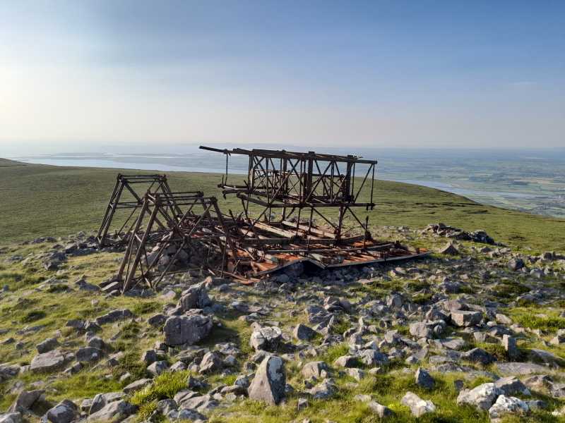
I can understand the source of the name of this summit as just to the northwest of the summit proper, at the location of the decaying Iron Man, there's a gap of sorts between tops where wind funnels up from the valley to the south. This valley has some handsome steep-sided cliffs on its western flank.
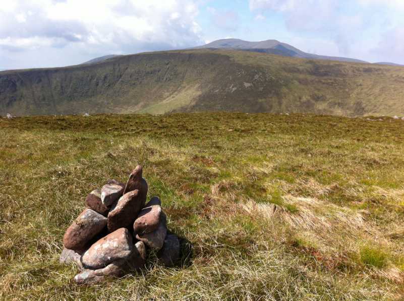
At this spot B (Q79898 08395) , where a cairn has been assembled, you can enjoy great views both North and South, and ponder how the enterprise that built the Iron Man is somehow able to leave it rotting on this hillside without any obligation to retire its asset. Thankfully more modern legislation on such constructions should require modern telecoms masts to be disassembled at the end of their useful lives, with the ground "made good". Well, we live in hope anyway.

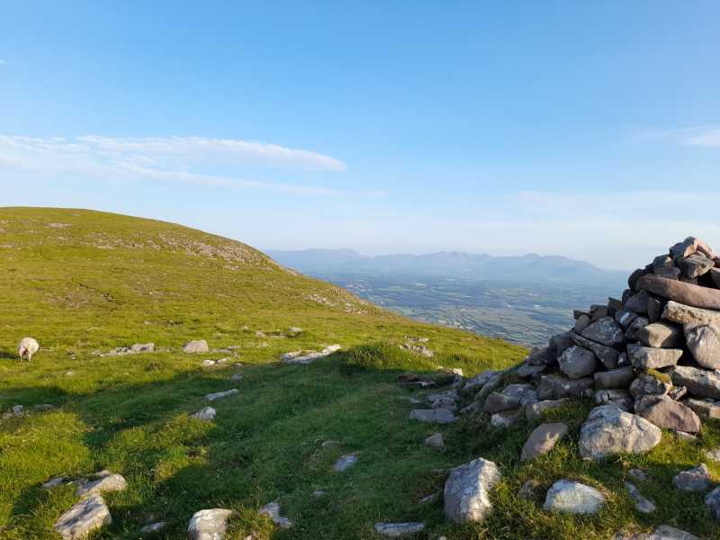
On the day that was in it, I could comfortably make out all the major tops of the Reeks to the south, as far as the Paps to the East, and at times on my route I could see Kells Mountain to the south west. Of course, turning to face northwards I could also benefit from a glorious vista across North Kerry, easily picking out some of the Tralee landmarks such as the Blennerville Windmill and the Tralee Canal, beyond then to Ballyheighue and Kerry Head, as well as the outline of Loop Head in County Clare in the far distance.

Typical of North Kerry, no effort is made by the authorities to promote the Slieve Mish as any sort of tourist attraction, and this hill is less enticing than others, so you'll almost certainly have this place to yourself. Linkback: mountainviews.ie/summit/339/comment/23217/
Read Less
Read More

            MountainViews.ie picture about Barnanageehy (<em>Bearna na Gaoithe</em>)
Picture: View to the west of the summit.
simon3 on Barnanageehy
by simon3 15 Dec 2005
Barnanageehy surely must be near enough for a resident of Tralee, or at least Blennerville, to reach on foot without difficulty. One way of getting there is to walk south of Blennerville towards C (Q816 103) where the tarmac road stops and a dirt track starts. Follow this up to some traditional bog workings which, as of Nov 2005, were in use. Some interesting bog wood has been exposed there incidentally. Looking over Tralee the wind power station on Stack's mountain is very visible. Many of us believe that we need windpower and that this relatively low site is appropriate. However , it also gives an indication of what we may see in future if proposed developments in places such as Meenteog/ Coomacarrea on the Iveragh peninsula are implemented. That ridge is at 700m and is clearly visible from the Slieve Mish area.

Barnanageehy turns out to be just slightly the highest bump on a ridge that extends from East to West eventually joining up with Glanbrack Mountain, a long easterly spur off Baurtregaum and almost a summit in its own right.

The photo shows Barnanageehy's mini cairn with Baurtregaum on the skyline to the right. Linkback: mountainviews.ie/summit/339/comment/2083/
Read Less
Read More

            MountainViews.ie picture about Barnanageehy (<em>Bearna na Gaoithe</em>)
Picture: Monstrosity near the summit.
simon3 on Barnanageehy
by simon3 6 Jan 2006
Just over 200m to the NW lies the decaying metalwork of a microwave reflector, unfortunately obscuring the otherwise great view towards Fenit. According to Sean O Suilleabhain [Irish Walk Guides South West 1978] the was used to bounce microwave signals from Tralee to LImerick and was locally called the Iron Man. Sean recounts the safety issues encountered by some of the staff: "After the experience of having some men lose their way in fog (they had ascended the north side and descended the south side unintentionally), all staff members now leaving Tralee are provided with a compass and a list of compass bearings between the poles which were erected along the route,..." There's only a few of the poles left and it is interesting to clarify how they got there. Linkback: mountainviews.ie/summit/339/comment/2084/
Read Less
Read More

The Iron Man
by gfmurphy101 6 Sep 2013
Climbed up there recently some pics I took of the 'Iron Man' and surrounds can be seen here
http://gfmurphy101.wordpress.com/2013/08/16/the-iron-man/ Linkback: mountainviews.ie/summit/339/comment/15174/
Read Less
Read More

            MountainViews.ie picture about Barnanageehy (<em>Bearna na Gaoithe</em>)
Picture: Close Up
Unsurprisingly blown down by prevailing southerly winds
by Bunsen7 22 Jul 2021
Here's a close up of the Iron Man monstrosity.

The metal has obviously rotted but I'd say the fact that it was constructed in a "windy gap" with wind funnelling up the valley from the South had something to do with it falling northwards! Linkback: mountainviews.ie/summit/339/comment/23218/
Read Less
Read More
EDIT Point of Interest
text
Videos
Recent Contributions
x
Conditions and Info
Use of MountainViews is governed by conditions and a privacy policy.
Read general information about the site.
Opinions in material here are not necessarily endorsed by MountainViews.
Hillwalking is a risk sport. Information in comments, walks, shared GPS tracks or about starting places may not be accurate for example as regards safety or access permission. You are responsible for your safety and your permission to walk.
See the credits and list definitions.

OSi logo
OSNI/LPS logo
Open Street Map
(Various variations used.)
British summit data courtesy:
Database of British & Irish Hills