Members and Supporters, the MountainViews Committee requests your help to meet the costs of the website and of other activities such as insured events or publications.
Feature count in area: 27, all in Galway,
OSI/LPS Maps: 37, 38, 44, 45, EW-CON
Highest Place: Binn idir an dá Log 702m
Starting Places (42) in area Maamturks: An Móinín Mór, Bealanabrack River Tributary, Bundorragha Estuary Cross, Cannaclossaun, Carraig Bar, Connemara Mountain Hostel, Delphi Resort, Dernasliggaun, Drehidanookera Bridge, Failmore River, Fee Lough SW, Glashmore Bridge, Glencraff Road End, Gleninagh River, Gowlaunlee Lake, Illaunroe South, Killary Boat Tour Pier W, Knocknafaughy SW, Kylemore River, Leenane, Leenane Hotel, unuseableLeenane R336, Lehanagh Lough N, Lehanagh Lough SE, Lough Fee East, Lough Nacarrigeen S, Lough Shindilla S, Maum Bridge Road Lower, Maum Bridge Road Mid, Maum Bridge Road Upper, Maumwee Lough, Nambrackkeagh Lough, Oorid Lough, Owenwee River, Pas Mám Éan CP, Rinavore East, Rinavore SW, Shanvally, Tawnabeg Lough North, Tooreennacoona River, Western Way Cnoc na hUilleann, Western Way Inagh Cottages
Summits & other features in area Maamturks: N: Leenaun: Maumturkmore 488m, Búcán 550m, Leenaun Hill 618m, Leenaun Hill Far North-West Top 556m, Lettershanbally 324m, Meall Cheo 578m, Taobh Dubh 422m N: Maumturks N Cen: Barrlugrevagh 558m, Letterbreckaun 667m, Letterbreckaun NE Top 603m, Knocknahillion 607m, Knocknahillion North Top 541m, Cúlóg 435m S: Maumturks S Cen: Binn Chaonaigh 633.5m, Binn idir an dá Log 702m, Binn idir an dá Log SE Top 659.3m, Binn Mhairg 612.4m, Knocknagur 310m S: Maumturks South: Binn Mhór 660.6m, Binn Mhór NE Top 641.2m, Binn Mhor West Top 595.8m, Binn Mhor East Top 631.3m, Lissoughter 401m, Corcogemore 610.1m, Mullach Glas NE Top 432m, Lackavrea 396m, Mullach Glas 621.3m
Note: this list of places may include island features such as summits, but not
islands as such.
Letterbreckaun NE Top, 603mMountain Binn Bhriocáin (mullach thoir thuaidh) A name in Irish,
Place Rating ..
For origin of name, see Letterbreckaun / Binn Bhriocáin., Galway County in Connacht province, in Arderin Beg, Vandeleur-Lynam, Irish Best Hundred Lists, Binn Bhriocáin (mullach thoir thuaidh) is the 276th highest place in Ireland.
Grid Reference L86166 55442,
OS 1:50k mapsheet 37 Place visited by: 247members, recently by: Jimmy600leavey, TipsyDempy, Blackstar, Padraigin, taramatthews, PiotrR, maoris, SeanPurcell, Prem, Carolineswalsh, NualaB, ToughSoles, Ansarlodge, Kaszmirek78, Barrington1978
I visited this place: NO (You need to be a logged-in member for this.)
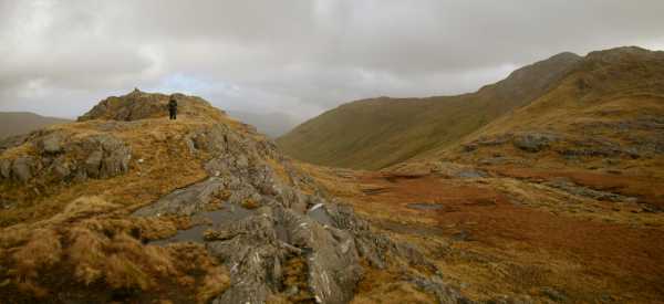
Heading for the gap at Maumturk/Holy Well from Binn Bhriocain (Letterbreckaun) the ideal route is to head for the col close to Binn Bhriocain-NE Top. From Binn Bhriocain-NE Top the ridge descends in a north/north westerly direction heading for the gap. Clear navigation and route finding particularly in misty conditions is required as there is steep ground in the vicinity and a lack of defined features on the ground. Linkback: mountainviews.ie/summit/264/comment/1410/
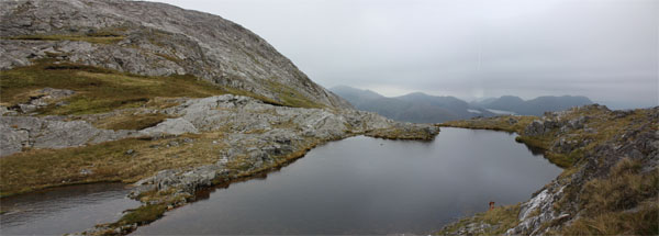
Picture: Th view towards Killary from near the summit of Binn Bhriocáin NE Top
Great views
by csd
26 Sep 2010
I came to Binn Bhriocáin NE Top from the main summit itself. On the way you'll come across this little pond, with great views over towards Killary. Linkback: mountainviews.ie/summit/264/comment/6112/
Read Less
Read More
Picture: Gowlaun
Gowlaun - The Northern Turks
by aburden
28 Feb 2011
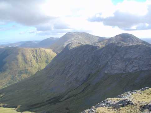
Binn Bhriocain NE top can be seen as the 'pointy' top to the right of the photo. As you descend from Letterbreckaun to the Holy Well you - should - pass several ( freshly re-stacked ) cairns that lead you onto grassy bog and onto the small cairn the walker shown is arriving at. From here, a bearing of circa. NNE will get you to the Well in time for the steep onward climb to Maumturkmore. Linkback: mountainviews.ie/summit/264/comment/6254/
Use of MountainViews is governed by conditions and a privacy policy.
Read general information about the site. Opinions in material here are not necessarily endorsed by MountainViews.
Hillwalking is a risk sport. Information in comments, walks, shared GPS tracks or about starting places may
not be accurate for example as regards safety or access permission. You are responsible for your safety and your permission to walk.
See the credits and list definitions.


 Our Facebook page.