Members and Supporters, the MountainViews Committee requests your help to meet the costs of the website and of other activities such as insured events or publications.
Feature count in area: 20, all in Kerry,
OSI/LPS Maps: 70, 78, 83, EW-R
Highest Place: Coomacarrea 772m
Starting Places (24) in area Glenbeigh Horseshoe: Ballaghasheen Coilte, Ballaghasheen Pass Viewpoint, Cahernaman, Caunoge Boreen, Cloon Lough NE, Cloon Lough SE, Coolnahornan Bridge, Coomaclarig Bridge, Coomaglaslaw Outflow, Coomasaharn Lake, Coosatemple Cove, Coulagh Bridge Road, Drung Hill Layby, Gleensk Forest, Gleensk Viaduct, Glenbeigh Village, Lissatinnig Bridge Boreen, Lough Brista Wood, Lough Cappanlea OEC, Lough Caragh SW, River Behy Road, River Ferta Source, River Owroe Source, Roads Lough
Summits & other features in area Glenbeigh Horseshoe: Cen: Glenbeigh Horseshoe: Been Hill 651m, Beenmore 660m, Beenreagh 495m, Coomacarrea 772m, Drung Hill 640m, Keamconneragh 593m, Macklaun 607m, Meenteog 715m, Mullaghnarakill 665m, Teeromoyle Mountain 760m N: Glenbeigh: Callahaniska 219m, Coolroe 414m, Curra Hill 275m, Seefin 493m S: Caunoge: Caunoge 502m S: Knocknagapple: Colly 679m, Knocknagapple 466m, Knocknagapple NW Top 458m, Meenteog South-East Top 565m W: Mount Foley: Mount Foley 355m
Note: this list of places may include island features such as summits, but not
islands as such.
Drung Hill, 640mMountain Cnoc Droinge A name in Irish,
Place Rating ..
(Ir. Cnoc Droinge [UR*], ‘hill of the throng/assembly’), Kerry County in Munster province, in Arderin, Vandeleur-Lynam, Irish Best Hundred Lists, Drung Hill is the 218th highest place in Ireland.
Grid Reference V60277 87804,
OS 1:50k mapsheet 78/83 Place visited by: 179members, recently by: rhw, orlaithfitz, maoris, Carolineswalsh, ToughSoles, SeanPurcell, Beti13, Krzysztof_K, markwallace, amacsweeney, bagoff, bryanmccabe, farmerjoe, nammona, Oscar-mckinney
I visited this place: NO (You need to be a logged-in member for this.)
Longitude: -10.036411, Latitude: 52.02508, Easting: 60277, Northing: 87804,
Prominence: 35m, Isolation: 1.2km, Has trig pillar
ITM: 460253 587855 Bedrock type: Purple sandstone & siltstone, (Ballinskelligs Sandstone Formation) Notes on name: A fair was held regularly on Drung Hill (Barrington, 'Discovering Kerry', p. 267), which would account for the throng. There is another hill of the same name near Lauragh on the Beara Peninsula. Barrington connects Drung Hill in Iveragh with the 'kingdom of Drung', which apparently paid a tribute of thirty oxen to Cashel. Leacht Fhionáin on Drung Hill is the reputed grave of St. Fionán. It is not at the summit, as marked on the Discovery map, but on a knoll halfway down the N. slope. The penitential station and well were visited on the last Sunday of July (MacNeill, 'The Festival of Lughnasa', pp. 134-37).
Short or GPS IDs, 6 char: DrngHl, 10 char: Drung Hill Linkback: https://mountainviews.ie/summit/211/
Gallery for Drung Hill (Cnoc Droinge) and surrounds
Summary
for Drung Hill (Cnoc Droinge):
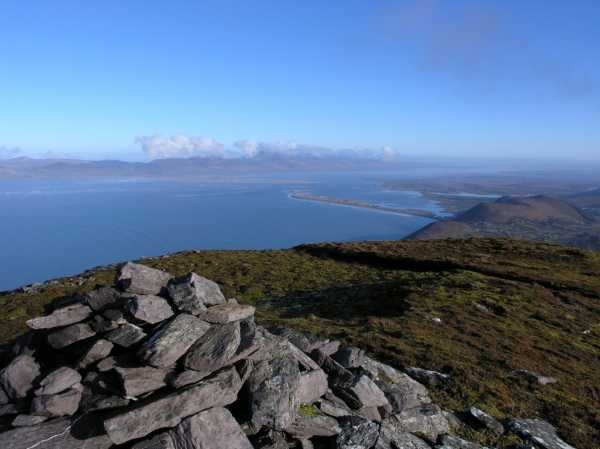
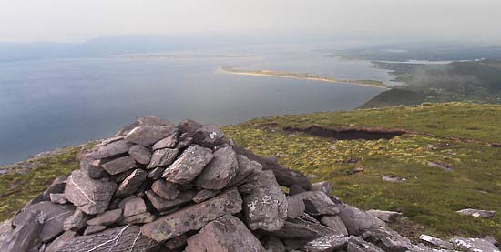
Viewpoint for Glenbeigh and the sea.
Summary created by simon3, jackill
2012-07-25 21:22:08
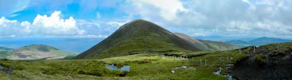
Picture: Looking to Drung from the col with Beenmore
Park off the N70 at A (V61989 88645), where the is room to park 3 cars on the roadside.
Walk west for 100 meters and follow the waymarked way sign up a track left at B (V61854 88672).
You will pass a house, an abandoned van and a disused farmyard as well as going through several gates until you reach C (V60705 88690). Cross the fence and head straight uphill to the summit of Drung Hill.
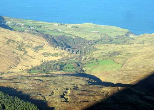
Picture: Viaduct on the old Glenbeigh to Caherciveen railway viewed from Drung hill
johnvbrennan on Drung Hill
by johnvbrennan
31 Jan 2006
I followed the same route up to Drung Hill as Roadie. Parked the car on a small byroad (ref Drung Lby (V616 888)), just off the N70 (Glenbeigh to Caherciveen road). After leaving the car, we initially walked south east for about 0.25km and picked up the Kerry Way at D (V619 887). This part of the Kerry way follows along by the coastline and it's not long before you are looking down on Rossbeigh beach, Inch strand and Dingle Bay. We approached Drung hill from the western side. While it's not very high it is pretty steep for the last 10 minutes before you reach the trig point and it certainly got the pulse going. I was very fortunate to have a very clear, sunny spring day for this walk which consisted of Been Hill, Beann Mor, Mullaghnarakill, Coomacarrea Tooth, TeerMoyle, Coomacarrea and Meentog. Linkback: mountainviews.ie/summit/211/comment/2158/
Read Less
Read More
Picture: Rossbeigh beach from Drung Hill
riverlaune on Drung Hill
by riverlaune
12 Mar 2010
I climbed Drung Hill for the first time on 16/1/10 on a beautiful frosty morning! I parked the car just off the N70(ref. Drung Lby (V61719 88788)) on a small byroad and followed the sign for the Kerry Way for a 100m or so. Then I picked up the Kerry Way at ref. E (V61886 88707), just past a small cottage and headed upward towards Drung Hill. There are many gates to pass through but eventually you come to a gate at F (V60738 88728) with a sheepwire fence that heads in the general direction of the summit. I followed this fence as far as it went and then scrambled up rock hard heather to a small plateau, with a further 30 minutes or so climb to the summit! There is a cairn and a trig. point at the top. My GPS(a new toy for Christmas - SatMap!) gave the trig. point at G (V60272 87800) - which corresponds to Simon's mountain list! From Drung Hill I walked the ridge to Beenmore(660m) but ran out of time for Been Hill(651m). I took a different route back to the car which involved following a sheep wire fence down the mountain starting on the ridge between Drung Hill and Beenmore. I would not do this again as I was hanging off it most of the way down and shredded my gloves in the process! I then picked up the Kerry way back to the car. The walk unbelievably took 6 hours at a leisurely pace and I saw only one person all day and that was on the Kerry Way! Linkback: mountainviews.ie/summit/211/comment/4387/
Read Less
Read More
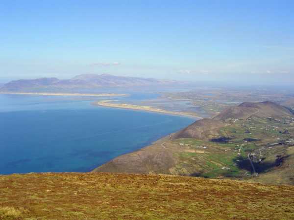
Picture: Sandspits of Rossbeigh & Inch, Barr Tri gCúm and Caherconree From Drung
Cnoc Droinge
by ciarraioch
26 Nov 2011
Drung presents a pleasing conical appearance as one approaches from the north east. Easily accessible off the Ring of Kerry road a few miles south of Glenbeigh. Park along the old road that parallels the new road and join the Kerry Way at H (V618 886) following the very scenic 'Mountain Stage' to the top of the pass. From here swing up the slope for a steep, but pretty dry ascent. Due to its height at 2100 ft and prominence, its views across Dingle Bay are hard to beat. Linkback: mountainviews.ie/summit/211/comment/6635/
Read Less
Read More
roadie on Drung Hill
by roadie
12 Sep 2003
My wife and I are heading for our mid-forties but we are very active and since last year we have taken to hill-walkingmountain climbing. We have a holiday home on the Iveragh Penin. and recently we decided to tackle Drung Hill and continue along the horseshoe ridge to finish up at Coomasahran lakeshore. We set out at 10am in generally good weather conditions (high cloud, sunny spells and light winds). To get onto the mountain we had to walk along a narrow boreen for a half-mile then turn right into a field and follow upward to where the heather started at the base of the mountain. From here on it was generally an easy climb following a slight pathway up the edge of the mountain until the steep final quarter- mile to the summit. Once there the view was spectacular: across Dingle Bay, the Blaskets, Rossbeigh Beach, Caherciveen and the other numerous mountains in the area. We began to continue our walk to Beenmore but the weather changed dramatically and with reduced visibility we decided to play it safely and return to Drung Hill and descend.What we did was a great experience and when the weather permits we will return to complete the horseshoe another day. Linkback: mountainviews.ie/summit/211/comment/636/
Read Less
Read More
Picture: Purple stones, yellow sand.
simon3 on Drung Hill
by simon3
28 Aug 2005
Lit by reddening evening sun, Drung affords views north towards the beach at Rossbeigh. As Roadie says in another comment, there's views towards Cahirsiveen and much of the Dingle Peninisula. Linkback: mountainviews.ie/summit/211/comment/1918/
Use of MountainViews is governed by conditions and a privacy policy.
Read general information about the site. Opinions in material here are not necessarily endorsed by MountainViews.
Hillwalking is a risk sport. Information in comments, walks, shared GPS tracks or about starting places may
not be accurate for example as regards safety or access permission. You are responsible for your safety and your permission to walk.
See the credits and list definitions.


 Our Facebook page.