Members and Supporters, the MountainViews Committee requests your help to meet the costs of the website and of other activities such as insured events or publications.
Feature count in area: 115, by county: Wicklow: 108, Kildare: 4, Wexford: 2, Carlow: 3, of which 1 is in both Wexford and Wicklow, of which 1 is in both Carlow and Wicklow,
OSI/LPS Maps: 28B, 55, 56, 61, 62, AWW, EW-DM, EW-LG, EW-WE, EW-WS
Highest Place: Lugnaquilla 924.7m
Starting Places (205) in area Wicklow: 1916 Memorial Car Park, Aghavannagh Ow Bridge, Aghowle Wood, Altidore Wood Entrance, Annacurra National School, Annalecka Bridge, Asbawn Brook L8350, Aughrim National School, Ballard Road, Ballinabarny Gap, Ballinagappoge Bridge Layby, Ballinagappoge Mountain Hairpin, Ballinagore, Ballinahinch Wood, Ballinastoe MBT CP, Ballinastraw South, Ballineddan Upr Fork, Ballinfoyle Upr Cross, Ballycoog, Ballycreen Brook Bridge, Ballycumber, Ballycumber Bridge, Ballycumber Lane, Ballycumber Wicklow Way, Ballylerane, Ballylow Bridge, Ballylusk Quarry, Ballymanus Lane, Ballymoyle Shooting Lodge, Ballynultagh Gap, Ballynultagh Lane, Ballyreagh Wood, Ballyross Forest, Ballysmuttan Long Stone, Baravore, Barnbawn South, Barranisky North, Barranisky West, Bohilla Land Roundabout, Bohilla Lane Mid, Boranaraltry Bridge, Bray Harbour, Brewel West, Brittas Bay North CP, Buckroney Sand Dunes CP, Bus Terminus, Camera Hill Track Cross, Castletimon Wood North, Clara Vale, Clone House Road, Clonegal, Cloon Wood Cp, Coate Bridge, Coolballintaggart Ledge, Coolbawn House Lane, Cransillagh Brook , Crone Wood CP, Crossbridge, Crossoona Rath, Cummer Wood South, Curtlestown Wood CP, Deputy's Pass CP, Derralossary Church, Derry River Bridge, Devil's Glen CP, Devil's Glen Wood, Djouce Wood Calary, Djouce Wood Lake, Djouce Wood Long Hill, Donard, Donnelly's Lane Car Sales, Drumgoff Forest, Dunranhill North, Dunranhill SE, Dunranhill South, Dwyer McAllister Cottage CP, Enniskerry, Fentons Pub, Fitzsimons Park GAA, unuseableFlemings Footbridge Glen Rd, Gap Pub, Gap Road, Glen Beach CP, Glen of the Downs CP, Glenbride Lane, Glenbride Lodge, Glencree Reconciliation, Glendalough, Glenealy GAA, Glenmacnass Tonelagee CP, Glenmalure Hostel, Glenmalure Lodge, Glenmalure Waterfall, Glenview Hotel, Gowle House, Great Sugar Loaf CP, Grove Bar, Heffernans Well Wood, Hill View, Hollywood Glen, JB Malone CP, Johnnie Fox Pub, Keadeen NE trail, Keadeen Trailhead, Kevins Way Footbridge, Kilbride Army Camp Entrance, Kilcandra South, Kilcommon View, Killalongford Wood, Kilmacrea Cross Roads, Kilranelagh House Gate, Kilruddery Car Park, Kilruddery Cottages, Kings River, Kippure Bridge, Kippure Estate, Kippure Transmitter Gate, Knickeen Cross, Knocknaboley Lane Leeraghs Bog, Knocknaboley Lane Stone Cottage, Knockrath Little, Knockree west, Kyle Loop North, Lackan Wood S, Lake Dr Fraughan Brook, Lake Drive, Lake Park Cross, Lake View Pub, Laragh Free Car Park, Laragh NSch, Lead Mines CP, Liffey Bridge, Liffey Head Bridge, Lough Bray Lower, Lough Bray Upper, Lough Tay North Viewing Point, Lough Tay Wicklow Way CP, Luglass Lane L97561, Lugnagun Track, Macreddin Village, Mangans Lane, Military Road Carrigshouk Hill, Military Road Inchavore River Nth, Military Road Inchavore River Sth, Military Road NW Lough Tay, Military Road Ballyboy Bridge, Military Road Cloghoge Brook, Military Road Croaghanmoira, Military Road Fananierin, Military Road LaraghWicklow Way, Military Road Slieve Maan, Monspolien Bridge, Moortown House, Mountain Rescue HQ, Muskeagh Little Wood, Nahanagan Lough NE, Novara Avenue, Bray, Oiltiagh Brook Knickeen, Old Bridge Cross, Old Bridge Scouts , Old Wicklow Way entrance, Paddock Hill SE, Pier Gates CP, Powerscourt Waterfall CP, Putland Road, Quintagh East, Raheen Park CP, Raheenleagh East, Railway Walk CP, Rathdrum Railway Station, Rednagh Wood, Rocky Valley, Roundwood, Sally Gap, Sally Gap N, Seefin Trailhead, Seskin SE, Shankill Tributary Bridge, Shay Elliott, Sheepshanks Bridge, Shillelagh, Slievecorragh Track, Slievefoore South, Sraghoe Brook, St John's Church, St Kevins Chair, St Kevins Church, St Kevins Way R756, Stone Circle Bridge, Stookeen South, Stranahely Wood, Stranakelly Cross Roads, Tallyho, Templeboden, Tithewer, Tomcoyle L, Tomriland Wood, Toor Brook, Trooperstown Hill Access, Turlough Hill CP, Upper Lake CP, Vallymount GAA CP, Vartry Reservoir Upper, Zellers Pub
Summits & other features in area Wicklow: Cen: Glendalough North: Brockagh Mountain 556.9m, Brockagh Mountain NW Top 549.5m, Brockagh Mountain SE Top 471.7m, Camaderry East Top 677.3m, Camaderry Mountain 698.6m, Conavalla 734m, Tomaneena 682.4m Cen: Glendalough South: Carriglineen Mountain 456.6m, Cullentragh Mountain 510m, Derrybawn Mountain 476.1m, Kirikee Mountain 474.5m, Lugduff 653.2m, Lugduff SE Top 638m, Mullacor 660.7m, Trooperstown Hill 430m N Cen: Tonelagee: Carrignagunneen 561m, Fair Mountain 571.2m, Stoney Top 713.7m, Tonelagee 815.8m, Tonelagee E Top 668m, Tonelagee South-East Top 545.8m NE: Bray & Kilmacanogue: Bray Head Hill 238.9m, Carrigoona Commons East 242m, Downs Hill 372.9m, Great Sugar Loaf 501.2m, Little Sugar Loaf 342.4m NE: Djouce: Djouce 725.5m, Knockree 342.1m, Maulin 570m, Tonduff 642m, Tonduff East Top 593m, War Hill 684.8m, White Hill 631.1m NE: Fancy: Ballinafunshoge 480m, Kanturk 527.4m, Knocknacloghoge 532.4m, Luggala 593.3m, Robber's Pass Hill 508.9m, Scarr 640m, Scarr North-West Top 559.8m, Sleamaine 430m NE: Vartry: Ballinacorbeg 336m, Ballycurry 301m, Dunranhill 342m, Mount Kennedy 365.9m NW: Blessington: Carrigleitrim 408m, Lugnagun 446.2m, Slieveroe 332m, Sorrel Hill 599.5m NW: Mullaghcleevaun: Black Hill 602.2m, Carrigshouk 572.5m, Carrigvore 682.4m, Duff Hill 720.8m, Gravale 719m, Moanbane 703m, Mullaghcleevaun 846.7m, Mullaghcleevaun East Top 796m, Silsean 698m S: Aughrim Hills: Cushbawn 400m, Killeagh 249m, Moneyteige North 427m, Preban Hill 389m S: Croaghanmoira: Ballinacor Mountain 529.3m, Ballycurragh Hill 536m, Ballyteige 447m, Carrickashane Mountain 508m, Croaghanmoira 662.3m, Croaghanmoira North Top 579.5m, Fananierin 426m, Slieve Maan 547.8m, Slieve Maan North Top 546.1m S: Croghan Kinsella: Annagh Hill 454m, Croghan Kinsella 606m, Croghan Kinsella East Top 562.1m, Slievefoore 414m S: Shillelagh Hills: Lakeen 357m, Monaughrim 206m, Seskin 344m, Stookeen 420m S: Tinahely Hills: Ballycumber Hill 429.7m, Eagle Hill 296m, Muskeagh Hill 398.2m SE: Wicklow South East: Ballinastraw 284m, Ballyguile Hill 188m, Barranisky 280m, Carrick Mountain 381m, Collon Hill 238m, Kilnamanagh Hill 217m, Westaston Hill 270m W: Baltinglass: Ballyhook Hill 288m, Baltinglass Hill 382m, Carrig Mountain 571m, Carrigeen Hill 298m, Cloghnagaune 385m, Corballis Hill 258m, Keadeen Mountain 653m, Spinans Hill 409m, Spinans Hill SE Top 400m, Tinoran Hill 312m W: Cen Lugnaquilla: Ballineddan Mountain 652.3m, Benleagh 689m, Camenabologue 758m, Camenabologue SE Top 663m, Cloghernagh 800m, Corrigasleggaun 794.6m, Lugnaquilla 924.7m, Slievemaan 759.7m W: Donard: Brewel Hill 222m, Church Mountain 544m, Corriebracks 531m, Lobawn 636m, Slievecorragh 418m, Sugarloaf 552m, Table Mountain 701.7m, Table Mountain West Top 563m
Note: this list of places may include island features such as summits, but not
islands as such.
Knockree, 342.1mHill
Place Rating ..
, Cnoc Rígh, Knockbawn, Wicklow County in Leinster province, in no lists, Knockree is the 1072th highest place in Ireland. Knockree is the most northerly summit in the Wicklow area.
Grid Reference O18513 15917,
OS 1:50k mapsheet 56 Place visited by: 128members, recently by: hibby, KateLeckie, nupat, NualaB, Tommer504, muddypaws, johncusack, Kaszmirek78, michaelseaver, maitiuocoimin, Ansarlodge, megk971, Dee68, arthurdoylephoto, grzywaczmarcin
I visited this place: NO (You need to be a logged-in member for this.)
Short or GPS IDs, 6 char: Knc342, 10 char: Knockree Linkback: https://mountainviews.ie/summit/1100/
Gallery for Knockree and surrounds
Summary
for Knockree :
Wicklow Way Easy Access
Summary created by simon3, Colin Murphy, jackill, Trailtrekker
2021-06-11 09:16:01
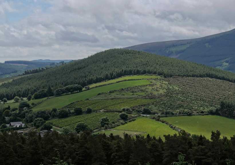
Picture: Knockree from the North West
The Wicklow Way passes over the western and southern flanks of this hill and can be used to provide access to the summit from either side. It is a pleasant walk, with good views when there is a break in the treeline.
There is limited parking W Knockree (O18095 15925) from where you head south east along the forest track following the Wicklow Way. This is a gentle ascent to A (O18826 15270) where you leave the way and make a hairpin left turn to continue following forest track up to a bench at a viewpoint B (O18367 15756) where the forest track ends. From here it is a matter of following a narrow but well defined track to the unmarked but clear summit. (Make sure to go the whole way to the end of this narrow track!) (As of July 2019, the narrow track has become badly overgrown - see note below 'The Briar Path')
An alternative start point is at Lack Wd S (O190 150) near the Glencree hostel. There is more ample parking at this point. This approach is shorter in distance, but starting from a lower height and has a steeper ascent. Again it is a matter of following the way to A (O18826 15270) where you head for the summit as described above.
Note: Unlike what is shown on the maps, the entire top of this hill is forested!
Knockree is notable for the way it stands alone in the middle of the valley, overlooked by taller hills. If it weren't forested, there would be remarkable views from the summit. As it is, there are only intermittent views on the way up.
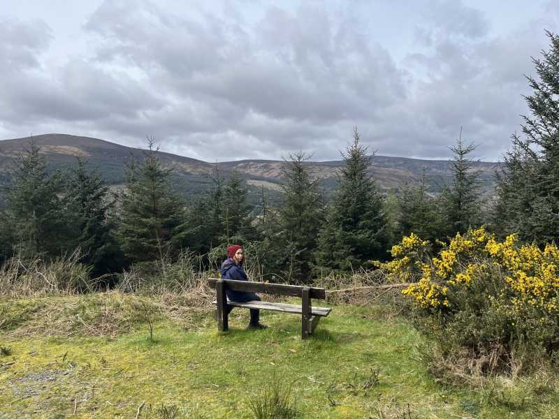
The first bench is starting to fall apart but someone has put a log under it to provide support. There are no longer any views from this point due to tree growth. The second bench C (O18369 15751) still offers views across towards Maulin, the Tonduffs and Kippure.
The last time I was here was in 2017, and at that time the path from the clearing to the summit had become very overgrown. Today, however, it was mostly clear and very manageable.
As of July 2019, the path to the summit has all but vanished under a dense covering of gorse, briars and intruding conifers. As you approach the clearing with the bench, the path can be found in the far right hand corner - you will have to pass through a low, narrow tunnel of gorse for about 6-7 metres. Things don't get much better after that. At times the path disappears completely and you will frequently encounter head-high gorse or briars. This continues almost all the way to the summit and is very unpleasant. I seriously suggest that you do not wear short sleeves and bring a machete! Linkback: mountainviews.ie/summit/1100/comment/20582/
Read Less
Read More
Picture: Great Location
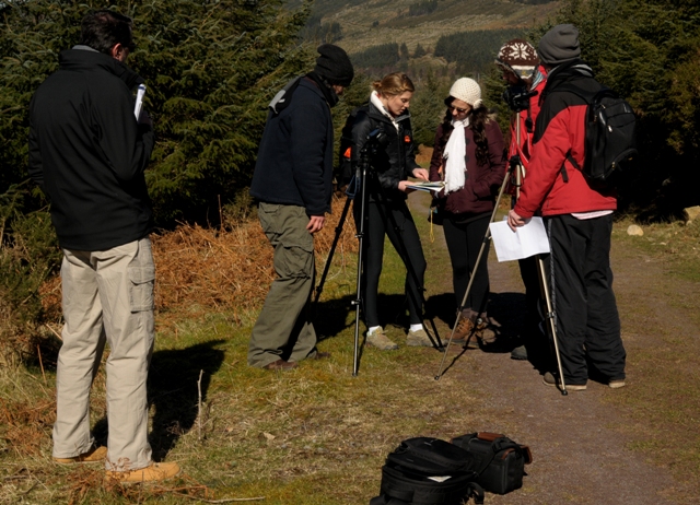
Model way to Navigation
by eamonoc
21 Mar 2014
Climbed this morning in fantastic weather, once again followed directions from previous comments started at D (O018 095) 15925. A lovely 15min walk along good forest tracks brought me to the bench overlooking Glencree and then 5mins along a narrow muddy track through some heather and gorse brought me to the top, this path is well defined. Nice views from summit. Headed back down hill saw a song thrush and thought to myself, that`s all I am going to meet today. A bit closer to the starting point there were a group of people on the path. They were either making a commercial or some form of navigation instructional short film. The very glam looking lady in all black with the ruck sac was issuing instructions about compass bearings and lining up maps, she would have come in handy last Friday on Keelogeyboy Mt as the weather in Sligo was a bit challenging! Linkback: mountainviews.ie/summit/1100/comment/15936/
Read Less
Read More
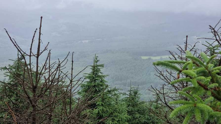
Picture: Soft day from the summit
Soft day
by Wallymee
12 Jul 2021
Visited this on a "soft day" one Sunday afternoon.
I started at point A and there was lots of space to park there.
The walk was very uneventful though the mist was around me.
The final part from the bench to the summit was easy enough.
It is overgrown and the track though barely visible once on it it is well defined.
Most of the way up (and it's not too far) I was bent over getting soaked from the trees and gorse.
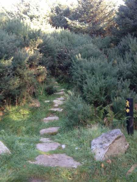
Made this walk from the Knockree youth hostel, head about 200m along the road from the hostel to find the entrance to he forest path at point D (pictured). Just keep following the path until you reach the clearing at point C, walk around the bench and follow the track up to the summit. This part of the track is narrow and has a number of thistles, so wouldn't advise taking this path wearing shorts. Linkback: mountainviews.ie/summit/1100/comment/17722/
Use of MountainViews is governed by conditions and a privacy policy.
Read general information about the site. Opinions in material here are not necessarily endorsed by MountainViews.
Hillwalking is a risk sport. Information in comments, walks, shared GPS tracks or about starting places may
not be accurate for example as regards safety or access permission. You are responsible for your safety and your permission to walk.
See the credits and list definitions.


 Our Facebook page.