Welcome to MountainViews
If you want to use the website often please enrol (quick and free) at top right.
If you want to use the website often please enrol (quick and free) at top right.
Overview

For more map options click on any overview map area or any detail map feature.
Detail Map Features
Find Suggested Walks
Find hill, mountain, island, coastal feature.
Videos
Recent Contributions
 Get Notifications
Get Notifications
Carricktriss Gorse: Safe access to this hill no longer seems possible
 TommyMc
Binnion: Tullagh Bay and Rockstown Harbour
 Jim_Brady
Donations Drive, now finished.
Good, relatively easy double bag
 Colin Murphy
Crocknapeast: Long walk up windfarm roads.
 Collaborative entry
Mulnanaff: Longish walk up windfarm road.
 Collaborative entry
Lake District: Dale Head Horseshoe
Double bag mostly on windfarm tracks.
 Colin Murphy
Binbane NE Top: Simple bag from its neighbouring top.
 Collaborative entry
Lake District: Coledale Horseshoe
Binbane: Steepish approach to relatively easy Carn.
 Collaborative entry
Crucknaree: Magnificent views!
 paddyhillsbagger
Conditions and Info
Use of MountainViews is governed by conditions and a privacy policy.
Read general information about the site.
Opinions in material here are not necessarily endorsed by MountainViews.
Hillwalking is a risk sport. Information in comments, walks, shared GPS tracks or about starting places may not be accurate for example as regards safety or access permission. You are responsible for your safety and your permission to walk.
See the credits and list definitions.
 Visit our Facebook page.
Video display
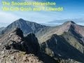
Snowdonia
Area Snowdon Subarea
Place count in area: 121,
Highest place: Snowdon - Yr Wyddfa, 1085m
Maximum height for area: 1085 metres,
Maximum prominence for area: 1039 metres,
Places in area Snowdonia:
Moel Rhiwen 401mMoel y Ci 410mParc Drysgol 404m
Moel Hebog:Bryn Banog 520mCastell 445mCraig Cwm Silyn 734mCraig-y-garn 363mFfridd Bach [Moel-ddu West Top] 534mGarnedd-goch 700mMoel Hebog 783mMoel Lefn 638mMoel Tryfan 429mMoel yr Ogof 655mMoel-ddu 553mMynydd Drws-y-coed 695mMynydd Graig Goch 609.8mMynydd Mawr 698mMynydd Tal-y-mignedd 653mPen Cwm Silyn 422mTrum y Ddysgl 709mY Garn 633mY Gyrn 459m
Snowdon:Cefn-du 441mClogwyn Pen Llechen 421mCraig Fach 608.8mCraig Wen 604.9mCrib Goch 923mCrib y Ddysgl 1065mFoel Goch 605mFoel Gron 629mGallt y Wenallt 619mLlechog 720mLliwedd Bach 818mMoel Cynghorion 674mMoel Eilio 726mSnowdon - Yr Wyddfa 1085mY Lliwedd 898mY Lliwedd East Top 893mYr Aran 747.2m
The Carneddau:Bera Bach 807mBera Mawr 794mCarnedd Dafydd 1044mCarnedd Llewelyn 1064mCarnedd y Ddelw 688mCefn Cyfarwydd 503mClip y Orsedd 429mClogwyn Llech Lefn [Bwlch y Tri Marchog Top] 637mClogwyn Mannod 418mClogwyn Mannod NW Top 405mClogwyn Pryfed 405mCraig Eigiau 735mCraig Ffynnon 590mCraig Wen 548mCraiglwyn 623mCreigiau Gleision 678mCreigiau Gleision North Top 634mCrimpiau 475mDrosgl 756.9mDrum 770mFoel Grach 976mFoel Lwyd 600.1mFoel Meirch 800mFoel-fras 942mFoel-ganol 536mGarnedd Uchaf [Carnedd Gwenllian] 926mGyrn 541.3mGyrn Wigau 643mLlwytmor 849mMoel Eilio 546mMoel Faban 408.7mMoel Wnion 579.9mMynydd Deulyn 400mPen Llithrig y Wrach 799mPen y Castell 623mPen yr Helgi Du 833mPen yr Ole Wen 978mPenygadair 507mTal y Fan 610mWaen Bryn-gwenith 414mYr Elen 962mYr Orsedd 559m
The Glyders:Carnedd y Filiast 821mCarnedd y Filiast North Top [Y Fronllwyd] 720mCastell y Gwynt 972mElidir Fawr 924mFoel-goch 831mGallt yr Ogof 763mGlyder Fach 994.3mGlyder Fawr 1000.8mMoel Berfedd 482mMynydd Perfedd 813mTryfan 917.5mTryfan Far South Peak 830.8mY Foel Goch 805mY Garn 947m
The Moelwyns:Allt Fawr 698mCarnedd y Cribau 591mCerrig Cochion 550mCerrig-y-myllt 463mCerrig-y-myllt East Top 458mClogwyn Bwlch-y-maen 548mCnicht 689mCnicht North Top 688mCraig Nyth-y-Gigfran [Y Blaen Llym] 554mCraig Stwlan 568mCraigysgafn 689mFoel Ddu 590mIwerddon 583mMoel Druman 676mMoel Dyrnogydd 524mMoel Meirch 608.9mMoel Siabod 872mMoel y Dyniewyd 382mMoel-yr-hydd 648mMoelwyn Bach 710mMoelwyn Mawr 770mMoelwyn Mawr North Ridge Top 640mYr Arddu 589mYsgafell Wen 672mYsgafell Wen Far North Top 656mYsgafell Wen North Top 669m
Note: this list of places includes island features such as summits, but not islands as such.
Highest place:
Snowdon - Yr Wyddfa, 1085mPlaces in area Snowdonia:
Moel Rhiwen 401mMoel y Ci 410mParc Drysgol 404mMoel Hebog:
Bryn Banog 520mCastell 445mCraig Cwm Silyn 734mCraig-y-garn 363mFfridd Bach [Moel-ddu West Top] 534mGarnedd-goch 700mMoel Hebog 783mMoel Lefn 638mMoel Tryfan 429mMoel yr Ogof 655mMoel-ddu 553mMynydd Drws-y-coed 695mMynydd Graig Goch 609.8mMynydd Mawr 698mMynydd Tal-y-mignedd 653mPen Cwm Silyn 422mTrum y Ddysgl 709mY Garn 633mY Gyrn 459mSnowdon:
Cefn-du 441mClogwyn Pen Llechen 421mCraig Fach 608.8mCraig Wen 604.9mCrib Goch 923mCrib y Ddysgl 1065mFoel Goch 605mFoel Gron 629mGallt y Wenallt 619mLlechog 720mLliwedd Bach 818mMoel Cynghorion 674mMoel Eilio 726mSnowdon - Yr Wyddfa 1085mY Lliwedd 898mY Lliwedd East Top 893mYr Aran 747.2mThe Carneddau:
Bera Bach 807mBera Mawr 794mCarnedd Dafydd 1044mCarnedd Llewelyn 1064mCarnedd y Ddelw 688mCefn Cyfarwydd 503mClip y Orsedd 429mClogwyn Llech Lefn [Bwlch y Tri Marchog Top] 637mClogwyn Mannod 418mClogwyn Mannod NW Top 405mClogwyn Pryfed 405mCraig Eigiau 735mCraig Ffynnon 590mCraig Wen 548mCraiglwyn 623mCreigiau Gleision 678mCreigiau Gleision North Top 634mCrimpiau 475mDrosgl 756.9mDrum 770mFoel Grach 976mFoel Lwyd 600.1mFoel Meirch 800mFoel-fras 942mFoel-ganol 536mGarnedd Uchaf [Carnedd Gwenllian] 926mGyrn 541.3mGyrn Wigau 643mLlwytmor 849mMoel Eilio 546mMoel Faban 408.7mMoel Wnion 579.9mMynydd Deulyn 400mPen Llithrig y Wrach 799mPen y Castell 623mPen yr Helgi Du 833mPen yr Ole Wen 978mPenygadair 507mTal y Fan 610mWaen Bryn-gwenith 414mYr Elen 962mYr Orsedd 559mThe Glyders:
Carnedd y Filiast 821mCarnedd y Filiast North Top [Y Fronllwyd] 720mCastell y Gwynt 972mElidir Fawr 924mFoel-goch 831mGallt yr Ogof 763mGlyder Fach 994.3mGlyder Fawr 1000.8mMoel Berfedd 482mMynydd Perfedd 813mTryfan 917.5mTryfan Far South Peak 830.8mY Foel Goch 805mY Garn 947mThe Moelwyns:
Allt Fawr 698mCarnedd y Cribau 591mCerrig Cochion 550mCerrig-y-myllt 463mCerrig-y-myllt East Top 458mClogwyn Bwlch-y-maen 548mCnicht 689mCnicht North Top 688mCraig Nyth-y-Gigfran [Y Blaen Llym] 554mCraig Stwlan 568mCraigysgafn 689mFoel Ddu 590mIwerddon 583mMoel Druman 676mMoel Dyrnogydd 524mMoel Meirch 608.9mMoel Siabod 872mMoel y Dyniewyd 382mMoel-yr-hydd 648mMoelwyn Bach 710mMoelwyn Mawr 770mMoelwyn Mawr North Ridge Top 640mYr Arddu 589mYsgafell Wen 672mYsgafell Wen Far North Top 656mYsgafell Wen North Top 669mNote: this list of places includes island features such as summits, but not islands as such.


Linkback: https://mountainviews.ie/summit/B1978/
COMMENTS for Y Lliwedd 1 of 1  Follow this place's comments

|
|
|
|
||
| MountainViews.ie, a Hill-walking Website for the island of Ireland. 2400 Summiteers, 1480 Contributors, maintainer of lists: Arderins, Vandeleur-Lynams, Highest Hundred, County Highpoints etc | |||