This website uses cookies, which are small text files that the website puts on your device to facilitate operation. Cookies help us provide a better service to you. They are used to track general user traffic information and to help the website function properly.
Feature count in area: 121, by county: : 119, Caernarfonshire [Sir Gaernarfon] (CoH) G: 1, Conwy (CoU): 1,
Highest Place: Snowdon - Yr Wyddfa 1085m
Starting Places in area Snowdonia:
None for this area
Summits & other features in area Snowdonia: Moel Rhiwen 401m, Moel y Ci 410m, Parc Drysgol 404m Moel Hebog: Bryn Banog 520m, Castell 445m, Craig Cwm Silyn 734m, Craig-y-garn 363m, Ffridd Bach [Moel-ddu West Top] 534m, Garnedd-goch 700m, Moel Hebog 783m, Moel Lefn 638m, Moel Tryfan 429m, Moel yr Ogof 655m, Moel-ddu 553m, Mynydd Drws-y-coed 695m, Mynydd Graig Goch 609.8m, Mynydd Mawr 698m, Mynydd Tal-y-mignedd 653m, Pen Cwm Silyn 422m, Trum y Ddysgl 709m, Y Garn 633m, Y Gyrn 459m Snowdon: Cefn-du 441m, Clogwyn Pen Llechen 421m, Craig Fach 608.8m, Craig Wen 604.9m, Crib Goch 923m, Crib y Ddysgl 1065m, Foel Goch 605m, Foel Gron 629m, Gallt y Wenallt 619m, Llechog 720m, Lliwedd Bach 818m, Moel Cynghorion 674m, Moel Eilio 726m, Snowdon - Yr Wyddfa 1085m, Y Lliwedd 898m, Y Lliwedd East Top 893m, Yr Aran 747.2m The Carneddau: Bera Bach 807m, Bera Mawr 794m, Carnedd Dafydd 1044m, Carnedd Llewelyn 1064m, Carnedd y Ddelw 688m, Cefn Cyfarwydd 503m, Clip y Orsedd 429m, Clogwyn Llech Lefn [Bwlch y Tri Marchog Top] 637m, Clogwyn Mannod 418m, Clogwyn Mannod NW Top 405m, Clogwyn Pryfed 405m, Craig Eigiau 735m, Craig Ffynnon 590m, Craig Wen 548m, Craiglwyn 623m, Creigiau Gleision 678m, Creigiau Gleision North Top 634m, Crimpiau 475m, Drosgl 756.9m, Drum 770m, Foel Grach 976m, Foel Lwyd 600.1m, Foel Meirch 800m, Foel-fras 942m, Foel-ganol 536m, Garnedd Uchaf [Carnedd Gwenllian] 926m, Gyrn 541.3m, Gyrn Wigau 643m, Llwytmor 849m, Moel Eilio 546m, Moel Faban 408.7m, Moel Wnion 579.9m, Mynydd Deulyn 400m, Pen Llithrig y Wrach 799m, Pen y Castell 623m, Pen yr Helgi Du 833m, Pen yr Ole Wen 978m, Penygadair 507m, Tal y Fan 610m, Waen Bryn-gwenith 414m, Yr Elen 962m, Yr Orsedd 559m The Glyders: Carnedd y Filiast 821m, Carnedd y Filiast North Top [Y Fronllwyd] 720m, Castell y Gwynt 972m, Elidir Fawr 924m, Foel-goch 831m, Gallt yr Ogof 763m, Glyder Fach 994.3m, Glyder Fawr 1000.8m, Moel Berfedd 482m, Mynydd Perfedd 813m, Tryfan 917.5m, Tryfan Far South Peak 830.8m, Y Foel Goch 805m, Y Garn 947m The Moelwyns: Allt Fawr 698m, Carnedd y Cribau 591m, Cerrig Cochion 550m, Cerrig-y-myllt 463m, Cerrig-y-myllt East Top 458m, Clogwyn Bwlch-y-maen 548m, Cnicht 689m, Cnicht North Top 688m, Craig Nyth-y-Gigfran [Y Blaen Llym] 554m, Craig Stwlan 568m, Craigysgafn 689m, Foel Ddu 590m, Iwerddon 583m, Moel Druman 676m, Moel Dyrnogydd 524m, Moel Meirch 608.9m, Moel Siabod 872m, Moel y Dyniewyd 382m, Moel-yr-hydd 648m, Moelwyn Bach 710m, Moelwyn Mawr 770m, Moelwyn Mawr North Ridge Top 640m, Yr Arddu 589m, Ysgafell Wen 672m, Ysgafell Wen Far North Top 656m, Ysgafell Wen North Top 669m
Note: this list of places may include island features such as summits, but not
islands as such.
Tryfan, 917.5mMountain
Place Rating ..
, in British over 600m, British Marilyn Lists Grid Reference SH66405 59387,
OS 1:50k mapsheet 115 Place visited by: 46members, recently by: rhw, JohnRea, annem, eamonoc, a3642278, abeach, TipsyDempy, akelly810, nordicstar, whoRya, Niamhq, skyehigh, Lucky1, IainT, oakesave
I visited this place: NO (You need to be a logged-in member for this.)
Short or GPS IDs, 6 char: Tryfan, 10 char: Tryfan Linkback: https://mountainviews.ie/summit/B1977/
Gallery for Tryfan and surrounds
Summary
for Tryfan :
Scramblers Delight
Summary created by Fergalh
2020-11-15 13:27:53
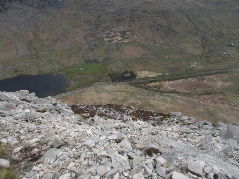
Picture: The view from the North Ridge looking down from around halfway
For anyone attempting this via the North face you need to be able to scramble and have a head for exposure and heights as there has been numerous tragedies on this mountain. Once you commit yourself to the North Face there is no going back in essence as it is a one way route. It should also be noted that as many people have climbed this, the rock has become smooth over the years and the grips can be challenging. This mountain is called 'the helicopter mountain' amongst the hill walking community in Wales because of the North Ridge. There is an alternative and steep way to the west of the North Ridge
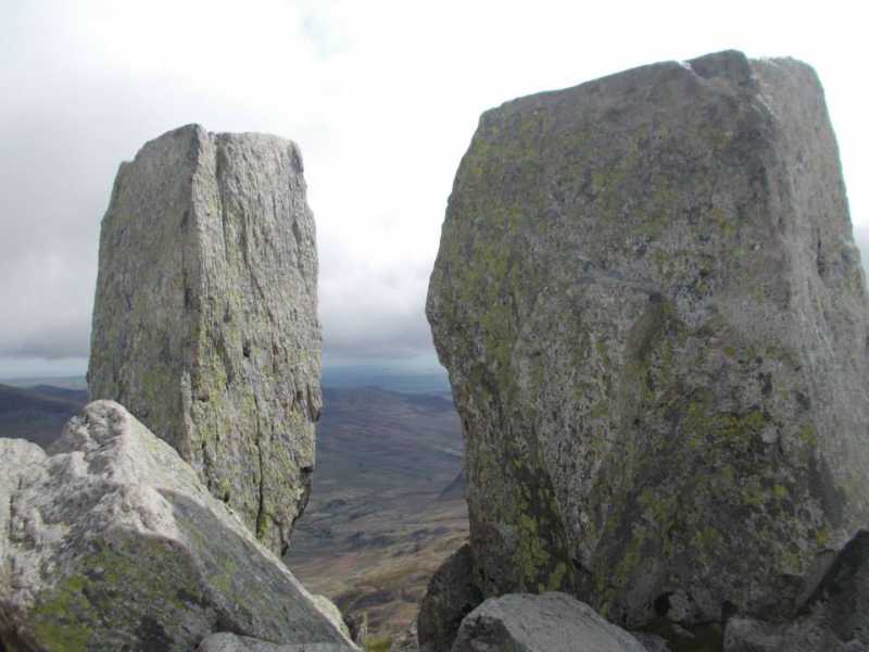
First of six peak walk. Parked below at one of the numerous car parking spaces along the road beside Llyn Ogwen. I headed up the famous North face of Tryfan to the summit. This is a wonderful scramble for anyone who has ever done it. The summit is marked by the Adam and Eve Stones whereby some people attempt to jump from one to the other (jumping that short hop is not the problem in my view, it is the stopping afterwards!). This is not recommended in my view. Linkback: mountainviews.ie/summit/B1977/comment/21370/
Use of MountainViews is governed by conditions and a privacy policy.
Read general information about the site. Opinions in material here are not necessarily endorsed by MountainViews.
Hillwalking is a risk sport. Information in comments, walks, shared GPS tracks or about starting places may
not be accurate for example as regards safety or access permission. You are responsible for your safety and your permission to walk.
See the credits and list definitions.


 Our Facebook page.