Members and Supporters, the MountainViews Committee requests your help to meet the costs of the website and of other activities such as insured events or publications.
Feature count in area: 19, all in Mayo,
OSI/LPS Maps: 22, 23, EW-WNN
Highest Place: Maumakeogh 379m
Starting Places (9) in area North Mayo: Bangor Trail Head, Carnhill, Carrowmore Wood, Erris Head, Portacloy Bay, Proesoon, Sralagagh West, Termon Hill Road, Tower Hill South
Summits & other features in area North Mayo: Cen: Pulathomas: Barnacuillew 260m E: Ballycastle Hills: Knockaghaleague 237m, Knockboha 186m, Maumakeogh 379m N: Benwee Head Cliffs: Benwee Head 255m, Barradeegin 229m, Glinsk 304m, Illanmaster 238m, Illanmaster Island 105m, Porturlin Hill 155m, Srahataggle 182m, Tawnaghmore 340m S: Bangor Erris Hills: Carrafull 269m, Knocklettercuss 370m, Knocknascollop NW Top 244m, Sheean 295m, Slieve Fyagh 335m W: Belmullet: Aghaglasheen 132m, Termon Hill 103m
Note: this list of places may include island features such as summits, but not
islands as such.
Benwee Head, 255mHill An Bhinn Bhuí A name in Irish,
Place Rating ..
(Ir. An Bhinn Bhuí [GÉ], 'the yellow cliff'), Mayo County in Connacht province, in Binnion Lists, An Bhinn Bhuí is the 1271th highest place in Ireland. An Bhinn Bhuí is the most northerly summit in the North Mayo area.
Grid Reference F81565 44279,
OS 1:50k mapsheet 22 Place visited by: 41members, recently by: markwallace, jlk, jimmytherabbit, Djouce, elizauna, learykid, Aongus, bryanjbarry, eamonoc, Aidy, Caithniadh, Lauranna, justynagru, Fergalh, Damian120
I visited this place: NO (You need to be a logged-in member for this.)
Longitude: -9.821454, Latitude: 54.333462, Easting: 81565, Northing: 344279,
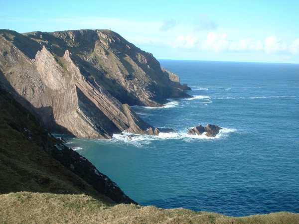
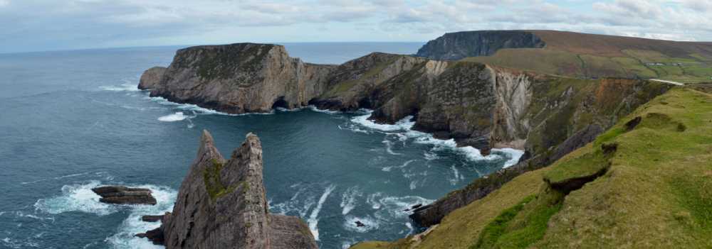
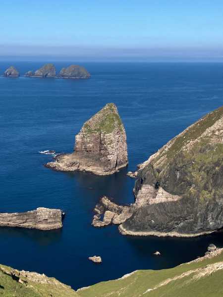
Prominence: 230m, Isolation: 4.3km ITM: 481541 844280 Bedrock type: Psammites with rare heavy mineral bands., (Benmore Formation) Notes on name: The environs of Benwee Head, with its cliffs, arches, stacks and islands, offers some of the most dramatic coastal scenery in Ireland, with which perhaps only SW Donegal and Co. Clare can compete. To appreciate them fully, you need to see them from the sea. Benwee Head is in the townland of Kilgalligan, which has been studied in detail in The Living Landscape: Kilgalligan, Erris, Co. Mayo by Seamas O Cathain & Patrick O'Flanagan.
Short or GPS IDs, 6 char: BnwHd, 10 char: Benwe Head Linkback: https://mountainviews.ie/summit/996/
Gallery for Benwee Head (An Bhinn Bhuí) and surrounds
An easy climb with Breathtaking views along the coast out to Stags of Broadhaven back across the Mullet. Accessed by taking signs for Portacloy and driving past the entrance to the beach and past old harbour. Park in new harbour and it is signposted for the track and stile up the hill. Cliffs are steep and dramatic at the edge. Also of note is the stone markings of EIRE beside the old shepherd hut. It is visible from the air and from further up the mountain. Linkback: mountainviews.ie/summit/996/comment/4669/
Read Less
Read More
Picture: View from Summit.
Benwee Head Loop.
by sandman
17 Aug 2018
As already stated Benwee Head has some of the most dramatic costal scenery in Ireland and with this in mind i decided to enjoy on a clear sunny day the joys of walking the 12.4km of the Benwee Head Loop Walk actually it is a little longer allowing for a visit to the army observation hut and the stone constructed EIRE marking.The trail head begins and ends in the village of Ceathru Thaidhg (A (F82074 41993)) and includes the harbour areas mentioned in previous comment continuing on to the summit. Fantastic views well worth the trip. Linkback: mountainviews.ie/summit/996/comment/16044/
Read Less
Read More
A spectacular landscape
by Damian120
19 Oct 2018
It's a seldom-visited area of County Mayo yet it boasts some of the most impressive coastal architecture in the entire country. After spending five years covering and exploring the landscape of the entire country, Robert Lloyd Praeger in his seminal book The Way That I Went (1937) called it the finest piece of cliff scenery in the country. It's just spectacular. Thousands of years of Atlantic erosion have created a series of sea stacks, sea arches and vertical cliff drops that have created a breathtaking landscape.
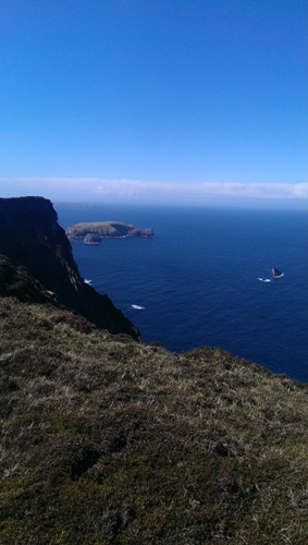
It's surprisingly well marked out, watch out for the Purple Arrows leading the way. If you wish to see the most dramatic parts you will have to veer slightly away from the main trail. There is a low-lying sheep fence running up the length of Benwee Head. The fence ends near summit area of Benwee Head overlooking Kid Island on your left. On a clear day, you can see both Sliabh Liag and Croaghaun in the far distance. The second highest and highest sea cliffs in Ireland. The trail heads back inland, but personally, I wouldn't do this. Turn right around and head back in the same direction to see this astounding scenery for the second time. Linkback: mountainviews.ie/summit/996/comment/20085/
There are fantastic views along the North Mayo coast, the Nephins, Belmullet and Achill. There is a waymarked trail (purple) from the car park beside Garvin's Shop and Post Office in Carrowteige (An Ceathrú Taidgh). This is a Gaeltacht area. We took the trail (arrows in reverse direction) as described in Paul Phelan's (2011) Connemara & Mayo Walking Guide, following the road as far as the Children of Lir Sculpture above the impressive An Priosiún cove, then headed up the slope, keeping a safe distance from the edge. There are great views as you ascend. We had good weather and great views. From the top you can look out on the Stags of Broadhaven and there are magnificent views in all directions. We descended from the top to Portacloy beach (Port an Chlóidh) for a refreshing swim. The trail continues back to Carrowteige by a side road and track. It took us 2.5 hours to walk the 9.2km from Carrowteige to Portacloy. For details see track 4722 https://mountainviews.ie/track/4722/ Linkback: mountainviews.ie/summit/996/comment/23645/
Use of MountainViews is governed by conditions and a privacy policy.
Read general information about the site. Opinions in material here are not necessarily endorsed by MountainViews.
Hillwalking is a risk sport. Information in comments, walks, shared GPS tracks or about starting places may
not be accurate for example as regards safety or access permission. You are responsible for your safety and your permission to walk.
See the credits and list definitions.


 Our Facebook page.