Cookies.
This website uses cookies, which are small text files that the website puts on your device to facilitate operation. Cookies help us provide a better service to you. They are used to track general user traffic information and to help the website function properly.
Features
Nearby features appear when you click the map.
Declutter tracks on map.
Place Search
Video
X
Pub: by
Inishowen Area , S: Iskaheen Subarea
Feature count in area: 27, by county: Donegal: 27, Derry: 1, of which 1 is in both Derry and Donegal, OSI/LPS Maps: 2, 3, 4, 6, 7
Highest Place: Slieve Snaght 614.6m

Starting Places (43) in area Inishowen:
Adderville Upper, Barnes Bend, Bunacrick, Butlers Bridge, Carnaghan Presbyterian Church, Castruse Upper, Craignacoolagh, Craignamuck, Croaghglengad West, Crockavishane South, Diarmuid and Gráinne's Bed, Doherty's Dún, Dunree Bay Carpark, EEl Hole, Effishmore Upper, Evishbreedy Bridge, Five Fingers Strand, Gap of Mamore Grotto, Gap of Mamore Road, Gap of Mamore Viewpoint, Glack, Glasmullan, Golan Bridge Track, Goorey Hill, Grania's Gap, Gransha Árd, Green Hill, Leamacrossan Hill East, Lisfannon Beach, Lough Shivnagh, Lough Turk North, Magilligan Point View, Meenabroagh, Meenyollan River, Moor House, Mullagh, Pincher's Corner, Rashenny, Roosky Upper, Rowantree Hill, St Michael's Church, Stroove Beach, Tullagh Beach

Summits & other features in area Inishowen:
Cen: Slieve Snaght: Damph 420m, Slieve Main 514m, Slieve Snaght 614.6m
N: Malin: Croaghglengad 259m, Crockalough 282m, Soldiers hill 174m
NE: North East Inishowen: Crockavishane 322m, Crocknasmug 327.5m, Grinlieve 371m
NW: Urris: Binnion 250m, Bulbin 494m, Coolcross Hill 291m, Croaghcarragh 400m, Crockmain 460m, Dunaff Hill 230m, Mamore Hill 423m, Raghtin More 502m, Slievekeeragh 389m, Urris Hills 417m
S: Iskaheen: Crockglass 397m, Eskaheen Mountain 418m, Greenan Mountain 241m, Holywell Hill 260m, Inch Top 222m, Leamacrossan Hill 392m, Mouldy Hill 312m, Scalp Mountain 484m

Note: this list of places may include island features such as summits, but not islands as such.
Rating graphic.
Holywell Hill, 260m Hill Cnoc an Tobair A name in Irish,
Place Rating ..
(Ir. Cnoc an Tobair [logainm.ie], 'hill of the well'), Derry/ Donegal County in Ulster province, in Binnion Lists, Holywell Hill is the 1262th highest place in Ireland. Holywell Hill is the most southerly summit in the Inishowen area.
Grid Reference C38500 17100, OS 1:50k mapsheet 7
Place visited by: 29 members, recently by: ChrisC, Claybird007, trostanite, wintersmick, dregish, cody1, m0jla, eamonoc, Fergalh, sperrinlad, eejaymm, Aidy, jimmyread, chalky, David-Guenot
I visited this place: NO (You need to be a logged-in member for this.)
Longitude: -7.399194, Latitude: 54.999872, Easting: 238500, Northing: 417100, Prominence: 255m,  Isolation: 3.2km, Has trig pillar
ITM: 638441 917085
Bedrock type: Schist and grit with thin marble units, (Lough Foyle Succession)
Notes on name: Situated in Altaghaderry townland. There is a holy well and megalithic cairn on this hill [The Heritage of Inishowen, Mabel R. Colhoun].
  Short or GPS IDs, 6 char: HlywHl, 10 char: HlywlHil

Linkback: https://mountainviews.ie/summit/992/
Gallery for Holywell Hill (Cnoc an Tobair) and surrounds
Summary for Holywell Hill (Cnoc an Tobair): A short but enjoyable stroll.
Summary created by Harry Goodman 2010-07-09 16:05:13
            MountainViews.ie picture about Holywell Hill (<em>Cnoc an Tobair</em>)
Picture: View NW to Greenan Mt and the Grianan of Aileach from Holywell Hill
Approach from the B193 just W of Killea at A (C372 147). Follow the minor road, signed L2013, NNE for approximately 2km to Cast Up (C37677 16800). From here a gated access road for a communications mast can be followed NE until it levels out and swings right some 100 metres from the mast. Cross a gate on the left and follow a good grassy surface around right to a fence just before and below a small but prominent raised area with a trig pillar B (C38559 16981). From here walk N across the heathery flat summit area for approximately 100 metres to the unmarked MV listed high point which is contained within the bounds of a small ring contour shown on the OS map. Return by way of ascent. An easy walk which can be completed within 30 minutes. The nearby unlisted hill of Greenan Mountain is well worth visiting to see the large and ancient Cashel C (C367 198),, the Grianan of Aileach, once the seat of the O'Neills, kings of Ulster. This is accessable by car.
Linkback: mountainviews.ie/summit/992/comment/5751/
Member Comments for Holywell Hill (Cnoc an Tobair)
Comment create / edit display placeholder

            MountainViews.ie picture about Holywell Hill (<em>Cnoc an Tobair</em>)
Picture: Trig Pillar on Holywell Hill. MV high point is raised ground on right about 100 metres from the tri
Small hill but worth a visit if in the area.
by Harry Goodman 9 Jul 2010
My initial access to this hill on 7 July 2010 was from the B193 between Derry and Newtown Cunningham. Just W of the small village of Killea at A (C372 147) I turned right on to a minor road signed L2031 and followed it up through a cross-roads for about 2km to the start of an access road for a communications mast where there was sufficient room to park off road Cast Up (C37677 16800) 
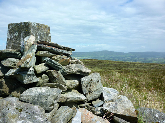
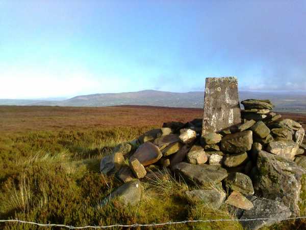
without blocking the access gate. Once over the gate, perhaps the most strenuous part of the walk, I followed the road up where it levelled out and swung right towards the mast about 100 metres away. At this point I climbed over a gate on the left and followed a firm grassy surface SE to a fence just below an obvious raised area topped by a pile of stones, built around and almost concealing the trig pillar B (C38559 16981). From here it was a short walk of about 100 metres N across the heather to the unmarked MV high point at 
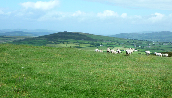
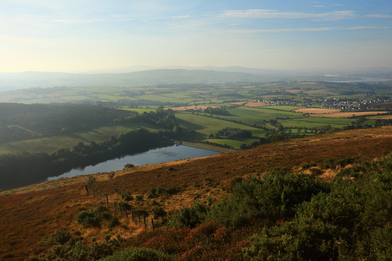
D (C385 171). Having been there, and having checked the respective heights of the MV top and that of the trig pillar, using my basic Garmin e-trex GPS, it seems to me, both visually and from the readings, that the trig pillar location is at least a metre higher if not two. However until someone better equiped that me checks it out it is quite easy to visit both "high points". I descended by way of ascent all within 25/30 minutes of easy walking. From the top I had a fine view across NW to the neighbouring hill of Greenan Mountain with the large stone Cashel of the Grianan of Aileach, prominent on it's top. This was once the seat of the O'Neills, Kings of Ulster and is well worh a visit when in the area. It is possible to drive to the top. Further to the NW across Lough Swilly were the hills of Fanad and almost due N was Scalp Mountain. To the SW was Dooish Mountain near Newtown Cunningham, another MV listed hill which could easily be included with Holywell Hill during a drive from Derry to Letterkenny by the B193. Both walks, including the off route driving would only add about an hour to the journey. Linkback: mountainviews.ie/summit/992/comment/5927/
Read Less
Read More

            MountainViews.ie picture about Holywell Hill (<em>Cnoc an Tobair</em>)
Picture: Looking north from Holywell Hill summit to Scalp Mountain
a quickie!
by slemish 6 Nov 2011
Holywell Hill sits overlooking the city of Derry, right on the border between Northern Ireland and the Republic. I wasn't expecting much from the other comments but it turned out to be a great little viewpoint, though slightly ruined by the presence of the ugly mast and dilapidated buildings. After an early start I reached the parking spot mentioned by Harry Goodman at 9 o'clock in the morning ( Cast Up (C376 168)). From there it's a leisurely stroll up the mast access road to the cairn marking the 260m summit which is situated on a little patch of grass behind the fenced-off area.

With unseasonably fine weather for November and a clear sky the views extended for miles. The Sawel-Dart ridge high in the Sperrins was easy to pick out towards the SE whilst the hills of Inishowen lay to the north, Greenan Mountain with its ring-fort and Scalp Mountain in particular are very prominent. I would agree with the other comments that the trig pillar definitely seems to be the highest point. The original surveyors usually got these things right!

I returned to the car by the same route. Anyone in the area should definitely check this one out - 20 minutes up and down is all it takes. Linkback: mountainviews.ie/summit/992/comment/6611/
Read Less
Read More

            MountainViews.ie picture about Holywell Hill (<em>Cnoc an Tobair</em>)
Picture: Note lack of partridges and pear trees...
At least it's better than Mongorry Hill...
by Peter Walker 20 Oct 2010
I have no further input with regards to the route, having vaulted the gate and walked up the road like everyone else. But I'm unconvinced that the point identified as the highest is any more adjacent to heaven than the trig point (having indulged in my usual hugely scientific determinants of relative altitude such as laying on the ground and using backgrounds to try to ascertain if a line of sight is downwards...GPSs are simply spoiling such fun).

Also, I've pictured one of the buildings on the summit which seems to be a hugely popular Christmas party venue. So if you want to find Sean, Eamon, Liam, Amanda et al on the 25th December this year, the smart money says they're up here. I've left out the side where Pauline and Noel declare their love for each other, in case they're cheating on anyone. Linkback: mountainviews.ie/summit/992/comment/6141/
Read Less
Read More

three5four0 on Holywell Hill
by three5four0 1 Nov 2009
Nowt many places to park around here, but we squeezed in by the access road at Cast Up (C376 168) managing not to block the gate into the field and the access road. From here simple follow the track up hill, thats after you have clambered over the gate, long legs help with this but watch out it is rather slippy . When you reach the Transmitter, go through a gate on your left and round the fenced off area to the top left corner of the field, where you can step over the fence courtesy of a couple of rocks. The trig point lies a sort distance away, the actual summit is a small ring contour at D (C385 171), which is only a minute or twos walk away. As we returned to the car we spotted what looked like a Golden Eagle hunting for prey on the hill. Linkback: mountainviews.ie/summit/992/comment/4237/
Read Less
Read More

            MountainViews.ie picture about Holywell Hill (<em>Cnoc an Tobair</em>)
Picture: Creevagh Hill Lake
The Charm Is In The Views
by Aidy 2 Oct 2015
The like the previous commentators, I took the track leading to the mast to access the summit, and therefore have nothing to add as regards the easy route up. Just wanted to show another aspect of the views to be had, this time down over the Creevagh Hill Lake reservoir with a glimpse of the Foyle beyond. This small hill does have a charm. Linkback: mountainviews.ie/summit/992/comment/18340/
Read Less
Read More
EDIT Point of Interest
text
Videos
(none available)
Recent Contributions
x
Conditions and Info
Use of MountainViews is governed by conditions and a privacy policy.
Read general information about the site.
Opinions in material here are not necessarily endorsed by MountainViews.
Hillwalking is a risk sport. Information in comments, walks, shared GPS tracks or about starting places may not be accurate for example as regards safety or access permission. You are responsible for your safety and your permission to walk.
See the credits and list definitions.

OSi logo
OSNI/LPS logo
Open Street Map
(Various variations used.)
British summit data courtesy:
Database of British & Irish Hills