Members and Supporters, the MountainViews Committee requests your help to meet the costs of the website and of other activities such as insured events or publications.
Feature count in area: 28, all in Mayo,
OSI/LPS Maps: 22, 23, 30, 31, CBW, EW-ACC, EW-WNN, EW-WNS
Highest Place: Slieve Carr 721m
Starting Places (24) in area Nephin Begs: Altnabrocky Adirondack Shelter, Bellanaderg Bridge, Brogan Carroll Bothy, Bunnahowna Bridge, Bunnahowna River, Burrishoole Loop, Cloondaff Church, Deel River, Furnace Lough E, Glasheens River, Glendahurk Bridge, Glennamong Bridge, LFeeagh E Treenbeg Cottage, LFeeagh E Treenbeg School Ruin, Lough Avoher Hut, Lough Feeagh, Lough Gall NW Mayo, Loughanawillan Loughs Track, Mulranny Post Office, R312 Boghadoon, R312 Prughlish, Srahduggaun, Tarsaghaunmore River, Wild Nephin Wilderness
Summits & other features in area Nephin Begs: Cen: Glennamong: Bengorm 582m, Bengorm NW Top 468m, Corranabinnia 716m, Corranabinnia SW Top 687m, Glennamong 628m, Glennamong East Top 415m, Tirkslieve 401m Cen: Nephin Beg: Aroher Hill 285m, Lettertrask 279m, Nephin Beg 627m, Nephin Beg South Top 410m E: Birreencorragh: Birreencorragh 698m, Birreencorragh South Top 564m, Birreencorragh West Top 551m, Buckoogh 588m, Bullaunmore 388m, Knockaffertagh 517m, Mount Eagle 427m, Srahmore 186m, Srahrevagh North 282m NW: Slieve Carr: Bunmore 243m, Sheeanmore 282m, Slieve Alp 329m, Slieve Carr 721m, Tawnyanruddia 531m SW: Maunthomas: Claggan Mountain NE Top 501m, Maumthomas NE Top 440m, Maumthomas SW Top 477m
Note: this list of places may include island features such as summits, but not
islands as such.
Corranabinnia, 716mMountain Coire na Binne A name in Irish,
Place Rating ..
(Ir. Coire na Binne [OSNB], 'hollow of the peak') Cushcamcarragh an extra name in English, Carraig a Binneog, Pullduff, Mayo County in Connacht province, in Arderin, Vandeleur-Lynam, Irish Best Hundred, Irish Highest Hundred Lists, Corranabinnia is the second highest mountain in the Nephin Begs area and the 101st highest in Ireland.
Grid Reference F90308 03166,
OS 1:50k mapsheet 30 Place visited by: 203members, recently by: NualaB, nupat, rhw, mdehantschutter, Magic, Carolineswalsh, MarionP, srr45, Carolyn105, ToughSoles, muddypaws, abeach, ochils_trekker, Kaszmirek78, tonio22
I visited this place: NO (You need to be a logged-in member for this.)
Longitude: -9.672137, Latitude: 53.966237, Easting: 90308, Northing: 303166,
Prominence: 541m, Isolation: 0.8km, Has trig pillar
ITM: 490284 803177 Bedrock type: Psammitic schists, quartzites, (Anaffrin Formation) Notes on name: This peak is unnamed on the OSI Discovery map, surely one of the highest peaks to lack a name. The name Corranabinnnia is found in walking guides. It is also named Cushcamcarragh (from Ir. Coiscéim Charrach, 'rocky step') in atlases. This name also appears on Bald's map of Mayo (1830), while the name Curranabinna is applied to the cirque north of the peak. Walks: for a route taking in Bengorm, Corranabinnia and Glennamong, see Whilde & Simms, New Irish Walk Guide - West and North, 72-73.
Short or GPS IDs, 6 char: Crn723, 10 char: Crnbn Linkback: https://mountainviews.ie/summit/98/
Gallery for Corranabinnia (Coire na Binne) and surrounds
Summary
for Corranabinnia (Coire na Binne):
Airy peak in SW Nephins with great views.
Summary created by markmjcampion, Onzy
2023-09-11 13:10:17
Picture: pic:gerrym
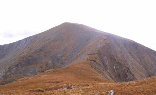
Corranabinnia, near Mulranny, is the apex and the highest pt of the Glendahurk Horseshoe. It's a highly rated peak, noted for the fine ridge which extends to that of its SW top. There are staggering views of Clew Bay, Croagh Patrick and Achill.
Corranabinnia is far from roads hence there are few practical routes and these all include other peaks.
S. The most trodden route is the circuit of Glendahurk Valley, taking in the Bengorms and the 2 Corranabinnia’s (minor scrambling on a spectacular aréte between the two) Start anti-clockwise from Gl'dHurk Brg (L91061 97962) or 300m further S where there is a stile on the right. Demanding 15k, ascent 1,000m, give about 6 hours.
NW. This potentially v boggy route starts at SraDug (F86600 07169), near some old houses. Head SE from here crossing nearly 5k of bog before rising steeply to summit C’binnia SW top via its N spur. From here it’s a fine ridge walk NE to C. To get back to the start, head for Glennamong and take its NW spur to the beckoning bog below. Take care when crossing streams near the start as many of them have silted up and are more like slowly moving bog. 6 hrs+ for circuit.
A more ambitious circuit starting further E near Srahmore and centering on the Glennamong Valley is also possible. This takes in Tirkslieve, both Glennamongs, Corranabinnia and the two Bengorms, before dropping to the road near Furness. 20k+, with some road walking - 8 hours.
Notable tracks include track/3472, track/3551 and the long, circular track/3784.
This summit ,while 5 metres lower than than the highest in the range,remote Slieve Car, is the high point of the western Nephinbeg ridge. It commands splendid views, particularly south over Clew Bay and west toward Achill (lower photo) It also forms part of a fine 20km. ridge circuit including BenGorm and Glenamong.
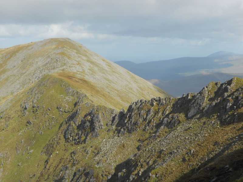
This took almost 8 hours using 2 cars, one left in a large recessed entrance at LghFee (L956 985) and finishing in the carpark at the start of the Bangor Trail. Without cars a somewhat longer variant could be done from Traenlur YH, using the ford at Gl'Mong Brg (F947 024). Top photo shows the view west from near Corranabinnia main top showing the ridge to the SW top. See my comments on the SW top Linkback: mountainviews.ie/summit/98/comment/615/
Read Less
Read More
Picture: Descending Corranabinnia
MV Walk
by wicklore
9 Oct 2017
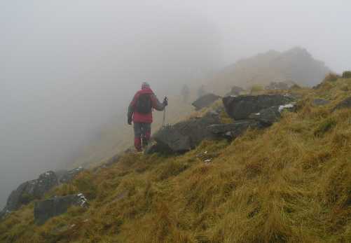
A MountainViews walk took place on Saturday 7th October. It was led by MountainViews member Liz50, and 17 hardy souls set off on this tough and demanding walk. We completed a counter-clockwise loop of the Glendahurk circuit in the Nephin Begs. Two members planned to join us as far as Ben Gorm NW Top, and the remaining 15 continued on the full circuit.
From Gl'dHurk Brg (L91061 97962) we started with a bog walk to Ben Gorm (582m). This early ascent of over 530m over tiring bog meant that (A) we got this nasty slog out of the way early, (B) we could approach the infamous Corranabinnia arête later from a more favourable NE-SW direction. Given the cloudy and sometimes wet conditions, and mix of ability amongst the group, it was a wise decision by the experienced Liz50 who has traversed the arête from both directions previously and understood the best approach for our group.
After Ben Gorm we dropped 230m to the col and ascended over 110m to Ben Gorm NW Top. Looking back at Ben Gorm from Ben Gorm NW gave another reason to be glad of the counter clockwise route – imagine facing that 230m haul up Ben Gorm towards the end of a clockwise walk?!
The 300m climb from the col below Ben Gorm NW up to the main Corranabinnia summit was demanding and included some light scrambling over some steep rocky ground. The infamous views were denied to us by cloud but the delicious home-made chocolate and oatmeal treats being passed around kept us otherwise engaged! With approx. 950m of accumulated ascent so far under our boots we knew that the majority of the climbing was done but that the section requiring most concentration lay ahead.
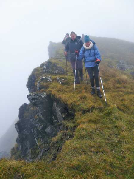
Liz50 ably navigated us down towards the arête. It suddenly appeared as the ground gave way on the right to sheer and craggy drops that disappeared into the mist below. The ground to the left (south side) fell away steeply in a tumble of rocks and steep grassy slopes. Liz50 brought us along a narrow route on the southern side several metres safely below the jagged and brooding arête. While protected from the worst of the exposure, concentration was needed as we delicately clambered over and around rocks and focussed on not slipping on the wet ground. Time momentarily took on a different speed as it was all about one slow foot and handhold in front of the other. Eventually we reached a place where a scramble up a very steep grassy slope took us suddenly onto the summit area of Corranabinnia SW. Despite the cloud we had seen enough of the arête to appreciate its challenge, and to feel a sense of achievement having completed the crossing.
Several kms of bog walk down the southern spur of Corranabinnia SW brought us back to our starting point. The cloud cleared at around 450m allowing us to once again admire the view of Clew Bay and out to Clare Island. At over 1000m of ascent, this 16.5kms, 6+ hour route over Corranabinnia is demanding, and the arête should be approached with caution. But what a great walk! Linkback: mountainviews.ie/summit/98/comment/19745/
In my opinion, the Corranabinnia horseshoe is one of the most challenging hikes in the west of Ireland, with in excess of 1000m height gain over about 14km. The ascent to Bengorm (582m) is gradual but the soft peaty underfoot conditions make it a real slog. The final climb up to the trig station at the summit of Corranabinnia is also challenging. The arete ridge between Corranbinnia main top and SW top is not as intimidating as I expected - but maybe that's because the cloud didn't allow us to see the full extent of the drops on either side! The photo shown is looking across the ridge to the SW top and believe it or not is taken in the same direction and not far to the left as milo's photo on the same mountain! Linkback: mountainviews.ie/summit/98/comment/3609/
Read Less
Read More
Picture: summit from col with Glennamong
gerrym on Corranabinnia
by gerrym
28 Aug 2005
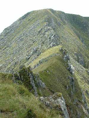
From the col with Glennamong there is a fairly narrow ridge (well it gives the feeling of as you can see from the pic) with steep drops to the double loughs of Corryloughaphuill to the NW and into the heavily forested valley of the Glennamong River to the SE. The climb is short over ground which poses no difficulty. There is a level area before the final rise to the trig point at the summit. Luckily the mist had cleared from the summit and i was afforded the breathtaking views available out over Clew Bay with its myriad of islands and over the rest of the big hills in the Nephins - Glennamong, Nephin Beg and Glencar. There was more evidence of other walkers here and would seem to suggest that the horseshoe taking in Corranabinnia Sw top, Corranabinnia and Ben Gorm would be the more popular route, not that I saw anyone on any of these hills over the 2 days spent here. There is a short drop down to the col with the SW top which looked very daunting with a sharp serrated rocky ridge to negoiate. To the SE the remainder of the walk along the ridge to Ben Gorm also looked quite a handfull, having already spent a good few hours walking and carrying tent etc. I left my pack at the summit to make the return journey to the SW top. Linkback: mountainviews.ie/summit/98/comment/1915/
Use of MountainViews is governed by conditions and a privacy policy.
Read general information about the site. Opinions in material here are not necessarily endorsed by MountainViews.
Hillwalking is a risk sport. Information in comments, walks, shared GPS tracks or about starting places may
not be accurate for example as regards safety or access permission. You are responsible for your safety and your permission to walk.
See the credits and list definitions.


 Our Facebook page.