Members and Supporters, the MountainViews Committee requests your help to meet the costs of the website and of other activities such as insured events or publications.
Feature count in area: 27, all in Antrim,
OSI/LPS Maps: 14, 15, 4, 5, 8, 9
Highest Place: Trostan 550m
Starting Places (3) in area Antrim Hills: Donalds Carn, Rathlin Island Ferry Port, Whitehead Golf Club
Summits & other features in area Antrim Hills: Cen: Central Antrim Hills: Carncormick 436m, Collin Top 429m, Crockalough 402m, Mid Hill 440m, Skerry Hill 459m, Slieveanorra 508m, Slievenahanaghan 418m, Soarns Hill 403m, Tievebulliagh 402m, Trostan 550m Central Antrim Hills: Slievenanee 543m N: North Antrim Hills: Carnanmore 379m, Croaghan 417m, Crockaneel 403m, Cross Slieve 206m, Knocklayd 514m, Lannimore Hill 207m N: Rathlin Island: Kilpatrick (Rathlin Island) 134m S: Islandmagee: Donalds Carn 141m, Muldersleigh Hill 131m S: South Antrim Hills: Agnew's Hill 474m, Big Collin 353m, Black Hill 381m, Carnearny 319m, Douglas Top 402m, Slemish 437.9m W: West Antrim: Long Mountain 215m
Note: this list of places may include island features such as summits, but not
islands as such.
Big Collin, 353mHill Collann Mór A name in Irish,
Place Rating ..
poss. Ir. Collann Mór [PDT], 'big height’, Antrim County in Ulster province, in Binnion Lists, Big Collin is the 1054th highest place in Ireland.
Grid Reference J23248 96638,
OS 1:50k mapsheet 9,14 Place visited by: 56members, recently by: Paddym99, garybuz, conormcbandon, trostanite, ElaineM76, Carolyn105, Claybird007, Dave68, eflanaga, Portosport, Kilcoobin, Rabsoffagain, Andy1287, MichaelG55, LorraineG60
I visited this place: NO (You need to be a logged-in member for this.)
Longitude: -6.084195, Latitude: 54.802432, Easting: 323248, Northing: 396638,
Prominence: 148m, Isolation: 6.4km ITM: 723172 896627 Bedrock type: Olivine basalt lava, (Lower Basalt Formation) Notes on name: Along the east coast of Ireland there is a cluster of names anglicised as Collin/Collon from Irish collann, meaning 'a height'. See also Collin Top (Co. Antrim) and Collon Hill (Co. Wicklow). They may ultimately show the same root as Lat. collis, Fr. colline and Eng. hill.
Short or GPS IDs, 6 char: BgCln, 10 char: Big Collin Linkback: https://mountainviews.ie/summit/898/
Gallery for Big Collin (Collann Mór) and surrounds
Summary
for Big Collin (Collann Mór):
Bigger than it looks
Summary created by wicklore
2010-11-14 11:56:43
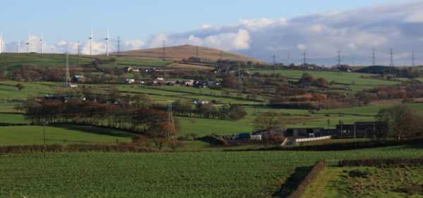
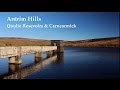
Picture: A hill best appreciated from the top
Big Collin isn’t that ‘big’ but it commands fine views of the surrounding land, including the curious bump of Slemish to the North. Because of a wind farm on Big Collin’s slopes, there are access tracks leading to near the summit. Starting at either A (J239 971) or B (J223 958), you can follow the access tracks to the highest wind turbine with only a short haul over bog to the summit. If you want to avoid the access track another option is to simply head directly onto the slopes after the access gate at 23997. The ground is quite wet and heavy going, but it is only a 20 minute ramble. The summit appears to have a cairn that is both collapsed and completely overgrown by grass and heather. Although a low hill, Big Collin is exposed and attracts paragliders to its summit area to take advantage of the breeze. (as does the wind turbine power company!) The paragliders must be confident with so many turbines spinning nearby!
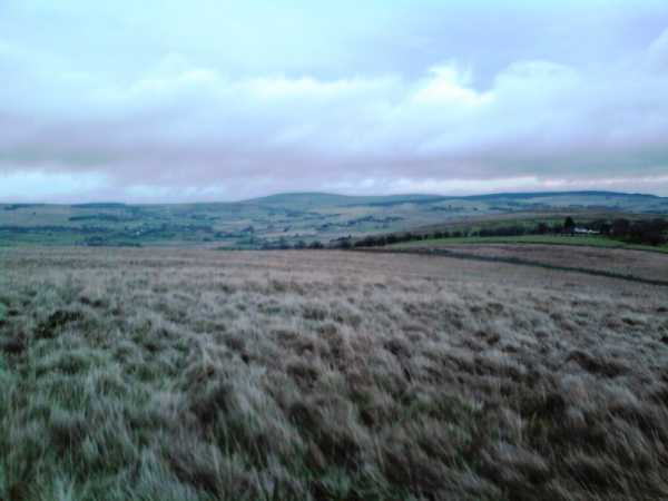
Picture: Looking east from Big Collin to Agnew's Hill
slemish on Big Collin
by slemish
26 Nov 2009
Climbed Big Collin for the third time this afternoon. The hill is now much more accessible thanks to the recent enlargement of the wind farm. I parked at the site entrance on the B94 between Ballyclare and Broughshane (A (J239 971)). From there it's a half-mile walk on the gravel track round to the western side and the wind farm itself. The turbines are really quite enormous when you get up close to them and the blades make a delightful 'swooshing' sound as they turn. Head for the turbine which is highest up the slope. From here it's an easy climb to the summit cairn at 353m. Magnificent views to Slemish and the higher Antrim hills, the Belfast hills and the Sperrins. To complete the walk I descended by the much steeper eastern slope back to the site entrance. A very easy but enjoyable trip - you can be up and down in 40 minutes. Linkback: mountainviews.ie/summit/898/comment/3691/
Read Less
Read More
Picture: Big Colin
gerrym on Big Collin
by gerrym
8 Feb 2009
Colin is one of the foothills rising from the Lough Neagh basin before the higher Antrim Hills rise to the occasion. This is no disrespect and it has a shapely form which perhaps upstages its bigger siblings in some ways.
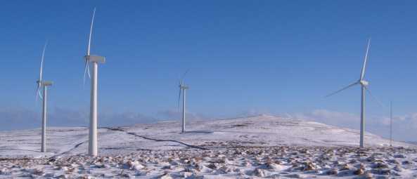
Access from the SE is from one of the entrances serving the windfarms (B (J223 958)). There is a double gate affording limited parking beside the service track - a 'Beware of the Bull' sign adorned the gate, though he was otherwise engaged today. A short walk up along the track brings Elliots Hill windfarm, run by ScottishPower Renewables, warning of the danger of entering in wet and freezing conditions or during lightning - today only had the freezing fortunately. On the track two sheep approached side by side and stopped, walked a little further and stopped again - like two gunslingers trying to unnerve me before drawing guns - then they just ran off like sheep and the moment was lost!
The track weaves around the wind turbines reaching a small cairn at Elliots Hill. The few inches of powder snow coating the ground perhaps concealing some of the changes to the terrain caused by the windfarm - though signs encourage staying on the tracks as there is an environmental management plan in place. The track drops down through a couple of gates, leaving Elliots Hill windfarm and reaching the five newer turbines at Wolf Bog on the way up to Colin. These were turning at a more liesurely pace and thier curved blades looked like giant starfish against the cold blue sky. Turn off the track for the short climb to the top of Colin. Extensive views reach to the Sperrins in the west, the higher Antrim hills to the north, and the Belfast Hills and Lough Neagh to the east and south. Return is by the same route.
A short walk of just over one hour and about 5km, made more interesting by the covering of snow i think, but still plenty to hold the attention - perhaps a good one with the kids in the summer in terms of education. Linkback: mountainviews.ie/summit/898/comment/3572/
Read Less
Read More
three5four0 on Big Collin
by three5four0
2 Oct 2008
Access to Big Collin is very straight forward, as a track has been created to serve the new wind farm on its n/e side. There is ample space to park up and not block the entrance (at A (J239 971)), there is however a picnic area a further 500 metres north east along the B94, which would be preferable when the wind farm access track is in use. It really is a short walk of no more than a k to the summit, which resembles a burial cairn, complete with a depression in its top, as if a chamber has collapsed. Nice views too! Linkback: mountainviews.ie/summit/898/comment/3348/
Read Less
Read More
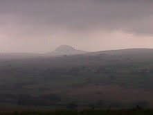
Picture: Slemish from Wolf Bog
Wolf Ghosts and Wind
by volsung
21 Nov 2011
'I'm planning to go up Big Collin tomorrow, anyone fancy coming with me?' - cue raucous laughter and ribald comments from friends. I ended up going on my own. The start is quite easy to find. Its the entrance to the Wolf Bog Wind Farm on the Collin Road (B94). You can park by the gates and follow the site track. Eventually I got bored and headed straight up towards the collapsed cairn at the top. Views of Slemish and the Belfast Hills with Tildarg dam just below. The tempation to visit the huge wind turbines proved irresistable. There are 15 of these monsters. They make a swooshing sound like blood pumping round a body. You can follow the path back from the turbines to the start or just retrace your steps back over the cairn. There must have been a sizeable wolf population around the area at one time. It's said the last wolf in Ireland was killed in nearby Glenwherry (although its not the only place to claim this dubious honour). Linkback: mountainviews.ie/summit/898/comment/6633/
Read Less
Read More
Permission required?
by StephenMullin
9 Oct 2018
Hi there
Can anybody tell me if permission is required to walk up Big Collin? If so, how does one go about obtaining this?
Many thanks! Linkback: mountainviews.ie/summit/898/comment/20083/
Use of MountainViews is governed by conditions and a privacy policy.
Read general information about the site. Opinions in material here are not necessarily endorsed by MountainViews.
Hillwalking is a risk sport. Information in comments, walks, shared GPS tracks or about starting places may
not be accurate for example as regards safety or access permission. You are responsible for your safety and your permission to walk.
See the credits and list definitions.


 Our Facebook page.