Donation Request 2024

DONATE
Members and Supporters, the MountainViews Committee requests your help to meet the costs of the website and of other activities such as insured events or publications.
You do not have to be logged in to donate.
Features
Nearby features appear when you click the map.
Declutter tracks on map.
Place Search
Video
X
Pub: by
Mangerton Area , SW: Peakeens Subarea
Feature count in area: 28, all in Kerry, OSI/LPS Maps: 78, 79, EW-KNP, EW-R
Highest Place: Mangerton 838.2m

Starting Places (30) in area Mangerton:
Cummeenboy Stream, Derrycunihy Church, Dunkerron Mid, Garries Bridge, Gowlane School Ruin, Hidden Valley Pet Farm, Inchimore West, Kenmare Bridge, Killarney Hiking Parking Lot, Knockanaskill N, Knocknsallagh Bridge, Loo River Junction, Looscaunagh Lough W, Lough Barfinnihy CP, Lough Guitane E, Lough Guitane SE, Lough Guitane W, Lynes Farm, Mangerton Walk N CP, Mangerton Walk Start, Molls Gap, Muckross Lake S, Old Rail Level Crossing, Poulacapple, River Roughty, Rossacroo na Loo Forest, Sahaleen Bridge, Shaking Rock W, Shronaboy Farm MTB, Torc Waterfall CP

Summits & other features in area Mangerton:
Cen: Dromderlough: Dromderalough 650m, Dromderalough NE Top 654m, Dromderalough NW Top 625m, Knockbrack 610m, Knockrower 554m, Shaking Rock 402m
Cen: Inchimore: Inchimore 256m
Cen: Mangerton: Glencappul Top 700m, Mangerton 838.2m, Mangerton North Top 782m, Stoompa 705m, Stoompa East Top 608m
NE: Crohane: Bennaunmore 454m, Carrigawaddra 425m, Crohane 650m, Crohane SW Top 477m
NW: Torc: Cromaglan Mountain 371m, Torc Mountain 534.8m, Torc Mountain West Top 479.4m
SE: Esknabrock: Esknabrock 406m
SW: Peakeens: Derrygarriff 492m, Derrygarriff West Top 382m, Foardal 409.8m, Knockanaguish 509m, Peakeen Mountain 554.7m, Peakeen Mountain Far NW Top 525.5m, Peakeen Mountain North-West Top 522.7m, Peakeen Mountain West Top 538.7m

Note: this list of places may include island features such as summits, but not islands as such.
Rating graphic.
Foardal, 409.8m Hill
Place Rating ..
, Fordail, Kerry County in Munster province, in Carn Lists, Foardal is the 902nd highest place in Ireland.
Grid Reference V88591 78077, OS 1:50k mapsheet 78
Place visited by: 33 members, recently by: garrettd, Grumbler, John.geary, annem, chelman7, Fergalh, eamonoc, daitho9, peter1, Wilderness, chalky, Colin Murphy, madfrankie, bandre, Wildrover
I visited this place: NO (You need to be a logged-in member for this.)
Longitude: -9.620885, Latitude: 51.944177, Easting: 88592, Northing: 78078, Prominence: 36m,  Isolation: 1.2km
ITM: 488566 578138
Bedrock type: Green sandstone & purple siltstone, (Glenflesk Chloritic Sandstone Formation)

  Short or GPS IDs, 6 char: Frdl, 10 char: Foardal

Linkback: https://mountainviews.ie/summit/777/
Gallery for Foardal and surrounds
Summary for Foardal : Simple approach from NW
Summary created by Colin Murphy 2017-12-04 14:45:41
            MountainViews.ie picture about Foardal
Picture: Looscaunagh Lough as seen from Foardal slopes
If you want to do this in isolation, the simplest route is from the car park at L LsCuna W (V882 790), and then heading SE directly up the heathery slope for 1km. The summit itself is a broad heathery mound.
Linkback: mountainviews.ie/summit/777/comment/5536/
Member Comments for Foardal
Comment create / edit display placeholder

A hidden gem of a walk in the kingdom
by Geo 6 May 2014
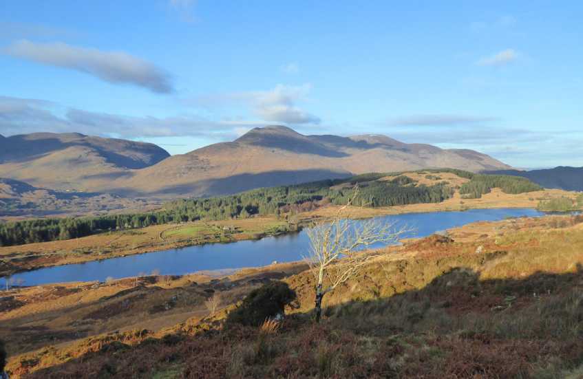
This summit is relatively easily reached with careful navigation through the lakes and roughish ground from the Kerry Way to the East.
We did it as 2nd top of a five summit, seven hour round (yes 7 hours) of Knockanaguish, Foardal, Derrygariff, Peakeen Mountain West Top and Peakeen starting at approx Gowlane School Ruin (V917 751) (T junction on Kerry Way North of Kenmare, parking limited to a couple of cars on left either side of a gateway) and going anti-clockwise a tough circuit with over 1200m of cumulative ascent and only 11km but over very demanding ground, and you will need to be able to navigate if it's misty!
We walked North on Kerry way to a gate on the right at about A (V917 755), crossed this and traversed the moorland NE to a fence which we followed to a little gate which we went through and continued to the top of Knockanaguish.
W from this summit to Kerry Way again (Steep drop off and very slippy ground, but you could use this caution all through this walk!) we followed the KW about 500m N crossing a stream then left and uphill W to Glas Loughs which we bisected at about B (V894 778), then on to Foardal summit.
The remainder of the walk was tough as the mist made us work the compass and GPS, and there were many up's and down's. The real beauty of this circuit is that there are hardly any boot prints, let alone tracks or paths(none!). Actually apart from the concrete trig on Peakeen, you could almost swear no-one had been here before, as there aren't any cairns or summit furniture descecrating these hills. Linkback: mountainviews.ie/summit/777/comment/16053/
Read Less
Read More

            MountainViews.ie picture about Foardal
Picture: Casting a long shadow...
Beyond a shadow of a doubt
by Colin Murphy 4 Dec 2017
The French writer Maupassant used to say he had lunch in the Eiffel Tower every day because it was the only place in Paris that he couldn't see the thing. A similar view might be taken of Foardal, which as a summit, is as uninspiring as they go - a broad, heathery mound that is only just discernible. On the other hand, the views from Foardal are enough to inspire any literary mind, so it's more than worth the trip. As we descended in the evening light I happened to notice our 3 shadows following the curve of the hill... Linkback: mountainviews.ie/summit/777/comment/19803/
Read Less
Read More
EDIT Point of Interest
text
Videos


Recent Contributions
x
Conditions and Info
Use of MountainViews is governed by conditions and a privacy policy.
Read general information about the site.
Opinions in material here are not necessarily endorsed by MountainViews.
Hillwalking is a risk sport. Information in comments, walks, shared GPS tracks or about starting places may not be accurate for example as regards safety or access permission. You are responsible for your safety and your permission to walk.
See the credits and list definitions.

OSi logo
OSNI/LPS logo
Open Street Map
(Various variations used.)
British summit data courtesy:
Database of British & Irish Hills