Members and Supporters, the MountainViews Committee requests your help to meet the costs of the website and of other activities such as insured events or publications.
Feature count in area: 18, by county: Dublin: 16, Wicklow: 7, Kildare: 1, of which 6 are in both Dublin and Wicklow,
OSI/LPS Maps: 43, 50, 56, AWW, EW-DM, EW-WE, EW-WW
Highest Place: Kippure 757m
Starting Places (77) in area Dublin: Allagour Road, Ballinascorney Golf Club, Ballylerane, Ballylow Bridge, Ballyreagh Wood, Ballyross Forest, Ballysmuttan Long Stone, Barnaslingan Wood, Bohernabreena North CP, Boranaraltry Bridge, Bray Harbour, Cabinteely House, Cannon's Corner, Carrickgollgan, Castelkelly Bridge, Clonkeen Road South, Cloon Wood Cp, Cransillagh Brook , Crone Wood CP, Cruagh Forest Recreation Area, Cruagh Road Hairpin, Curtlestown Wood CP, Dunnes Bank, Enniskerry, Fernhill Estate, Gap Road, Garadhu Road, Glencree Reconciliation, Hell Fire Wood CP, Johnnie Fox Pub, Kilbride Army Camp Entrance, Kilgobbin Lane, Killakee Car Park, Killiney Hill Carpark, Kilmashoge Forest CP, Kilsaran Quarry, Kippure Bridge, Kippure Estate, Kippure Transmitter Gate, Knockbrack, Knockree west, Lackan Wood S, Lamb Doyles, Laughanstown Luas, Lee's Lane, Liffey Bridge, Liffey Head Bridge, Lough Bray Lower, Lough Bray Upper, Lynch's Park Road, Marley Park CP, Novara Avenue, Bray, Old Wicklow Way entrance, Pavilion Theatre, Pine Forest Road, Putland Road, Raheenoon, Rathmichael RC Church, Rathmichael Wood CP, Sally Gap, Sally Gap N, Seahan 265', Seahan 300', Sean Walsh Park, Seefin Trailhead, Shankill Byrnes Bar, Shankill Tributary Bridge, Slademore Road, Sraghoe Brook, St Catherine's Park, The Lamb Hill, The Scalp, Tibradden Forest Recreation Area, Tibradden Lane, Ticknock Forest, Vance's Lane, Wyattville Close
Summits & other features in area Dublin: N: Howth: Ben of Howth 171m N: Naul: Knockbrack 176m S: Dublin South East: Carrickgollogan 275.2m, Glendoo Mountain 585.1m, Killiney Hill 153.5m, Knocknagun 555.3m, Montpelier Hill 383m, Prince William's Seat 553.5m, Tibradden Mountain 466.2m, Two Rock Mountain 536m S: Kippure & Kilbride: Corrig Mountain 617.1m, Kippure 757m, Seahan 647.3m, Seefin 620.6m, Seefingan 722.9m S: Saggart: Cupidstown Hill 378.6m, Knockannavea 400.8m, Saggart Hill 396.9m
Note: this list of places may include island features such as summits, but not
islands as such.
Kippure, 757mMountain Cipiúr A name in Irish,
Place Rating ..
(Ir. Cipiúr [OSI], origin obscure), Cíop Mhór, The Pole County Highpoint of Dublin and in Dublin/ Wicklow counties in Leinster province, in County Highpoint, Arderin, Vandeleur-Lynam, Irish Highest Hundred Lists, Kippure is the highest mountain in the Dublin area and the 73rd highest in Ireland. Kippure is the most southerly summit in the Dublin area. Kippure is the highest point in county Dublin.
Grid Reference O11582 15455,
OS 1:50k mapsheet 56 Place visited by: 1067members, recently by: Nomad691, jellybean, Courin, rhw, purpleknight, Sophie-Hayes, KateLeckie, GerryAlex, MeabhTiernan, Deirdreb, discovering_dann, taramatthews, Mario77, MGerry, davidrenshaw
I visited this place: NO (You need to be a logged-in member for this.)
Longitude: -6.331884, Latitude: 53.178139, Easting: 311582, Northing: 215455,
Prominence: 262m, Isolation: 3.3km, Has trig pillar
ITM: 711506 715485 Bedrock type: Pale grey fine to coarse-grained granite, (Type 2e equigranular) Notes on name: The River Liffey rises high on the slopes of Kippure. The name as shown on Discovery map is simply a transliteration of a pronunciation collected locally, but without any clear meaning. It resembles ciop, 'stump' and iúr, 'yew', but 'stump of yew' would be Ciop Iúir. Yew is unlikely to have ever grown near such a high exposed summit, but the name also refers to a townland which descends to the valley, so a connection with yew is not impossible.
Short or GPS IDs, 6 char: Kipure, 10 char: Kippure Linkback: https://mountainviews.ie/summit/73/
Gallery for Kippure (Cipiúr) and surrounds
Summary
for Kippure (Cipiúr):
Dublin's Highpoint - a boggy, heathery hill topped by a large TV transmitter.
Summary created by markmjcampion, simon3, wicklore
2023-08-31 11:47:08
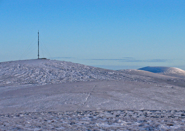
Picture: Kippure from the NW - From right on skyline Djouce, War Hill
Kippure is the highest and most southerly summit in Dublin. It is crowned by a 110 m transmitter and is approachable from all points of the compass. It can be walked on its own or as a route combining several other summits. Most routes involve heavy and heathery open bog, while one approach makes use of a gated access road. The summit is urbanised and ugly but the views on a good day are expansive in all directions, taking in Dublin, Bray, the Irish Sea and many Wicklow hills.
N. An approach through Glenasmole CstKelly Bge (O10951 19946) is the quietest and offers secret babbling brooks, mini cataracts and river cliffs, wild goats and plenty of peace. 2hrs
N. Also, along a bog track starting at Gardu Rd (O13093 19647). 2hrs
E. The adventurous can start at the cottage at L Bray Lr (O14194 16367) and head up Eagles’ Crag between the two lakes. Or park at L Bray Upr (O14270 15144) and follow a track that skirts the corrie walls. The gated access road at Kipp Gt (O14090 14193) is the most popular with the Sunday stroller. 1hr+
S. Typical approaches are from Liffey Hd (O13793 13740) or KipureBrg (O07957 14461) both of which cross heavy bog.
W. Start at Seefin Tr (O06288 16827) and take in Seefin and Seefingan en route. 2.5hrs+
NNW. Start at SHan300 (O07343 20103) and take in Seahan, Corrig and Seefingan en route. 3hrs+
Caution is needed if approaching from Seahan or Seefin to the W as these routes partly follow the boundary of the Kilbride Army Rifle Range.
Notable tracks include track/3829, track/856, the challenging track/2964, the ‘out there’ track/2966.
Hiked up Kippure on 21-5-10.Parked in the car park at the small bridge (LiffyBrg (O10949 12774)) just where the R759 road passes over a small stream.Hike length to top was 2.7Km.Took a 14 deg true bearing all the way to top.
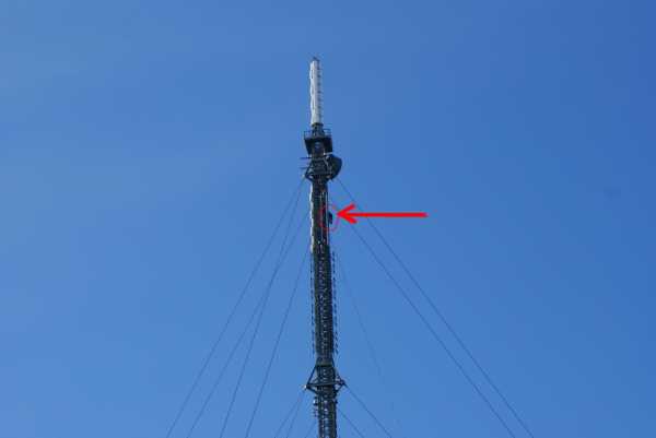
Route was quite marshy most of the way but not too bad. Met 2 deer on route which was a surprise.Didnt have time to even get the camera turned on!Reached the summit after about an hours hike.Excellent views of the 2 sugarloaf's peeping through Tonduff and War Hill to the east and Carrigvore,Gravale,Duff and mulls to the southwest.Had celebratory cup of tea on summit while watching a guy hang from the mast near the top repairing something.Retraced steps back down to car.Enjoyable couple of hours and well worth a go if you fancy something a bit more challenging than the road route. Linkback: mountainviews.ie/summit/73/comment/5824/
Read Less
Read More
Picture: Kippure across the Boggy Athdown Pass.
Homerclesse on Kippure
by Homerclesse
28 Mar 2010
I've approached the summit a few times by two alternative routes.
The first is a straight up down route following the tarmac road from the gates off the Military Road. Although a rewarding view awaits it's not the most inspiring route and a little obvious.
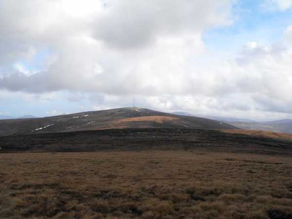
The second route is by a couple of approaches. Park at the gates of the Kippure Estate and follow the track across the road. This eventually leads into heavy forest with a lot of deeply rutted tracks and felled trees. The best option is to head to the river bank (Athdown Brook) and climb up along the left side bank of it. A nice view behind you to the Coronation Plantation and the Mullaghcleevaun Range. Once you clear the line of trees on the left then it's simply a matter of climbing up to the top of Seefingan with it's mighty Cairn. Great views of the Blessington Lakes, the other hills of the West Wicklow range, south to Mullaghcleevaun and east to Kippure, our destination. It's very hard to miss with it's huge Aerial on top. Head out across the boggy Athdown pass and follow a line up to the top of Kippure. Being the highest point in County Dublin you will be rewarded with amazing views on a clear day. All the major summits are visable. It's a very boggy approach in places but very challenging. Head back down roughly 220 degrees to the bridge on the Sally Gap and back to the car along the Road.
An alternative route is to park on the west side of Seefin at the gates and go straight up the Forest track. Follow the ridge from Seefin and then to Seefingan and on to Kippure as described above. The obvious disadvantage is you'll be heading back the same way to the car. Linkback: mountainviews.ie/summit/73/comment/4547/
Read Less
Read More
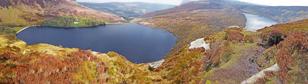
Picture: A composite image of Upper and Lower Lough Bray from Eagle's Crag.
Magnificent redeeming feature
by Colin Murphy
20 Apr 2021
Been up here a few times before (half of Dublin has) so with lockdown limiting options, I decided to approach it via a little-used route. Kippure is largely a big round lump of a mountain, topped by an ugly transmitter, but it is redeemed entirely by the presence in its eastern slope of two spectacular corrie loughs: Upper and Lower Lough Bray. I started at the car park at A (O143 153) and proceeded west then NW around the cliff edge about the upper lough, then turned west again at B (O133 154), across a relatively easy slope covered in short heather (dry the day I did it). I hooked up with the paved access road at C (O128 155) which I followed to summit. I then retraced my steps leaving the access road at the same place but now heading in a EEN direction to D (O135 160), or the point known as Eagle's Crag - a large rock outcrop. The views from here are in utter contrast to what Kippure otherwise offers - a spectacular bird's eye view of both loughs and east Wicklow beyond. A friend had actually told me it was possible to descend directly from this point down a steep, but doable track that runs down and then along the eastern side of the upper lough and back to my car, which I happily followed. If you're doing Kippure, make sure you do the Crag! Linkback: mountainviews.ie/summit/73/comment/22904/
Read Less
Read More
padodes on Kippure
by padodes
25 Jan 2009
At the risk of appearing to comment lately on nothing else but Kippure and the twin corries at its eastern end, I would like to add a little detail to the more interesting Lower Lough this time.
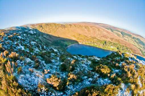
In his book ‘The Neighbourhood of Dublin’ (1920), the walking enthusiast Weston St. John Joyce spoke of the lower lake as “a wild, gloomy tarn…believed by some to be the crater of an old-world volcano”. There’s an earlier reference to this hypothesis in A. G. Wright’s ‘A Guide to the County of Wicklow’ (1827), who says that “appearances favour the conjecture”. We know today that the true origin of the lake lies in the power of ice, but looking at the photo (I used a fish-eye to capture as much as possible), one can easily see how the mistake could be made.
On the far side of the lake can be seen the south-facing Lough Bray House, “embosomed in a grove of trees”, as St. John Joyce writes. He says it was “built in the Old English style of architecture, and was originally a gift by the Duke of Northumberland when Lord Lieutenant, to his medical adviser, Sir Philip Crampton”, but other accounts I have seen link the house to Lady Powerscourt, who is said to have built a summer house (or shooting lodge) here towards the end of the 19th century. At the western end of the lake, which comprises 37 Irish acres, a beach was created by bringing up cartloads of sand all the way from Brittas Bay. I was surprised to read, recently, that the lake even has its monster in residence. On the web page www.paranormaldatabase.com/ireland/leinster, there’s an account, dated 3 June 1963, of “Two friends watching the Lough [who] spotted a large, dark grey circular body rise from the lake, almost four metres in circumference. The head was slightly away from the body, and stood 90 centimetres out of the water”. Believe it if you will. Linkback: mountainviews.ie/summit/73/comment/3547/
Read Less
Read More
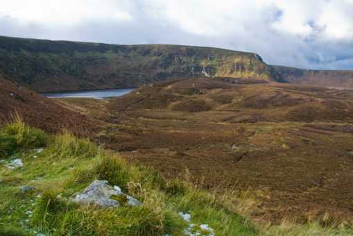
Picture: Lough Bray Upper and Eagles' Crag
padodes on Kippure
by padodes
21 Jan 2009
I would like to add a few details to Wicklore’s comment on walking around Lough Bray (Upper and Lower), which may add to the interest of exploring this area. The massive outcrop between the two corries is known as the Eagles’ Crag (although the name does not appear in the OSI map). It is recorded that eagles did, in fact, breed here into the 19th century, when they were finally hunted to extermination. It still isn’t unusual to see a peregrine falcon or kestrel rising on the thermals created by the corries, but you are just as likely to see today colourful paragliders doing the same when the weather is favourable. The corries themselves were formed during the last Ice Age and marked the head of a glacier that flowed down the length of Glencree Valley, with, I would surmise, minor tributaries coming from Raven’s Rock glen (east of Lugduff) and the little glen at Powerscourt Waterfall, each of which has its own modest cirque. The lakes that formed behind the moraines are quite deep and do not seem to communicate above ground, which has led to speculation that they may nonetheless be connected underground, with a flow from the Upper to the Lower. The water is acidic and low in nutrients, so aquatic life is rather poor and you will see that waterfowl are infrequent visitors. I read once that whooper swans have been known to descend here in winter, but I have never myself seen their white beauty on these black waters, despite many a visit. There is abundant plant life around the corries, I am assured, but the names that leave some botanising friends of mine ecstatic, like woodrush, cowberry and quillwort, are rather lost on me.
Parking close to the roadside cottage by Lough Bray Lower is very restricted, but this does not prevent, at weekends, a lot of cars from parking there anyway, and on both sides of the narrow road at that. It can be hard to get by, if you are travelling through. Add to that the madness of tour operators who have begun to send big coaches over the Military Road in recent years, and you have all the ingredients of a bottleneck worthy of the Red Cow Roundabout. Linkback: mountainviews.ie/summit/73/comment/3536/
Use of MountainViews is governed by conditions and a privacy policy.
Read general information about the site. Opinions in material here are not necessarily endorsed by MountainViews.
Hillwalking is a risk sport. Information in comments, walks, shared GPS tracks or about starting places may
not be accurate for example as regards safety or access permission. You are responsible for your safety and your permission to walk.
See the credits and list definitions.


 Our Facebook page.