This website uses cookies, which are small text files that the website puts on your device to facilitate operation. Cookies help us provide a better service to you. They are used to track general user traffic information and to help the website function properly.
Feature count in area: 27, by county: Mayo: 15, Galway: 15, of which 3 are in both Galway and Mayo,
OSI/LPS Maps: 37, 38, CBE, EW-CON, MSW
Highest Place: Maumtrasna 682m
Starting Places (53) in area Partry & Joyce: Aasleagh Waterfall CP, An Móinín Mór, Ballydoo Lough, Barrevagh Bridge, Bealanabrack River Tributary, Black Rock, Bohaun, Bracklagh, Buckaun, Bunduvowen, Cammanagh, Carraig Bar, Carrowrevagh Lough, Clonbur, Cummer, Derrassa, Derrinkee Wood, Doon Rock, Failmore River, Finny Church, Fooey River Road, Glendavock, Glenmask, Glennacally Bridge, Glensaulmore Trailhead, Glentraigue, Gowlaunlee Lake, Keelkill North, Killeennimat Burial Ground, Knockaunnabausty (Cnocán na bPáistí), Knocknafaughy SW, Lecarrow, Leenane, Leenane Hotel, unuseableLeenane R336, Lough Nambrackkeagh, Maum Bridge Road Lower, Maum Bridge Road Mid, Maum Bridge Road Upper, Mount Gable CP, Otter Pool, Owenbrin Bridge, Owenbrin Tributary, Owenduff River, Red Island, RIC Barracks Ruin, Rinavore East, Rinavore SW, Shanafaraghhaun Cross, Sheeffry Pass, Tawnyard Lough, Teevinish West, The Larches Pub
Summits & other features in area Partry & Joyce: Cen: Finny: Glenbeg East 372m Cen: Knocknafaughy: Knocknafaughy 254m, Rinavore 426m Cen: Maumtrasna: Barnahowna 516m, Buckaun East 495m, Glennagleragh Mtn 617m, Knocklaur 518m, Maumtrasna 682m, Maumtrasna North-East Top 572m, Tullymorehill 279m N: Ballintober Hills: Bohaun 393m, Corveagh 233m, Croaghrimkarra 271m, Keelkil 239m SE: Cornamona: Mount Gable 417.8m, Bohaun 424m, Knocknagussy 456m SW: Bunnacunneen: Ben Beg 560m, Bunnacunneen 575m, Bunnacunneen South Top 539m, Bunnacunneen SE Top 479m, Lugnabrick SW Top 494m, Lugnabrick NE Top 494m W: Devilsmother: Devilsmother 645m, Devilsmother South Top 509m, Devilsmother North Top 595m, Devilsmother Far North Top 601m
Note: this list of places may include island features such as summits, but not
islands as such.
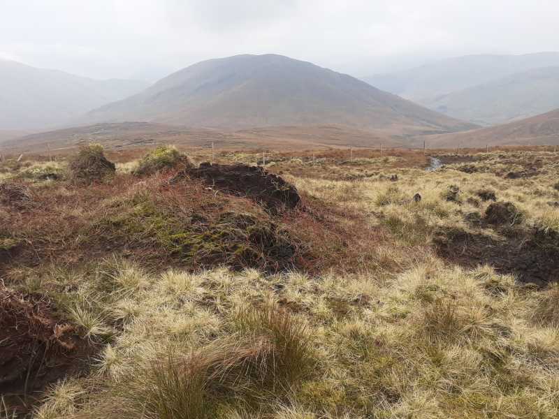
Rinavore, 426mHill Roighne Mhór A name in Irish,
Place Rating ..
(Ir. Roighne Mhór [TR], 'big excellent portion'), Reena, Galway County in Connacht province, in Carn Lists, Roighne Mhór is the 825th highest place in Ireland.
Grid Reference L91611 58503,
OS 1:50k mapsheet 37 Place visited by: 17members, recently by: annem, bryanmccabe, OisinD, markmjcampion, Cobhclimber, Fergalh, eamonoc, tphase, sandman, juliewoods, eeimly, markwallace, chalky, maxim, taobear
I visited this place: NO (You need to be a logged-in member for this.)
Longitude: -9.636645, Latitude: 53.565403, Easting: 91611, Northing: 258503,
Prominence: 242m, Isolation: 2.4km ITM: 491584 758523 Bedrock type: Conglomerate, sandstone, mudrock, tuff, (Rosroe Formation) Notes on name: Tim Robinson suggests roighne is righin, 'tough or stubborn', (TR, 103) but it seems more likely that it is simply roighne, 'the best part', perhaps a praise-name for an old land division rather than the hill itself.
Short or GPS IDs, 6 char: Rnvr, 10 char: Rinavore Linkback: https://mountainviews.ie/summit/711/
Apparently unpopular outlier between Partry and Maamturk Mountains.
by markwallace
28 Dec 2014
Judging by MV figures, Rinavore might well be the least climbed 400+ metre hill in the Connemara/ South-west Mayo region. I climbed it on a hot afternoon this summer. Parked at a layby with space for only one car roughly at Rn'Vr SW (L910 577) - slightly south-east of the settlement at Lee na Li (per Harvey map). No gate around so climbed the fence and headed up the hillside, which rises straight from the road. I climbed by the side of a stone wall that goes almost all the way up to the top, though broken in many places.
Rinavore is really steep, grassy slopes all the way up from near sea-level to 426m – note the contours on OS 37 – very close together! Needs care on the descent for the same reason.
Memory may be out, but I don’t remember there being a cairn at the broad, flattish top. Good views to Mweelrea, Ben Gorm, Bunnacunneen, Devilsmother, and the Maamturks. Linkback: mountainviews.ie/summit/711/comment/17774/
Read Less
Read More
Picture: Rinavore from the northh
part of a quiet and chilled out low level circuit
by markmjcampion
12 Nov 2020
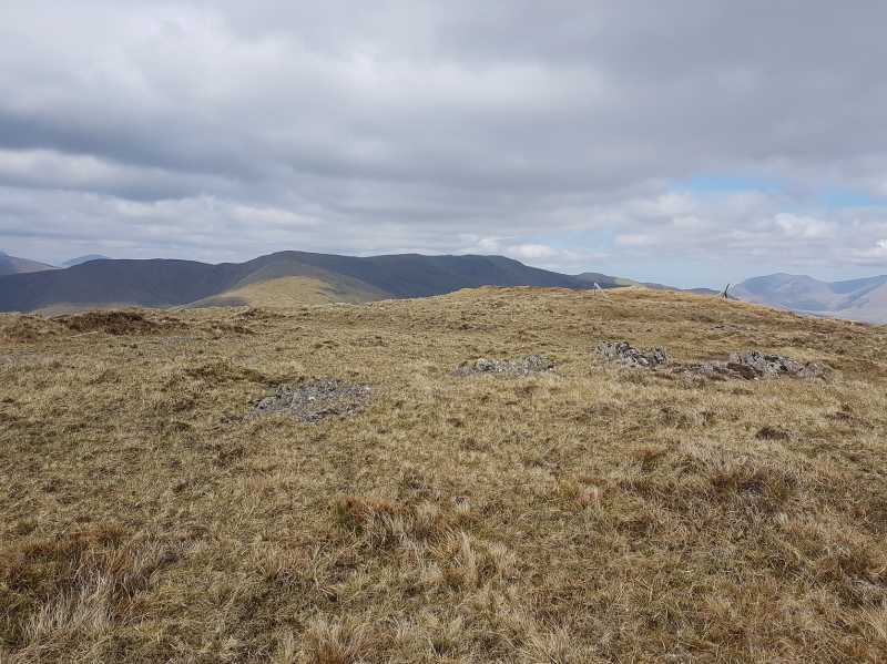
I parked at the same place as Sandman and headed west up the farm track for 200 m and, after crossing a minor bridge, I struck out left for the obvious line of rocky outcrops. From there I headed up a steepish but comfortable incline and was at the summit point in no time at all. It was nice to see all the other lower hills I had done recently stacked up one behind the other...Taobh Dubh, Culóg and Binn Idir an Dá Log. From there I headed north down the ridge and, a little while before the base, i cut across country to the gash below Rinabeg. I crossed the stream easily and headed on up the steep short slope of Rinabeg. Definitely worth doing as the views west from here were very nice. I then headed to A (L90762 61071) and was tempted to head up the DM south top but got lazy and headed southeast towards Knocknafaughy instead. This was easy going with reasonably firm bog underfoot. From Knocknafaughy I then headed steeply downhill in a due south direction, skipped across the stream and walked the single km back to my car as the unforecast rain poured down. What else can you expect out west! The circuit was approx. 12 k, a little shy of 700m in ascent and it took me about 3hrs 45 mins. Linkback: mountainviews.ie/summit/711/comment/21321/
Read Less
Read More
Picture: Summit Area.
Nice Views.
by sandman
26 Sep 2022
Because of my visit to nearby Knocknafaughy I ascended this hill on the opposite side to Mark which, although steep, is not as steep as the ascent from the R336 road. If you wish you can park at Rn'Vr E (L92886 58759) and follow the farm track to the base of the hill. No cairn exists at the summit so, to the previous comment, your memory is still good. Linkback: mountainviews.ie/summit/711/comment/18913/
Use of MountainViews is governed by conditions and a privacy policy.
Read general information about the site. Opinions in material here are not necessarily endorsed by MountainViews.
Hillwalking is a risk sport. Information in comments, walks, shared GPS tracks or about starting places may
not be accurate for example as regards safety or access permission. You are responsible for your safety and your permission to walk.
See the credits and list definitions.


 Our Facebook page.