Members and Supporters, the MountainViews Committee requests your help to meet the costs of the website and of other activities such as insured events or publications.
Feature count in area: 44, by county: Tipperary: 36, Limerick: 8,
OSI/LPS Maps: 52, 53, 54, 58, 59, 60, 65, 66
Highest Place: Keeper Hill 691.6m
Starting Places (31) in area Midlands SW: Ballincurra Hill South, Ballyhourigan Wood Loop Walk, Barnane Lodge, Castlewaller Wood Forest Road, Coillte Knockanroe, Commanealine Wood, Commaun Beg North, Cullaun South, Cummer South, Curreeny Wood, Doonane Forest Carpark, Foildhine Mulkeir Rivers, Glenaneagh Park, Glenstal Wood CP, Gortagarry Hill West, Greenan Cross, Knockadigeen Hill SW, Knockanora East, Knockanully, Knockaviltoge East, Knockfune Wood Bend, Knockmaroe Wood, Knockmehill South, Knockteige SW, Nicker, Raven's Rock, Ring Hill West, River Doonane, The Lookout, Tobernagreana, Upperchurch
Summits & other features in area Midlands SW: Cen: Mauherslieve: Cummer 405m, Foilduff 400m, Knockmaroe 411m, Mauherslieve 543m E: Upperchurch Hills: Knockalough 427m, Knockaviltoge 364m N: Knockshigowna: Knockshigowna 212m NE: Devilsbit: Benduff 455m, Black Hill 228m, Devilsbit Mountain 480m, Gortagarry 458m, Kilduff Mountain 445m, Knockanora 433m NE: Templederry: Ballincurra Hill 403m, Commaun Beg 403m, Cooneen Hill 467m, Coumsallahaun 320m, Knockadigeen Hill 402m NW: Arra Mountains: Corbally Hill 339m, Tountinna 457m NW: Silvermine Mountains: Silvermine Mountains East Top 479m, Silvermine Mountains Far East Top 410m, Silvermine Mountains West Top 489m SE: Hollyford Hills: Falleennafinoga 388m, Foildarg 440m, Glenaneagh 420m, Gortnageragh 418m, Knockastanna 444m, Knockbane 433m, Lackenacreena 413m, Ring Hill 426m, Tooreen 457m SW: Slieve Felim: Cullaun 460m, Derk Hill 236m, Knockroe 204m, Knockseefin 235m, Slieve Felim 427m, Slieve Felim East Top 423m, Slieve Felim South Top 407m W: Keeper Hill: Bleanbeg 368m, Boolatin Top 446.6m, Keeper Hill 691.6m, Knockane 411m, Knockfune 452m
Note: this list of places may include island features such as summits, but not
islands as such.
Tountinna, 457mHill Tonn Toinne A name in Irish,
Place Rating ..
(Ir. Tonn Toinne [OSI], 'wave of the wave'), Tipperary County in Munster province, in Carn Lists, Tountinna is the 710th highest place in Ireland. Tountinna is the second most westerly summit in the Midlands SW area.
Grid Reference R73736 77344,
OS 1:50k mapsheet 59 Place visited by: 111members, recently by: BarnabyNutt, Tuigamala, learykid, Moirabourke, Lauranna, wallr, westside, Jai-mckinney, nammona, Oscar-mckinney, Carolyn105, Arcticaurora, Krzysztof_K, johncusack, Colin Murphy
I visited this place: NO (You need to be a logged-in member for this.)
Longitude: -8.390552, Latitude: 52.84676, Easting: 173736, Northing: 177344,
Prominence: 402m, Isolation: 2.6km ITM: 573691 677385 Bedrock type: Fine & some coarser greywacke, (Slieve Bernagh Formation & conglom & coarse greywacke) Notes on name: This tautological name is explained by the fact that it has been corrupted from its original form, Tul Toinne, 'hillock of the wave'. The wave in question was the biblical flood, which, according to Lebor Gabála Érenn (commonly known as the Book of Invasions), drowned most of the members of the first invasion of Ireland, led by Cesair. Fionntán was the only member of the party who took refuge in this mountain. While the others were drowned in the deluge, he survived to tell the tale to later generations. Near the summit is a tomb known as the Graves of the Leinstermen. A legend associates this with a bloody dispute between some of Brian Boru's men and some visiting nobles from Leinster, but the tomb is actually prehistoric. A lower hillock to the N is called Knockaunreelyon (Cnocán Rí Laighean, 'hillock of the king of Leinster').
Short or GPS IDs, 6 char: Tntn, 10 char: Tountinna Linkback: https://mountainviews.ie/summit/596/
Gallery for Tountinna (Tonn Toinne) and surrounds
Summary
for Tountinna (Tonn Toinne):
Masts don't always spoil a view.
Summary created by jackill
2012-06-17 21:09:52
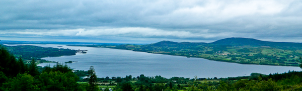
Picture: Tountinna on the right as seen from Moylussa
It is possible to drive to the summit area using the access road beginning at A (R73439 76446).
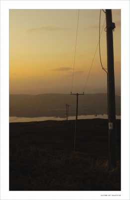
This road is steep at the start so not one for a frosty day.The top is marked by a wide parking area with some seating next to a fenced off communications tower.
Extensive views of the whole Shannon region and Lough Derg.
Access is also possible by parking at B (R73560 78032) and following the Lough Derg way uphill.
Biggest problem I had with getting to the top of Tountinna was finding the road to take me up! While driving around, I came upon the Grave of the Leinstermen and the hill beside it on which stands Millenium Cross. If you are looking for a bit of a stroll, there is a carpark and a 1200metre walk over an established path to the cross. Met a couple of people out walking but it wasn't my cup of tea - is it just me or does anyone else find a large cross on a hill slightly un-nerving? It didn't help that one of the stay cables was snapped and the wind was whistling by the top of the cross, that and the old stone cross had been reduced to rubble by a lightning strike. Good views from the cross and probably not a bad spot for a stroll if you are bringing the kids.
Back into the car and eventually found the road up to Toutinna. First 100 yards or so are very steep but it's solid tarmac all the way up as it is obviously a service road for the communications towers that it houses. Ample parking space on top at the base of the largest set of towers. Unfortunately by the time I'd got up, it was starting to get dark (only got the one photograph) but there are some glorious views of Lough Derg to be had up there - I can only imagine the views on a clear, sunny day. Take time going back down the service road as there is a fantastic view back in the Ballina/Killaloe direction.
Now for the directions - I came from Ballina and the directions I got were as follows: imagine you are coming across the bridge from Killaloe - take a left at the mini-roundabout and then the next right up by the school. You then need to take the correct right turns to get up on top of the hill. This is where it all went hopelessley wrong for me so my directions are as follows:
From Portroe, follow the signs for Millenium Cross or Graves of the Leinstermen. Around 400-500 yards after the car-park for the cross (which should be on your right), the road swings to the right and there is road to the left (very sharp, nearly coming back on itself) down a hill. Go down this road and shortly after it swings right and starts to climb uphill, there is a road to the left. This is the service road. It's extremely steep in places, particularly the first 100 yards and I wouldn't recommend attempting it in icy conditions.. Linkback: mountainviews.ie/summit/596/comment/3351/
Read Less
Read More
Picture: Loughderg from Tountinna
YoungJohn on Tountinna
by YoungJohn
30 Mar 2010
What views. The twelve pins way to the west and the wicklow mountains snowcapped to the east. This view rivals Ard Erins in the Slievebloom for expanse of countryside but Tountinna has Loughderg, shining blue on this clear day, 8th March 2010. I had to use the binoculars to be sure it was the Twelvepins and the Wicklow Mountains. Southwards The Galtees, Ballyhoura's, eastwards Keeper, the Devils Bit range from Knockanora to Benduff, way to the southeast the Knockmealdowns...and way to the south west barely visible the fabled Kerry Mountains....(I vow to return to get photo's). West wards the Slieve Bearna, Aughty's and the hills of Clare overlooking Galway bay (the bay may or may not be visble there was a slight ground mist). The great surprise was the Twelvepins and the Maumturks way way to the west. Northwards the Slieveblooms. Northeast along the Shannon - Shannonbridge Power Station to its left the seven sister woods of Eyrecourt. How to get there. I went into Ballina from the Birdhill direction. Go straight then take the first left along the loughderg drive. This road downgrades into a narrow country road but eventually it climbs to a viewing point, called the gravesof the Leinster men viewing point, near a telecoms mast. Opposite this mast there is a woodenpost with a hillwalker sign on it. The path appears to be recently dug. This route takes you all the way to the summit and those awe inspiring views. One point of interest more the trig is contained in a large plastic pipe but its not at the summit. The aerials are. Of course there is the service road... climbed today 28/3/10 with BigEoin, photo of Loughderg to prove it. NB The name of the hill on which stands the Millenium Cross and the ruins of the cross erected to celebrate the Eucharistic Conference in 1932 is Laghtea, it is 1,088 ft over sea level. I note that it is not listed on Mountainviews. While it is only a small height up from the road it is probably 500 ft over the lake at least, it is a maybe.....perhaps due to its great views it should be considered for inclusion! Linkback: mountainviews.ie/summit/596/comment/4487/
Read Less
Read More
gerloughnanne on Tountinna
by gerloughnanne
31 Aug 2008
Tountinna offers fantastic views all over the Shannon and Lough Derg region. Access is painfully easily as there is a well tarmaced road that leads up from Balina.This road is very steep and a great challege for cyclists. There is space to park on top as there's a transmitter on the summit. For the purest however you can take a route from the Graves of the Leinstermen site which is the other side of the mountain Linkback: mountainviews.ie/summit/596/comment/3276/
Read Less
Read More
Small Diversion
by three5four0
18 Sep 2011
The summit lies just off a track before the car park and mast area. There are several small rises in the heather, the seemingly highest one is marked with a small cement pole, with a letter marked onto it. G I think. The summit spot height is of course in the slight hollow between the rises.
Climbed (?) this on the way home from Kenmare, I think from when I left the motorway at Bird Hill, till I arrived back on the motorway was less than an hour. Linkback: mountainviews.ie/summit/596/comment/6515/
Read Less
Read More
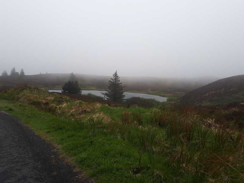
Picture: Black Lough
To drive or not to drive?
by TommyV
5 Nov 2018
As mentioned by jackill, it is possible to drive all the way to the summit of Toutinna which is what we did given the summit was covered in cloud. I would imagine the other option mentioned by jackill from the North side of the hill going up by the Graves of the Leinster Men would be a little bit more satisfying than driving all the way to the summit. Linkback: mountainviews.ie/summit/596/comment/20196/
Use of MountainViews is governed by conditions and a privacy policy.
Read general information about the site. Opinions in material here are not necessarily endorsed by MountainViews.
Hillwalking is a risk sport. Information in comments, walks, shared GPS tracks or about starting places may
not be accurate for example as regards safety or access permission. You are responsible for your safety and your permission to walk.
See the credits and list definitions.


 Our Facebook page.