Cookies.
This website uses cookies, which are small text files that the website puts on your device to facilitate operation. Cookies help us provide a better service to you. They are used to track general user traffic information and to help the website function properly.
Features
Nearby features appear when you click the map.
Declutter tracks on map.
Place Search
Video
X
Pub: by
Nephin Begs Area , SW: Maunthomas Subarea
Feature count in area: 28, all in Mayo, OSI/LPS Maps: 22, 23, 30, 31, CBW, EW-ACC, EW-WNN, EW-WNS
Highest Place: Slieve Carr 721m

Starting Places (24) in area Nephin Begs:
Altnabrocky Adirondack Shelter, Bellanaderg Bridge, Brogan Carroll Bothy, Bunnahowna Bridge, Bunnahowna River, Burrishoole Loop, Cloondaff Church, Deel River, Furnace Lough E, Glasheens River, Glendahurk Bridge, Glennamong Bridge, LFeeagh E Treenbeg Cottage, LFeeagh E Treenbeg School Ruin, Lough Avoher Hut, Lough Feeagh, Lough Gall NW Mayo, Loughanawillan Loughs Track, Mulranny Post Office, R312 Boghadoon, R312 Prughlish, Srahduggaun, Tarsaghaunmore River, Wild Nephin Wilderness

Summits & other features in area Nephin Begs:
Cen: Glennamong: Bengorm 582m, Bengorm NW Top 468m, Corranabinnia 716m, Corranabinnia SW Top 687m, Glennamong 628m, Glennamong East Top 415m, Tirkslieve 401m
Cen: Nephin Beg: Aroher Hill 285m, Lettertrask 279m, Nephin Beg 627m, Nephin Beg South Top 410m
E: Birreencorragh: Birreencorragh 698m, Birreencorragh South Top 564m, Birreencorragh West Top 551m, Buckoogh 588m, Bullaunmore 388m, Knockaffertagh 517m, Mount Eagle 427m, Srahmore 186m, Srahrevagh North 282m
NW: Slieve Carr: Bunmore 243m, Sheeanmore 282m, Slieve Alp 329m, Slieve Carr 721m, Tawnyanruddia 531m
SW: Maunthomas: Claggan Mountain NE Top 501m, Maumthomas NE Top 440m, Maumthomas SW Top 477m

Note: this list of places may include island features such as summits, but not islands as such.
Rating graphic.
Claggan Mountain NE Top, 501m Mountain Sliabh na Cloigne (m. thoir thuaidh) A name in Irish,
Place Rating ..
(Ir. Sliabh na Cloigne [logainm.ie†], 'mountain of the skull or
skull-shaped top')
, Greenaun Mountain, Mayo County in Connacht province, in Arderin Lists, Claggan Mountain NE Top is the 569th highest place in Ireland. Claggan Mountain NE Top is the second most southerly summit and also the second most westerly in the Nephin Begs area.
Grid Reference F85866 01060, OS 1:50k mapsheet 30
Place visited by: 57 members, recently by: Carolineswalsh, srr45, CusackMargaret, Geo, andalucia, johncusack, a3642278, Grumbler, eoghancarton, No1Grumbler, annem, upper, justynagru, eamonoc, ilenia
I visited this place: NO (You need to be a logged-in member for this.)
Longitude: -9.73903, Latitude: 53.946355, Easting: 85866, Northing: 301060, Prominence: 146m,  Isolation: 1.3km
ITM: 485841 801071
Bedrock type: Psammitic schists, quartzites, (Anaffrin Formation)
Notes on name: Note that this peak is higher than Claggan Mountain itself. Previously Anaffrin in MV. Claggan Mountain (383m) is named Knocknatintree on William Bald's map of Co. Mayo (1830). Claggan Mountain NE Top, however, is unnamed on Bald's map.
  Short or GPS IDs, 6 char: ClgnMn, 10 char: ClgnMntnNE

Linkback: https://mountainviews.ie/summit/452/
Gallery for Claggan Mountain NE Top (Sliabh na Cloigne (m. thoir thuaidh)) and surrounds
Summary for Claggan Mountain NE Top (Sliabh na Cloigne (m. thoir thuaidh)): redge summit of good views.
Summary created by simon3 2023-04-10 20:04:13
Longish but relatively easy trek Text: Turn off the N59 at Bunnahowna Bridge ( BunHown Br (L857 965)) and continue up narrow road for 500m until you reach a gate, which is part of an official Greenway walking trail. Go through gate and continue for about 500m, where the trail branches to the left, but also deteriorates in quality – it is driveable only with caution. Eventually this track peters out but there is room to park and turn at the end. From this point continue directly north up the gently rising eastern side of Glennamaddoo valley for 3 km. The ground is generally firm in dry weather – a mixture of long grasses and heather and shouldn’t present too many obstacles. At point A (F865 008) swing NW for 500m, which will take you to the small pile of stones that marks the summit, set amid an area of peat hags.
Linkback: mountainviews.ie/summit/452/comment/23873/
Member Comments for Claggan Mountain NE Top (Sliabh na Cloigne (m. thoir thuaidh))
Comment create / edit display placeholder

            MountainViews.ie picture about Claggan Mountain NE Top (<em>Sliabh na Cloigne (m. thoir thuaidh)</em>)
Picture: Claggan NE Top from the NE
simon3 on Claggan Mountain NE Top
by simon3 17 May 2007
A view of the Claggan NE Top scarp from Corranabinnia SW.

The two summits on the skyline left are the Corraun group while Knockmore is skyline right. Linkback: mountainviews.ie/summit/452/comment/2705/
Read Less
Read More

            MountainViews.ie picture about Claggan Mountain NE Top (<em>Sliabh na Cloigne (m. thoir thuaidh)</em>)
Picture: Moody clouds in a north east view from the top.
simon3 on Claggan Mountain NE Top
by simon3 17 May 2007
Claggan Mountain NE Top is the highest point of the ridge from the Mulrany area before you reach the Corranabinnias. Like the next small bump to its north east it's a scarp with a steep north facing side and a more gradual slope to the south and south east. Unlike many 500m summits in Ireland with low rates of visiting this place is deserving of more attention. The walk up from the Mulrany area with an unfolding coastline view on both sides and the mountainy northern views from this summit make the place deserving of more interest. It's on a good route to Corranabinnia.

For a couple of months in 2007, before the introduction of the 400m summits, this was the last summit in the list of 500m summits which had no comment.

A curiousity of the summit is that it is called the NE Top. The map marks Claggan summit as a point 2.2k SW.

Our photo shows the summit of Corranabinnia left and in cloud. Right just above the near ground is Anaffrin a continuation of the scarp that is Claggan Mtn NE. Dark and right of centre skyline is Bengorm NW Top (468m) Linkback: mountainviews.ie/summit/452/comment/2704/
Read Less
Read More

            MountainViews.ie picture about Claggan Mountain NE Top (<em>Sliabh na Cloigne (m. thoir thuaidh)</em>)
Picture: Penthouse view of Lough Anaffrin
Easter Weekend Adventure
by Geo 10 Apr 2023
Easter Saturday 2023, I left Daisy the Dacia in Mulranny (of the many spellings!) , while I walked up to the remains of the Old railway station, now a part of the Greenway (Green? More like grey asphalt).
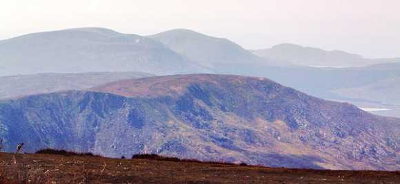
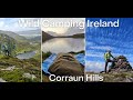
Anyway I took up by the old water tower through a gate onto the Lookout Loop and within minutes was making elevation over the beautiful Clew Bay. Although my destination was Claggan MNET, I wanted to pick off the lower summits en route and make it a really fruitful walk so I went up to Dooghill and then on to Claggan MWT. The navigation was somewhat serpentine and I was moving slowly as I had 14kg on my back with plans to overnight on the hill, and being solo didn't want to go arse over head. The views up here are stupendous and even more so when you reach CMNET which squeaks in as an Arderin at 501m. You have the Nephin Begs, The Corranabinnia horseshoe, Clew Bay, The Reek and it's attendants, Islands' Clare and Achill and another under-rated gem unexplored by many, the Corraun sub-range.
By 19.00 hours I was at my objective surveying the area in an attempt to find a suitable pitch, knowing that the wind was to rise by morning. On the lip of the NE face I got a somewhat less level than desired spot, put up my tent, put on the stove and ate my supper, happy as only a man on a mountain can be.
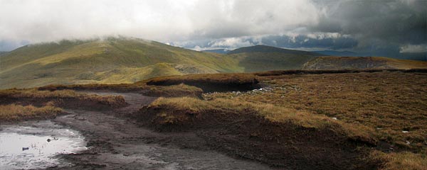
I had a superb view over Lough Anaffrin and across the vast wetness of the bogs and lofty mountains, and happily retired to my sleeping bag. Sleep was somewhat hit and miss as wind and rain showers scudded over me that night, and I arose at 06.00 to a monochrome world of low cloud. My stove decided to misfire and I struck camp coffeeless, but nonetheless cheerful. It was a different place to the day before, the views were gone and I had to push hard into the unrelenting wind and murk to continue. It was a world of grey fog crossing the peat hags and navigation was tricky but I got to Maumthomas SWT . I had originally planned to go to it's NE summit too,but the weather was just way too nasty now. I followed the spur SE off the hill for my descent, it was generally easy going underfoot, here and there having to dodge the peat hags.
I was into the teeth of the wind here and was glad to eventually reach the turf cutters tracks and from there the 'Rocky Mountain' Trail (another somewhat misnamed way). By now the cloud was above me and I could see my start point ahead, so i dallied along a bit of the aforementioned and unaptly monikered 'Greenway' to get back to the start.
In conclusion, A great walk, and if you want solitude you will be unlikely to be disappointed.
Statistics for those interested - 20km with about 600m climb and it took me about 7 hours in total, but there again, i was heavily laden and I'm never a fast walker.
A 9/10 for me. Linkback: mountainviews.ie/summit/452/comment/23872/
Read Less
Read More
EDIT Point of Interest
text
Videos


Recent Contributions
x
Conditions and Info
Use of MountainViews is governed by conditions and a privacy policy.
Read general information about the site.
Opinions in material here are not necessarily endorsed by MountainViews.
Hillwalking is a risk sport. Information in comments, walks, shared GPS tracks or about starting places may not be accurate for example as regards safety or access permission. You are responsible for your safety and your permission to walk.
See the credits and list definitions.

OSi logo
OSNI/LPS logo
Open Street Map
(Various variations used.)
British summit data courtesy:
Database of British & Irish Hills