Donation Request 2024

DONATE
Members and Supporters, the MountainViews Committee requests your help to meet the costs of the website and of other activities such as insured events or publications.
You do not have to be logged in to donate.
Features
Nearby features appear when you click the map.
Declutter tracks on map.
Place Search
Video
X
Pub: by
Partry & Joyce Area , Cen: Maumtrasna Subarea
Feature count in area: 27, by county: Mayo: 15, Galway: 15, of which 3 are in both Galway and Mayo, OSI/LPS Maps: 37, 38, CBE, EW-CON, MSW
Highest Place: Maumtrasna 682m

Starting Places (53) in area Partry & Joyce:
Aasleagh Waterfall CP, An Móinín Mór, Ballydoo Lough, Barrevagh Bridge, Bealanabrack River Tributary, Black Rock, Bohaun, Bracklagh, Buckaun, Bunduvowen, Cammanagh, Carraig Bar, Carrowrevagh Lough, Clonbur, Cummer, Derrassa, Derrinkee Wood, Doon Rock, Failmore River, Finny Church, Fooey River Road, Glendavock, Glenmask, Glennacally Bridge, Glensaulmore Trailhead, Glentraigue, Gowlaunlee Lake, Keelkill North, Killeennimat Burial Ground, Knockaunnabausty (Cnocán na bPáistí), Knocknafaughy SW, Lecarrow, Leenane, Leenane Hotel, unuseableLeenane R336, Lough Nambrackkeagh, Maum Bridge Road Lower, Maum Bridge Road Mid, Maum Bridge Road Upper, Mount Gable CP, Otter Pool, Owenbrin Bridge, Owenbrin Tributary, Owenduff River, Red Island, RIC Barracks Ruin, Rinavore East, Rinavore SW, Shanafaraghhaun Cross, Sheeffry Pass, Tawnyard Lough, Teevinish West, The Larches Pub

Summits & other features in area Partry & Joyce:
Cen: Finny: Glenbeg East 372m
Cen: Knocknafaughy: Knocknafaughy 254m, Rinavore 426m
Cen: Maumtrasna: Barnahowna 516m, Buckaun East 495m, Glennagleragh Mtn 617m, Knocklaur 518m, Maumtrasna 682m, Maumtrasna North-East Top 572m, Tullymorehill 279m
N: Ballintober Hills: Bohaun 393m, Corveagh 233m, Croaghrimkarra 271m, Keelkil 239m
SE: Cornamona: Mount Gable 417.8m, Bohaun 424m, Knocknagussy 456m
SW: Bunnacunneen: Ben Beg 560m, Bunnacunneen 575m, Bunnacunneen South Top 539m, Bunnacunneen SE Top 479m, Lugnabrick SW Top 494m, Lugnabrick NE Top 494m
W: Devilsmother: Devilsmother 645m, Devilsmother South Top 509m, Devilsmother North Top 595m, Devilsmother Far North Top 601m

Note: this list of places may include island features such as summits, but not islands as such.
Rating graphic.
Knocklaur, 518m Mountain Cnoc Láir A name in Irish,
Place Rating ..
(prob. Ir. Cnoc Láir [PDT], 'middle hill'), Binn Ghlas, Galway/ Mayo County in Connacht province, in Arderin, Irish Best Hundred Lists, Knocklaur is the 512th highest place in Ireland.
Grid Reference L93561 63112, OS 1:50k mapsheet 38
Place visited by: 119 members, recently by: srr45, Carolyn105, Krzysztof_K, farmerjoe, Niamhq, bryanjbarry, chelman7, Taisce, Sweeney, TommyMc, ryanguinness10, padstowe, elizauna, Ianhhill, DNicholson
I visited this place: NO (You need to be a logged-in member for this.)
Longitude: -9.609229, Latitude: 53.607378, Easting: 93561, Northing: 263112, Prominence: 43m,  Isolation: 1.9km
ITM: 493506 763152
Bedrock type: Sandstone & conglomerate, ignimbrite, (Mweelrea Formation)
Notes on name: The name Knocklaur is marked about 1 km E of this peak on the Discovery map. As there is no summit at this point, it is not clear exactly which hill the name applies to.
  Short or GPS IDs, 6 char: Kncklr, 10 char: Knocklaur

Linkback: https://mountainviews.ie/summit/414/
Gallery for Knocklaur (Cnoc Láir) and surrounds
Summary for Knocklaur (Cnoc Láir): A dramatic location
Summary created by wicklore 2011-05-14 13:34:55
            MountainViews.ie picture about Knocklaur (<em>Cnoc Láir</em>)
Picture: Knocklaur (r) with Maumtrasna beyond
Knocklaur is roughly the midpoint on the ridge connecting Maumtrasna and Devilsmother. This explains its name, Knocklaur, meaning ‘middle hill’. There is a steady bog sweeping up to the summit from the south, while to the north of the summit ridge the ground plummets away in sharp cliffs and extremely steep slopes. The views from Knocklaur are fantastic, especially across to the ridge containing Devilsmother and Devilsmother North Top to the west, and the vast bulk of Maumtrasna to the east. Knocklaur has a large spur that juts out north into the Glennacally valley, although the severity of the gradient on this spur would prevent access to Knocklaur this way for all but the most experienced summiteers.

It can be approached from the Devilsmother ridge by joining the Knocklaur ridge at A (L920 630). An easier alternative is to park at Fooey Rd (L936 611) which is the end of a minor road at a little hamlet. A climb of 460 metres over 2 km can be made over a mixture of bog and grassland, with several fences and a few streams to negotiate. The trudge over bog gives way to the dramatic drops into the Glennacally Valley below as you reach the summit. Caution is required at the summit or on the ridge due to dangerous drops to the north.
Linkback: mountainviews.ie/summit/414/comment/5173/
Member Comments for Knocklaur (Cnoc Láir)
Comment create / edit display placeholder

            MountainViews.ie picture about Knocklaur (<em>Cnoc Láir</em>)
Picture: The ridge from Devilsmother to Maumtrasna, with Knocklaur in the middle
Best view of the Devil
by wicklore 30 Nov 2010
Knocklaur is roughly the midpoint on the ridge connecting Maumtrasna and Devilsmother. This explains its name, Knocklaur, meaning ‘middle hill’. The ridge itself has extremely steep drops along its northern side, while the southern side of the ridge is gentler. It is easy to keep well away from the steep northern drops as the ridge is quite broad. While Knocklaur can be climbed directly from the south, it is more likely to be climbed either from the Devilsmother ridge or from Maumtrasna. The views from Knocklaur are fantastic, especially across to the ridge containing Devilsmother and Devilsmother North Top to the west, and the vast bulk of Maumtrasna to the east. Knocklaur has a large spur that juts out into the Glennacally valley, although the severity of the gradient on this spur would prevent access to Knocklaur this way for all but the most experienced summiteers.

Those on a long walk can start from B (L935 655), where there is room to park a couple of cars beside a bridge. A local sheep farmer said access to the valley from here is permitted. From here cross the river and follow a fence into the valley for several hundred metres before heading directly up the steep wet slopes to gain the Devilsmother ridge. The ridge is wide and heathery, and can be followed to A (L920 630) where it connects to the ridge to Knocklaur and Maumtrasna. The final haul up to Knocklaur is quite steep, although a handy fence can provide support. If including the two Devilsmother tops first, Knocklaur can be reached in about three hours.

For a quicker ascent park at Fooey Rd (L936 611) which is the end of a minor road at a little hamlet. Although access is allowed through the farmland here, always ask first at any of the houses. From here it is a climb of 460 metres over 2 km distance to the summit of Knocklaur directly to the north. This route crosses a mixture of bog and grassland, with several fences and a few streams to negotiate. This approach would no doubt offer the greatest surprise as the trudge over bog gives way to the dramatic drops into Glennacally below as you reach the summit. Linkback: mountainviews.ie/summit/414/comment/6171/
Read Less
Read More

            MountainViews.ie picture about Knocklaur (<em>Cnoc Láir</em>)
Picture: Glennacally Valley of Maumtrasna
simon3 on Knocklaur
by simon3 7 May 2005
Knocklaur is an impressive spur pushing north into the Glennacally valley, or at least it is from the valley floor. Reaching it from ridge on the Maumtrasna side it's just a pull up of 40 or 50m.

Some words of caution. As so often in Ireland the north or northeasterly side of the mountain tends to be very steep. If you are trying to get off this summit to the north do not attempt the direct route down the north spur of Knocklaur -- it's very steep particularly at around elevation 250m. There is a col 540m to the West of the summit, but don't try to descend to the north there either, it' s even steeper. Your options are to descend at about C (L920 629) (see Route A on simulation) or follow the west ridge and climb onto Maghairlí an Deamhain north of it. Linkback: mountainviews.ie/summit/414/comment/1683/
Read Less
Read More

            MountainViews.ie picture about Knocklaur (<em>Cnoc Láir</em>)
First top on a Devilsmother Horseshoe
by fingalscave 27 Feb 2012
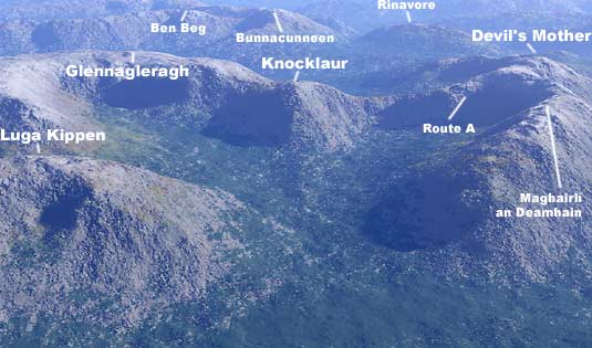
Mindful of Wicklore’s cautions of an ascent from the north and Simon3’s almost interdiction of a descent in this direction, I approached the northern spur of Knocklaur prepared if neccessary to walk around it’s base in order to find an ascent route, a line of attack so to speak.

I parked at GlCal Brg (L935 656)
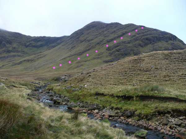
, Glennacally Bridge. This is some 8km NW of Leenaun on the N59. Going through the gate directly south of the parking area, I followed the east bank of the Glennacally river. The first sections encountered here cut right through the rock forming some dramatic channels, not what you’d expect from the map. After about 1km, the river is joined by a branch from the left, the Glenfree. This was shallow when I was there and it was easy to cross. Knocklaur’s northern spur loomed large straight ahead as I continued heading south, following fairly close to the left bank of the river. After another 1km, I crossed the river just after a ridge on the opposite bank, a section of moraine perhaps? I could see an obvious green ramp heading diagonally up the incline from the left (east) side of Knocklaur’s northern spur and up to it’s central spine. The ramp starts around D (L93838 63581) and ends on the spine at E (L93486 63545). This ramp is steep but is very do-able.

About halfway up the ramp I veered left, weaving through some rocky sections and going more directly up the slope, hands required. When I reached the spine, interested to see whether I should have stayed on my original course, I descended down towards the point where the ramp would have arrived. I didn’t go all the way down, but I don’t think there was any obstacle further down, so staying on the ramp would probably be an easier route up.

Once on the spine, it’s just a matter of some fairly easy scrambling up to Knocklaur summit.

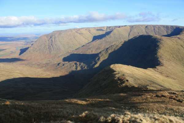
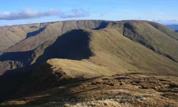
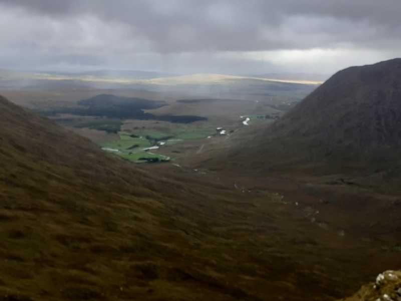
The clouds hovered around the 500m mark, so while I could see down to the cols - the western one towards Devilsmother being a particularily steep descent - Devilsmother itself, the next peak on the route, remained hidden.

Also see Track 1267 Linkback: mountainviews.ie/summit/414/comment/6682/
Read Less
Read More

Approaches from the North and East
by Onzy 26 May 2014
Knocklaur can be approached from the North at Glennacally bridge ( GlCal Brg (L93519 65641)) where there is some parking on waste ground adjacent to a bungalow surrounded by trees. Permission can be sought at the bungalow and will probably be given readily. Knocklaur can be the first hill on a circuit to also include Devilsmother and its North top.

The route south to Knocklaur crosses two streams, the Glenncally and the Glenfree, both of which can become seriously difficult to cross after rain. I would recommend crossing these at the earliest possible opportunity or you may be condemned to wander upstream of both and away to the east of your route. In fact, if doing this route again, I would cross to the west of the Glenncally river at the bridge which would outflank the Glenfree.

Fingalscave notes a ramp beginning around D (L93838 63581) and ending on the spine at E (L93486 63545). This is likely to be the best approach from north or east. Due to detours made in order to get across the river, I missed this ramp and wound up well south of the approach to the ramp - instead I looked straight up at a wall of a hill which looked staggeringly steep. I did get up but at times it felt almost vertical and I had to climb grabbing handholds of mud. Any major slip and I felt would have slid down a vertical 150m before stopping. I would strongly recommend that, if approaching Knocklaur from this direction, that you find and use the ramp rather than any other ascent.

If doing the full circuit, it is worth noting that it is much safer done clockwise; descending north or east off Knocklaur is fraught with danger. Linkback: mountainviews.ie/summit/414/comment/16074/
Read Less
Read More

            MountainViews.ie picture about Knocklaur (<em>Cnoc Láir</em>)
Picture: view of the Glenacaley valley
Up the northern spur
by markmjcampion 28 Oct 2020
Firstly, if attempting this route from Glenacally Bridge ( GlCal Brg (L935 657)) please call into the farmer across the road and ask for permission to park on the obvious waste ground beside the bridge. He has installed a No Parking Sign but he's a decent man and won't have a problem with you parking if your group is small. The route up Knocklaur from here involves a very pleasant saunter along the banks of the Glenacally river for nearly a km. There are a few impressive mini gorges and falls en route. thereafter, you need to make a decision...take on the northern spur or skirt it to the west or east. i felt in good shape so decided to head straight up the spur. it's a tough but exhilarating climb involving some minor scrambling and route finding but in clear weather it poses no threat to a fit hiker with a head for heights. I would nae recommend it in poor visibility though! Once up the steep spur it's a short walk over to the summit from where the views are spectacular! Linkback: mountainviews.ie/summit/414/comment/21106/
Read Less
Read More
EDIT Point of Interest
text
Videos


Recent Contributions
x
Conditions and Info
Use of MountainViews is governed by conditions and a privacy policy.
Read general information about the site.
Opinions in material here are not necessarily endorsed by MountainViews.
Hillwalking is a risk sport. Information in comments, walks, shared GPS tracks or about starting places may not be accurate for example as regards safety or access permission. You are responsible for your safety and your permission to walk.
See the credits and list definitions.

OSi logo
OSNI/LPS logo
Open Street Map
(Various variations used.)
British summit data courtesy:
Database of British & Irish Hills