Donation Request 2024

DONATE
Members and Supporters, the MountainViews Committee requests your help to meet the costs of the website and of other activities such as insured events or publications.
You do not have to be logged in to donate.
Features
Nearby features appear when you click the map.
Declutter tracks on map.
Place Search
Video
X
Pub: by
Caha Mountains Area , E: Glengarriff Subarea
Feature count in area: 57, by county: Cork: 32, Kerry: 36, of which 11 are in both Cork and Kerry, OSI/LPS Maps: 83, 84, 85, 88
Highest Place: Hungry Hill 682m

Starting Places (51) in area Caha Mountains:
Ardgroom, Barley Lake North, Bere Island Pier, Caha Pass, Canshanavoe South, Carriganine, Cashelkeelty Stone Circles Carpark, Castletownbere Lifeboat Harbour, Clashduff River Farm, Coolieragh Harbour Road, Coomadayallig Lake Road N, Coomadayallig Lake Road S, Cooryeen Lane, Cummer Lough East Road, Derreenataggart Stone Circle Road, Dromoghty Lough North, Dunboy Wood, Esk Boreen, Eyeries, Fehanah Lane, Garinish Island Pier, Glantrasna Bridge, Glenbeg Lough N, Glengarriff, Glengarriff Nature Reserve CP, Gleninchaquin Waterfall, Gowlaun Lough, Healy Pass, Healy Pass Hairpin, Ilnacullin Car Park, Kenmare Bridge, Knockacullin Lane, Leahill Bog, Leitrim Beg Standing Stone, Lough Inchiquin SE, Magannagan Stream, Molly Gallivan's Visitor Centre, Nora's Cottage, Old Lansdowne School, Owgarriff River Lane, Peg's Shop, Pooleen Wood Car Park, Red Trout Lake, Reenroe Bridge, River Drimminboy Track, Rossmackowen Bridge, Rossmackowen Cemetery, Shronebirrane Farm, Shronebirrane Road, Toberbanaha, Turner's Rock Tunnel

Summits & other features in area Caha Mountains:
Cen: Hungry Hill: Coombane 510m, Derryclancy 554m, Hungry Hill 682m
Cen: Knockowen: Cushnaficulla 594m, Glenkeel Top 417m, Knockastumpa 398m, Knockeirky 577m, Knockeirky South Top 523m, Knockowen 658m, Stookeennalackareha 412m
E: Glengarriff: Derrynafulla SW 375m, Gowlbeg Mountain 362m, Nareera 530m, Nareera North Top 503m, Nareera South-West Top 505m, Shrone Hill 283m, Sugarloaf Mountain 574m, Sugarloaf Mountain Far West Top 560m, Sugarloaf Mountain West Top 565m
N: Coomnadiha: Baurearagh Mountain 489m, Caha Far SE Top 555m, Caha SE Top 585m, Coomnadiha 644m, Coomnalack Top 435m, Cummeenbaun 510m, Droppa 522m, Killane Mountain 537m, Killane Mountain South-West Top 533m, Knockagarrane 414m, Knockreagh 500m
N: Knockeirka: Barraduff Mountain 400m, Killaha Mountain 400m, Knockeirka 426m
N: Knocknagorraveela: Derrysallagh 410m, Feorus East 474m, Knocknagorraveela 507m, Knocknagorraveela NE Top 464m
N: Lauragh: Knockanoughanish 386m, Knockatee 330m
S: Castletownbere: Disert 205m, Knockanallig (Bear Island) 267m
W: Ardgroom: Derryvour Hill 160m
W: Eskatarriff: Coomacloghane 599m, Eskatarriff 600.5m, Eskatarriff East Top 532.7m, Knocknaveacal North Top 509.1m, Knocknaveacal South Top 507.2m, Lackabane 603m, Tooreenbaha 408.7m, Tooreennamna 524m, Tooth Mountain 592m
W: Knocknagree: Knocknagree 586m, Knocknagree East Top 461m, Knocknagree SE Top 442m, Lackawee 572m, Maulin 621m, Maulin North Top 579m

Note: this list of places may include island features such as summits, but not islands as such.
Rating graphic.
Sugarloaf Mountain Far West Top, 560m Mountain Gabhal Mhór (mullach i gcéin thiar) A name in Irish,
Place Rating ..
For origin of name, see Sugarloaf Mountain., Cork County in Munster province, in Arderin Lists, Sugarloaf Mountain Far West Top is the 393rd highest place in Ireland.
Grid Reference V86104 53253, OS 1:50k mapsheet 85
Place visited by: 92 members, recently by: maoris, Ainegavgav, Krzysztof_K, amgall, John.geary, mountainmike, garrettd, annem, eiremountains, JohnRea, daitho9, Superterence, jackos, Ulsterpooka, millsd1
I visited this place: NO (You need to be a logged-in member for this.)
Longitude: -9.649392, Latitude: 51.720894, Easting: 86104, Northing: 53253, Prominence: 85m,  Isolation: 0.2km
ITM: 486044 553346
Bedrock type: Purple & green sandstone & siltstone, (Caha Mountain Formation)
Notes on name: Previously Toberavanaha in MV.
  Short or GPS IDs, 6 char: Sgr560, 10 char: SgrlfMntnF

Linkback: https://mountainviews.ie/summit/341/
Gallery for Sugarloaf Mountain Far West Top (Gabhal Mhór (mullach i gcéin thiar)) and surrounds
Summary for Sugarloaf Mountain Far West Top (Gabhal Mhór (mullach i gcéin thiar)): Two for the price of one?
Summary created by jackill 2012-07-30 07:36:24
            MountainViews.ie picture about Sugarloaf Mountain Far West Top (<em>Gabhal Mhór (mullach i gcéin thiar)</em>)
Picture: From Nareera, Sugarloaf west with Beara way and L.Toberavanaha
Park on the roadside at Magn Str (V91700 54569) and follow Beara Way on a well marked track through the woods for 4.5 kms before the climb up the back of the valley under the Sugarloaf. The Beara way is shown by a series of yellow posts up to and past Lough Tobernavaha. Just before the lake turn north and climb the rocky shelf to the summit.
The summit is a series of rocky shelves jutting sideways from the heather
Linkback: mountainviews.ie/summit/341/comment/5101/
Member Comments for Sugarloaf Mountain Far West Top (Gabhal Mhór (mullach i gcéin thiar))
Comment create / edit display placeholder

            MountainViews.ie picture about Sugarloaf Mountain Far West Top (<em>Gabhal Mhór (mullach i gcéin thiar)</em>)
Picture: I would wish to be with you in body,as I shall be in spirit
Healy and Parnell remember Mrs O
by jackill 31 Aug 2010
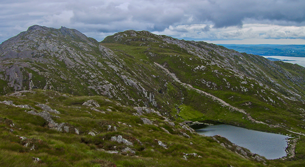
Sugarloaf West as Simon mentions has two possible tops .The photo here is taken from the lower one looking down to Glengarriff.
As you enter Glengariff from Bantry on your left hidden by trees is the former site of Roches Royal Hotel.
It was here that Tim Healy, the future first Governor-General of the Irish Free State, was arrested for his activities with the Land League. Renowned for his wit and sharp tongue he went from being an ardent supporter of Parnell to one of his fiercest critics.
When Parnell asked his colleagues at one party meeting "Who is the master of the party?", Healy famously retorted with another question "Aye, but who is the mistress of the party?" referring to Parnells ongoing affair with Mrs O'Shea.
Tim Healy also gives his name to the nearby Healy Pass.
Last word though to Robert Llyod Praeger who, writing almost 75 years ago, summed up the magic of this area.
"Best of all is it to penetrate on foot the wild region of hill and cliff and lake lying just west of Glengarriff, not built on such a massive or lofty scale as Macgillycuddy's Reeks, but surpassing them for variety and sheer beauty.
Enter this enchanted region by way of Barley lake or Adrigole glen with strong boots and a raincoat to exorcise the demons of air and water, and I would wish to be with you in body, as I shall be in spirit" Linkback: mountainviews.ie/summit/341/comment/6067/
Read Less
Read More

            MountainViews.ie picture about Sugarloaf Mountain Far West Top (<em>Gabhal Mhór (mullach i gcéin thiar)</em>)
simon3 on Sugarloaf Mountain Far West Top
by simon3 27 May 2003
Toberavanaha overlooks the wild glacial valley to the north-east as shown in this picture. The nearer lake rejoices in the anglicised name of Eekenohoolikeaghaun, the further is Derreenadarodia. The rough “corduroy” texture of the rock and the bare uninhabited nature of the valley make it appear so wild a place that you would think that it had only just been carved out by the glaciers. The high ground to the left of the picture is part of the lake studded Glenlough Mountain – really a broad plateau running north-south for over 2k. Linkback: mountainviews.ie/summit/341/comment/519/
Read Less
Read More

            MountainViews.ie picture about Sugarloaf Mountain Far West Top (<em>Gabhal Mhór (mullach i gcéin thiar)</em>)
simon3 on Sugarloaf Mountain Far West Top
by simon3 27 May 2003
Toberavanaha has two possible candidates for main summit, one to the north and west, one to the east. According to my best averaged value from the GPS, the height is at around 568 for the north and west one as against 564 for the east one, but I would be open to correction. What’s interesting about this place is that compared to the well known Sugarloaf that is so near, Toberavanaha is relatively unvisited, with a feel of remoteness. As we visited it we saw a fox.

Our photo shows Lough Toberavanaha with part of the Bantry Bay coastline east of Adrigole in view. Linkback: mountainviews.ie/summit/341/comment/518/
Read Less
Read More

wellaway on Sugarloaf Mountain Far West Top
by wellaway 3 Oct 2006
"The nearer lake rejoices in the anglicised name of Eekenohoolikeaghaun, the further is Derreenadarodia."
When we were small boys, we used to do a bit of rock climbing on the cliffs on the way into Lough Derreendarodia.(& party afterwards in Doc Ryans, just so you'll know our generation) I think we called the crag Ozymandias, dont know why. Last time I looked 10 years ago the carabiner was still stuck in a crack there.
Anyway one of th local farmers told me the name was anglicised from Loch Dereen dá Bó deag. i.e 12 cow lake. The legend involved one finding a herb that grew near the lake which enabled you to see the 12 cows and turn them back into 12 beautifull maidens or something. I have forgotten. Linkback: mountainviews.ie/summit/341/comment/2521/
Read Less
Read More

Nice views over Adrigole
by thomas_g 29 Jul 2012
Unfortunately it looks like the access at A (V91465 53888) isn't an option any more - there are multiple no access signs and the gate is covered in barbed wire, just in case you didn't get the hint from the signs. As an alternative I parked on the roadside at Magn Str (V91700 54569) (1 car) and followed the old Beara Way towards Sugarloaf (which is visible from miles away). The summit is a few hundred metres off the new Beara Way track. Linkback: mountainviews.ie/summit/341/comment/14735/
Read Less
Read More
EDIT Point of Interest
text
Videos

Recent Contributions
x
Conditions and Info
Use of MountainViews is governed by conditions and a privacy policy.
Read general information about the site.
Opinions in material here are not necessarily endorsed by MountainViews.
Hillwalking is a risk sport. Information in comments, walks, shared GPS tracks or about starting places may not be accurate for example as regards safety or access permission. You are responsible for your safety and your permission to walk.
See the credits and list definitions.

OSi logo
OSNI/LPS logo
Open Street Map
(Various variations used.)
British summit data courtesy:
Database of British & Irish Hills