Members and Supporters, the MountainViews Committee requests your help to meet the costs of the website and of other activities such as insured events or publications.
Feature count in area: 16, all in Kerry,
OSI/LPS Maps: 71, EW-DC, EW-DE
Highest Place: Baurtregaum 849.7m
Starting Places (15) in area Slieve Mish: Caherconree Scenic Route, Derrymore West Trail, Doonore South, Emlagh Cross, Emlagh Wood, Feighatidura Cove, Glanaskagheen Wood, Greenlawn Cross, Laharn Viewpoint, Lougher, Maum Cross, Maumnahaltora Cross, R561 Lissaroe, Tonavane Cross, Tonavane Walk Kerry Camino
Summits & other features in area Slieve Mish: Cen: Baurtregaum: Baurtregaum 849.7m, Baurtregaum Far NE Top 601.2m, Baurtregaum NE Top 818.5m, Baurtregaum NW Top 723m, Caherconree 835m, Castle Hill 600m, Gearhane 792m E: Barnanageehy: Barnanageehy 561m W: Aughils: Beenduff 515m, Caherbla 585.2m, Emlagh 483m, Knockbrack 459m, Knockmore 565m, Lack Mountain 465m, Moanlaur 566m W: Camp: Corrin 332m
Note: this list of places may include island features such as summits, but not
islands as such.
Baurtregaum NE Top, 818.5mMountain Barr Trí gCom (mullach thoir thuaidh) A name in Irish,
Place Rating ..
For origin of name, see Baurtregaum., Kerry County in Munster province, in Arderin Beg, Vandeleur-Lynam Lists, Baurtregaum NE Top is the third highest mountain in the Slieve Mish area and the 33rd highest in Ireland.
Grid Reference Q75524 08189,
OS 1:50k mapsheet 71 Place visited by: 174members, recently by: kelleher, rhw, maoris, SeanPurcell, knightsonhikes, ToughSoles, Moirabourke, DeirdreM, chelman7, mdehantschutter, Ansarlodge, davsheen, eugeneryan959, Beti13, Sarahjb
I visited this place: NO (You need to be a logged-in member for this.)
Short or GPS IDs, 6 char: BrtrNE, 10 char: BrtrgmNETp Linkback: https://mountainviews.ie/summit/32/
Gallery for Baurtregaum NE Top (Barr Trí gCom (mullach thoir thuaidh)) and surrounds
Summary
for Baurtregaum NE Top (Barr Trí gCom (mullach thoir thuaidh)):
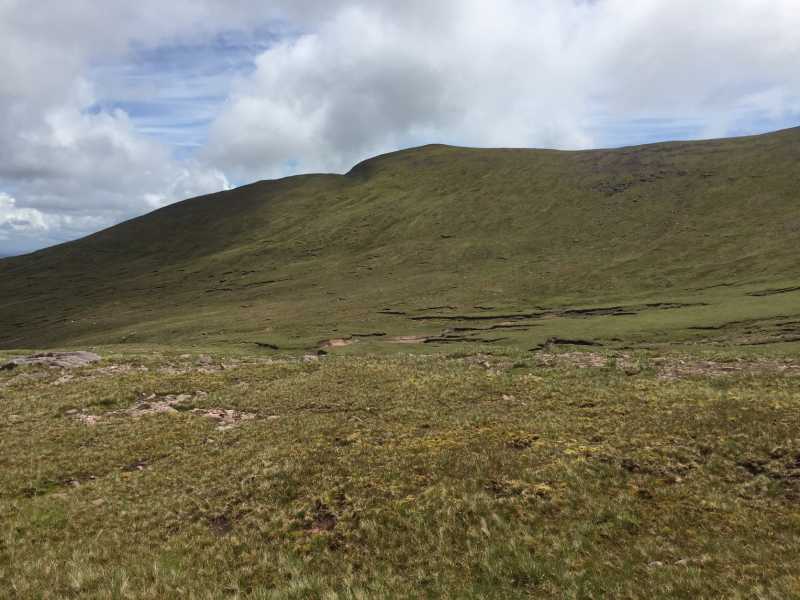
Baurtregaum satellite summit
Summary created by liz50
2017-06-08 18:59:22
Picture: Baurtregaum North East top
Difficult to access directly it is generally approached from Baurtregaum main top which is only 700m to the SW. Can also be approached from Baurtregaum far north east top which can be gained following a steep ascent from the Dingle way to the North, leaving the way at A (Q77992 10599) or B (Q760 105). Could also be approached from the south from Castle Hill
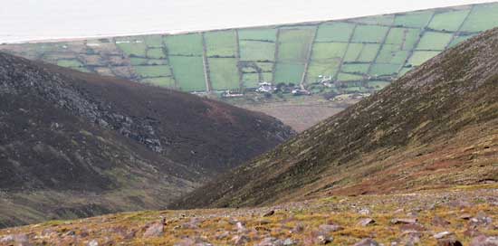
Baurtregaum North East, BNE, is only about 700m NE of Baurtregaum proper, however from it you can get a much better view of the coastline, in this photo just west of Derrymore Strand. From this oblique angle the fields boundaries look like they will converge somewhere at the foot of the mountain. ( Informed by the photos in Trail Master, I can tell you they do converge a little, but this is exaggerated by the viewpoint.)
The slope on the left is Gearhane, the interlocking slope on the right is the side of Scragg, a ridge from Baurtregaum that does not have a top. BNE also has good views to the NE of Tralee. Linkback: mountainviews.ie/summit/32/comment/2059/
Use of MountainViews is governed by conditions and a privacy policy.
Read general information about the site. Opinions in material here are not necessarily endorsed by MountainViews.
Hillwalking is a risk sport. Information in comments, walks, shared GPS tracks or about starting places may
not be accurate for example as regards safety or access permission. You are responsible for your safety and your permission to walk.
See the credits and list definitions.


 Our Facebook page.