Cookies.
This website uses cookies, which are small text files that the website puts on your device to facilitate operation. Cookies help us provide a better service to you. They are used to track general user traffic information and to help the website function properly.
Features
Nearby features appear when you click the map.
Declutter tracks on map.
Place Search
Video
X
Pub: by
Mourne Mountains Area , Cen: Loughshannagh Subarea
Feature count in area: 58, all in Down, OSI/LPS Maps: 20, 29, EW-CLY
Highest Place: Slieve Donard 849m

Starting Places (33) in area Mourne Mountains:
Alex Steddom Tree, Aughrim Airstrip, Ben Crom Dam, Bloody Bridge Car Park, Carlingford Greenway, Carrick Little, Crocknafeola Wood, Crotlieve Mountain, Donard Car Park Newcastle, Drummanmore Picnic, Fofanny Reservoir, Forest Office CP, Gamekeepers Lodge CP, Happy Valley Trassey Rd, Hen Mountain CP, Leitrim Lodge CP, Mayo Road Corner, Meelmore Lodge, Newcastle Harbour, Ott CP, Red Bog Road, Rourkes Park, Sandy Brae, Silent Valley Reservoir Head Rd, Slieve Donard Trail Head, Slieve Foye Viewing Point, Slievefoy Forest CP, Spelga Dam E, Spelga Dam N, Spelga Dam S, Trassey Car Park, Two Mile River CP, Yellow Water Park

Summits & other features in area Mourne Mountains:
Cen: Loughshannagh: Ben Crom 526m, Carn Mountain 585.2m, Carn Mountain North Top 553.7m, Doan 592.6m, Ott Mountain 526.8m, Slieve Loughshannagh 617m, Slieve Muck 670.4m, Slievenaglogh 445m
E: Binnian: Slieve Binnian 745.9m, Slieve Binnian East Top 639m, Slieve Binnian North Top 678m, Slieve Binnian North Tor 682.5m, Wee Binnian 460m
E: Donard: Chimney Rock Mountain 656m, Crossone 540m, Millstone Mountain 460m, Rocky Mountain 524m, Slieve Donard 849m
E: Lamagan: Cove Mountain 654.8m, Slieve Beg 595.9m, Slievelamagan 702.2m
N: Bearnagh: Slieve Bearnagh 739m, Slieve Bearnagh North Tor 680m, Slieve Meelbeg 701.9m, Slieve Meelmore 687m
N: Castlewellan: Slievenalargy 280m, Slievenaslat 272m
N: Commedagh: Slieve Commedagh 767m, Slieve Corragh 641.9m, Slievenaglogh 584.4m, Slievenaglogh East Top 571m
N: Croob: Cratlieve 429m, Slieve Croob 534m, Slievegarran 391m, Slievenisky 446m
N: Rathfriland: Knockiveagh 235m
S: Kilkeel: Knockchree 306m
S: Rostrevor: Crenville 460m, Finlieve 578m, Slievemartin 485m, Slievemeel 420m, Slievemeen 472m
W: Hilltown: Gruggandoo 382m, Slieveacarnane 296m
W: Slievemoughanmore: Crotlieve Mountain 347m, Eagle Mountain 638m, Rocky Mountain 404m, Shanlieve 626m, Slievemoughanmore 560m, Tievedockaragh 473m, Wee Slievemoughan 428m
W: Spelga: Butter Mountain 500m, Cock Mountain 504m, Cock Mountain South-West Top 505m, Hen Mountain 354m, Pigeon Rock Mountain 534m, Pigeon Rock Mountain South Top 530m, Slievenamiskan 444m

Note: this list of places may include island features such as summits, but not islands as such.
Rating graphic.
Doan, 592.6m Mountain Dún Maol Chobha A name in Irish,
Place Rating ..
(Ir. Dún Maol Chobha [PNNI], 'Maol Chobha's fort'), Down County in Ulster province, in Arderin Lists, Doan is the 311th highest place in Ireland.
Grid Reference J30226 26215, OS 1:50k mapsheet 29
Place visited by: 391 members, recently by: Dee68, Henning86, davidrenshaw, Magic, Carolineswalsh, Alanjm, ElaineM76, garybuz, SenanFoley, Sonyalaw, Kaszmirek78, Timmy.Mullen, Lyner, Nailer1967, Lucky1
I visited this place: NO (You need to be a logged-in member for this.)
Longitude: -6.006784, Latitude: 54.168443, Easting: 330226, Northing: 326216, Prominence: 118.6m,  Isolation: 1.1km
ITM: 730146 826221
Bedrock type: Granite granophyre, (Mourne Mountains granite)
Notes on name: There is no record of an actual fort here, so the name probably comes from the imagined resemblence of the craggy summit to a fortress. For origin of name, see PNNI for info on Maol Chobha.
  Short or GPS IDs, 6 char: Doan, 10 char: Doan

Linkback: https://mountainviews.ie/summit/290/
Gallery for Doan (Dún Maol Chobha) and surrounds
Summary for Doan (Dún Maol Chobha): A little gem among the Mourne jewels.
Summary created by Harry Goodman, simon3 2014-05-30 20:37:56
            MountainViews.ie picture about Doan (<em>Dún Maol Chobha</em>)
Picture: Doan (from Carn) and Lough Shannagh, Slieve Donard and Slievelamagan in background (left)
A popular starting point is the car park on the Slievenaman Road Ott CP (J280 279). Cross the road and once over the stile go SE along a good track. About 150m along, at a fork, go right and follow the track uphill to its end before heading E up to the col A (J291 268) between Carn and Slieveloughshannagh. Cross the stile over the Mourne Wall and contour around NE along a stony track to about B (J296 269) some 500m along. Leave the track and go SE down to cross a broad boggy saddle and then gently up through some peat hags and sandy ground to pick up a track C (J300 268) going ESE more steeply uphill. In good conditions the line of the track is clear to see and leads directly towards the top. Once the rocky summit area is reached the easiest line to take is to go around to the left before finally climbing up over the rocks to the top. The view from the top is a 360 degree panorama sweeping around from the Silent Valley Reservoir W to Slieve Muck and along past Carn, Slieveloughshannagh, Meelbeg,Meelmore, Bernagh, before turning E to Slievelamagan and the vast bulk of Binnian. A magnificent place to simply sit and enjoy. Return by way of ascent. Alternatively start at the Banns Road car park Gmkeep (J284 215) and follow the track N to L Shannagh. Go around its E side and then climb up NE to the ridge before making for the top.
Linkback: mountainviews.ie/summit/290/comment/5050/
Member Comments for Doan (Dún Maol Chobha)
Comment create / edit display placeholder

Geo on Doan
by Geo 6 Mar 2010
Straw Poll, Is this the Mourne's real heart? Who else finds this their favourite of Down's pinnacle's? Answers on a postcard... Up here today for perhaps the fourth time, and found that there is another way besides the tried and tested from the Lough Shannagh side. We had come from the South off the Bann's Road after Slieve Muck, gone NE on the track which goes across the Shannagh river at the waterfall or thereabouts. The waterfall is a little gem and worth a few minutes of anyone's precious life. Anyway, to get back to the point we went on to Doan finding, by accident a track winding up from the SE. I couldn't believe that I'd never realised it's existence. DOH! to quote the great philosopher Homer (Simpson). I enjoyed this way up as one can do a little scrambling to add spice to the walk. Oh! and it makes a great stopping point for lunch, seating for at least fifty. Linkback: mountainviews.ie/summit/290/comment/4477/
Read Less
Read More

            MountainViews.ie picture about Doan (<em>Dún Maol Chobha</em>)
Picture: Doan from Slieve Muck
gerrym on Doan
by gerrym 13 Nov 2005
Doan, along with Ben Crom, is easy to overlook if walking along the higher hills surrounding it and was one of the last tops for me to climb in the Mournes. Having been up once I have made a point to go back on several occasions, working the climb into different routes. I have approached from the Ott track each time, giving quick access with not too much effort along fairly easy ground. To make up for this there are numerous options to explore areas of the Mournes from different angles. The top of Doan is quite small and on a windy day with ice or snow thrown in it is more exciting than its imposing neighbours. Can drop down the NE side for a quicker approach to Ben Crom over more challenging ground than following the tracks. From Ben Crom I have walked NE high above Ben Crom resevoir and climbed Slieve Bernagh away from the comfort of the wall. Picking up the wall a good circuit over Meelmore, Meelbeg and Slieveloughshannagh will come back to the Ott track. The most satisfying option I have taken is dropping down from Ben Crom to the resevoir, crossing the dam and climbing steeply up Slieve Binnian - wee Binnian - Moolieve and then crossing over the dam at Silent valley and climbing Slievenaclogh (over difficult ground until wall is reached). From here the track running up to Lough Shannagh brought me full circle around Doan, with a great time skirting its sandy shoreline on the way back to the col and the Ott track again (a long day which taught me to always have a headtorch in the pack as trying to walk in the dark isn't too pleasant). If you have left Doan as I had, try and build it into a more challenging outing or leave it to a rough day to fully appreciate the top. Linkback: mountainviews.ie/summit/290/comment/819/
Read Less
Read More

            MountainViews.ie picture about Doan (<em>Dún Maol Chobha</em>)
Picture: View from Doan
ssames on Doan
by ssames 10 Dec 2008
In the morning we stepped on some ice. Maybe it can be considered strange but I do not thing I am alone when I say that I delight in the sound of crunching ice and snow underfoot. I felt like a child as I played on the mountainside.
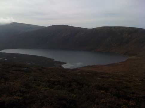
We pitched tents at the side of a Loughshannagh deep in the Mourne Mountains in conditions which should have felt cold be actually felt pleasant. A lone Raven krunked nearby, welcoming us to her home. No wind.
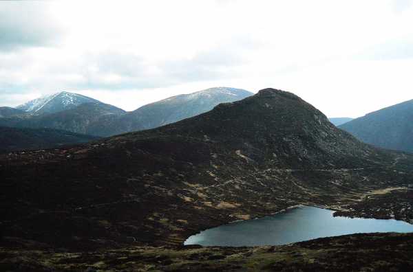
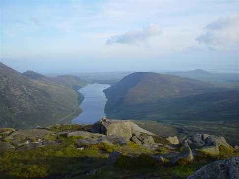
On the side of Doan we practised our rope work and discussed safe anchors as the sun went down and revealed a range or deep colours that sank into our souls. These are the moments we are here for, in these mountains and in this life. Way better than Saturday night TV.
The temperature plummeted dramatically as the shadowed cloaks of the mountains dropped on us. It was already -2 as we shoveled our dinner into us. Dessert; guilt free.
Night navigation was practiced by a waxing moon. The moonlight cast long shadows and the stars rose and set like a clockwork blanket. The terrain was interesting, twice I had the rapid thought “hello ground” as I fell into hidden holes that left my armpits at ground level and my feet caught deep underground. The moon and stars kept turning.
Returning to camp took us past the frozen half of the Loughshannagh. We turned off the head-torches and threw chunks of ice and rocks across the half inch thick surface. We listened to the sliding ice and strained our ears for the splash. No matter how hard we threw, we heard no splash. Later on, the next day, we saw some of our rocks sitting on their own on the lake’s surface. Waiting for the moment of inevitable plop and sink when no one would be near to hear it. It was very cold.
Before crawling into our bags for the long cold night we gathered together and had a little tent party with laughter and a selection of fine cheeses. This was a luxury wild camp.
After a cold night that we have been told sank to -5, I woke up to grab my gas canister and nurse it to life while I had a brief snooze and then muesli in bed. Sleeping and hugging my cooker made me feel like a mountaineer. Linkback: mountainviews.ie/summit/290/comment/3475/
Read Less
Read More

            MountainViews.ie picture about Doan (<em>Dún Maol Chobha</em>)
Picture: View across to Carn Mountain with Lough Shannagh below
wicklore on Doan
by wicklore 13 Oct 2008
Leaving the summit of Ben Crom I headed NW keeping the ridge on my left. I tackled the bog and followed the 450 metre contour line around until I crossed the Bencrom River at D (J307 265). The going was boggy and difficult at times. After the river the ground improved and I then headed SW to begin the climb up to Doan. Reaching the slope I moved to the west and picked up a rocky track leading to the summit. Doan had looked impossibly steep from Slieve Loughshannagh earlier, but in reality the track led easily right up on to the summit. It is steep on the final climb but no hands were needed. All the views have been excellently covered by other MV member posts. I can only add that I was amused to see the shelter at the eastern shore of Lough Shannagh that is marked on the OSNI map-strange to see such a symbol on the map appear in reality! I picked out some likely camping spots on the shore where Alex92 might have camped after reading some of his previous posts. Just like on Ben Crom I had the feeling of really being at the heart of the Mournes. I have marked Doan as being in my top 100 mountains; partly due to her profile, and also because of that Centre of the Mournes feeling. From Doan I could easily pick out the track below Slieve Loughshannagh that would next lead me to Carn Mountain. Linkback: mountainviews.ie/summit/290/comment/3384/
Read Less
Read More

            MountainViews.ie picture about Doan (<em>Dún Maol Chobha</em>)
Picture: The view of Silent Valley from Doan
The view of Silent Valley
by Alex92 2 Jun 2014
Doan is a fantastic mountain when it comes to camping. I frequently camp on the summit with my aul fella and uncle. It has spectacular views of Silent Valley and Loughshannagh in particular, as well as the surrounding mountains. It is relatively easy to reach with a pack on your back, and there is a large, flat clearing on the summit which in my own personal experiences, has been able to accomodate four tents. Another advantage is that you are high up and out of the way of midges, which can be a nightmare when camping. However, the only disadvantage is that you may have to make your way down to Loughshannagh to collect water, though that isn't too much hassle. Linkback: mountainviews.ie/summit/290/comment/2587/
Read Less
Read More
EDIT Point of Interest
text
Videos


Recent Contributions
x
Conditions and Info
Use of MountainViews is governed by conditions and a privacy policy.
Read general information about the site.
Opinions in material here are not necessarily endorsed by MountainViews.
Hillwalking is a risk sport. Information in comments, walks, shared GPS tracks or about starting places may not be accurate for example as regards safety or access permission. You are responsible for your safety and your permission to walk.
See the credits and list definitions.

OSi logo
OSNI/LPS logo
Open Street Map
(Various variations used.)
British summit data courtesy:
Database of British & Irish Hills