Cookies. This website uses cookies, which are small text files that the website puts on your computer to facilitate operation. Cookies help us provide a better service to you. They are used to track general user traffic information and to help the website function properly.

Click to hide this notice for 30 days.
Welcome to MountainViews
If you want to use the website often please enrol (quick and free) at top right.
Overview
Detail
Zoom: ??
For more map options click on any overview map area or any detail map feature.
Find Suggested Walks
Find hill, mountain, island, coastal feature.
Videos


Recent Contributions
Get Notifications

Glenmalure zig-zags route closed.

Bweengduff: The Shiddy Way?

Glenshee ramble

Bweengduff: A good forest road to access this summit

Seefin East Top: An easy bog trot.

Temple Hill: Western Galtees

Ballinruan

Seefin: An easy road with distant balcony views but nearby clutter

Carrigshouk: Lovely loop

Inisbroon: Interesting looking island

Meall nan Tarmachan

Knocklettercuss: A grand viewpoint into the Wild Nephin National Park

Conditions and Info
Use of MountainViews is governed by conditions and a privacy policy.
Read general information about the site.
Opinions in material here are not necessarily endorsed by MountainViews.
Hillwalking is a risk sport. Information in comments, walks, shared GPS tracks or about starting places may not be accurate for example as regards safety or access permission. You are responsible for your safety and your permission to walk.
See the credits and list definitions.
Video display
Partry & Joyce Area   W: Devilsmother Subarea
Place count in area: 27, OSI/LPS Maps: 37, 38, CBE, EW-CON, MSW 
Highest place:
Maumtrasna, 682m
Maximum height for area: 682 metres,     Maximum prominence for area: 607 metres,

Note: this list of places includes island features such as summits, but not islands as such.
Rating graphic.
Devilsmother Far North Top Mountain Magairlí an Deamhain A name in Irish Ir. Magairlí an Deamhain [logainm.ie], 'the demon’s testicles’ Mayo County in Connacht Province, in Arderin Beg, Vandeleur-Lynam, Irish Best Hundred Lists, Sandstone & conglomerate, ignimbrite Bedrock

Height: 601m OS 1:50k Mapsheet: 37 Grid Reference: L91998 64336
Place visited by 155 members. Recently by: andalucia, ryanguinness10, elizauna, Haulie, abcd, Clairo36, mrfleetfoot, philmchale, GSheehy, Iamcan, annem, Cathal-Kelly, No1Grumbler, markmjcampion, marcel
I have visited this place: NO (You need to be a logged-in member to change this.)

Longitude: -9.632854, Latitude: 53.617823 , Easting: 91998, Northing: 264336 Prominence: 26m,  Isolation: 1.1km
ITM: 491969 764350,   GPS IDs, 6 char: DvlsFr, 10 char: DvlsmtFrNr
Bedrock type: Sandstone & conglomerate, ignimbrite, (Mweelrea Formation)

This hill is named Mogarlyandoon on William Bald's map of Co. Mayo (1830). This is clearly from Ir. Magairlí an Deamhain, 'the demon’s testicles', (see Devilsmother). The name appears to refer to hillocks on this ridge. There is another instance of this colourful name in Glencalry (between Slieve Fyagh and Maumakeogh) on Bald's map, where it appears as Moggerlyandoon. There is also Magairle, a western spur of An Chailleach in the Twelve Bens, marked on Tim Robinson's map of Connemara.   Magairlí an Deamhain is the 285th highest place in Ireland.

Linkback: https://mountainviews.ie/summit/271/
COMMENTS for Devilsmother Far North Top (Magairlí an Deamhain) 1 of 1  
Follow this place's comments
MountainViews.ie Picture about mountain Devilsmother Far North Top (<i>Magairlí an Deamhain</i>) in area Partry & Joyce, Ireland
Picture: Looking along the Devilsmother ridge to Devilsmother North Top
 
From sea to summit.
Short Summary created by Colin Murphy, simon3, wicklore  31 May 2016
Devilsmother North Top is the summit at the north end of a long ridge stretching north from the main Devilsmother summit. The summit is up steep slopes, which when wet will present quite a challenge and you must consider how to get back down as well as how to ascend. also as this route starts near sea level near Killary Fjord, be prepared for a 600 metre climb!

One place to start is on a layby next to the bridge at L935 655 starA on the N59 road. Go through a gate and cross river to access a track. Follow the track for 400 metres before turning SW to head for the mountain. The steep climb begins at L92960 64850 starB. Some respite is reached at L92402 64867 starC where terrain levels off. After continuing SW for 200m there is a final steep climb of 130 metres to the summit.

Another option is from L91269 65068 starD, also on the N59, with advantage that it is nearer to Devilsmother. Go through a gate and keep to right of large gully. See Track 1843 for detail, including a return using one of the somewhat easier to descend spurs off the Devilsmother.

There are breathtaking views of dozens of summits from summit. After such a hard won summit, it is a relatively easy walk along the wide ridge to the main Devilsmother summit about 2kms distant. For those with several more hours to spare, the ridge connecting Devilsmother to Knocklaur and Maumtrasna is at about L920 630 starE.

Video short summary: https://www.youtube.com/watch?v=8Ov_Ocb8Agw&feature=youtu.be Linkback: https://mountainviews.ie/summit/271/comment/5031/
 
MountainViews.ie Picture about mountain Devilsmother Far North Top (<i>Magairlí an Deamhain</i>) in area Partry & Joyce, Ireland
Picture: Breathtaking views from the Devilsmother ridge
Have you seen the Devils bits?
by wicklore  1 Dec 2010
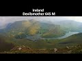
Above Leenane on the Galway/Mayo border sits the Devilsmother ridge. This ridge is home to both the main Devilsmother summit and the Devilsmother North Top which sits at the northern end of the ridge overlooking the Leenane – Westport road. Devilsmother North Top has also been known as Magairlí an Deamhain, or ‘The Demons Testicles’. There is a theory that this actually refers to a couple of knobbly bumps on the ridge as opposed to the northern summit itself. What is clear is that ‘Magairlí an Deamhain’ definitely refers to something here, as evidenced by early 19th century maps.

So how did ‘The Demons Testicles’ end up being translated as ‘Devilsmother’? While I haven’t been able to confirm the origin of this mistranslation, I can offer an anecdotal story about it. In the 19th century British surveyors came to this area.

“What is that mountain there called?’ they asked the locals.

“Magairlí an Deamhain”, they replied.

“What does that mean?” asked the surveyors, keen to get English names for their maps.

“The Demons Testicles”, replied the locals.

“What!” spluttered the offended surveyors. “What kind of unholy name is that? We can’t call it that! We shall have to change it to ‘Devilsmother’ instead. That will be a more acceptable name to have on a map”.

(It is unknown if the locals were being honest about the name, or whether they were just sticking it to the British surveyors!)

Devilsmother North Top can be accessed by parking at a lay by beside a bridge at
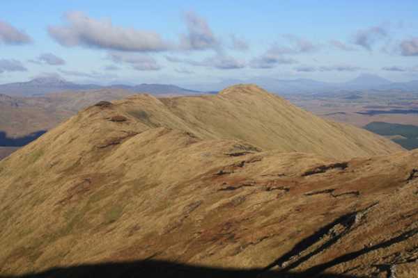
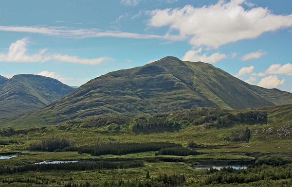
 L935 655 starA. This gives access to the Glenacally valley, which is bounded by the Devilsmother ridge, Maumtrasna and Knocklaur. I was told by a local farmer that access to the valley is permitted. Cross the river and follow a fence into the valley for several hundred metres before heading directly up the steep slopes to gain the Devilsmother ridge. Concentration is needed not to slip on the sodden grass. After climbing 400 metres a level area is reached, with a further 130 metres steep climb to the summit. There are amazing views in all directions of all the main Connemara and Mayo mountains. After such a hard won summit (having had to climb most of its 600 metres), it is a relatively easy walk along the wide ridge to the main Devilsmother summit about 2kms distant. This is well worth the walk as you can then definitely claim to have walked on ‘Magairlí an Deamhain’, as you cross the knobbly bumps along the way! Also the spectacular views of Killary Fjord and points beyond open up as you travel along the ridge. For those with several more hours to spare, the ridge connecting Devilsmother to Knocklaur and Maumtrasna is at about L920 630 starE.

One final word of caution: All the slopes facing into the Gennacally valley, whether from the Devilsmother ridge, Knocklaur or Maumtrasna are very steep, or even cliffs in places. When planning a walk here, ensure you plan the return journey with great care, as it’s easier to climb a wet slope than descend one. Linkback: https://mountainviews.ie/summit/271/comment/6172/
Your Score: Very useful <<  >>Average
 
MountainViews.ie Picture about mountain Devilsmother Far North Top (<i>Magairlí an Deamhain</i>) in area Partry & Joyce, Ireland
Picture: Red line shows the route
 
Descent route from Devil's Mother North Top
by mcrtchly  22 Jan 2013
This photograph shows the descent route that we took from the Devil's Mother North Top as viewed looking north across the Glennacally valley. Navigation is trickly and very steep with dangerous cliffs nearby. For description see route 2060 Linkback: https://mountainviews.ie/summit/271/comment/14907/
Your Score: Very useful <<  >>Average
 
MountainViews.ie Picture about mountain Devilsmother Far North Top (<i>Magairlí an Deamhain</i>) in area Partry & Joyce, Ireland
Picture: Rough north face of Devilsmother N Top.
Why you need to research your way up this one.
by simon3  6 Jul 2012
The extreme roughness of Devilsmother North Top can be seen in this picture taken from the north. There are bands of cliff so it is not surprising that, so far, the two main routes described in MV start from the NE or NW. Linkback: https://mountainviews.ie/summit/271/comment/14708/
Your Score: Very useful <<  >>Average
 
Dan on Devilsmother Far North Top, 2004
by Dan  15 Oct 2004
Did this on a beautiful September day this year (2004). I borrowed a map from a friend and don't have it anymore, so i can't give grid references. Started from the Westport Leenane road. To the north east of the mountain there is a track that starts at the road ( I think its marked on the OS maps). The track is quite obvious from the road, theres two gates at the start of it. Followed the track south as far as a very straight new barbed wire fence and then turned just north of west and followed a wide gully up a few hundred metres. Theres a lot of cliffs on the north face (The North Face, eh!!!), so this gully looked like the best way to avoid them. When I got to the top of the gully, I headed toward the peak, which was to the south west. The view from on top of this, like the view from the Devils Mother is amazing on a good day...particularly the views of the Twelve Bens and The Mweelrea Mountains. The ridge across to the Devils Mother is a nice easy walk. Linkback: https://mountainviews.ie/summit/271/comment/1249/
Your Score: Very useful <<  >>Average
 
(End of comment section for Devilsmother Far North Top (Magairlí an Deamhain).)

OSi logo OSNI/LPS logo
Some mapping:
Open Street Map
(Various variations used.)
British summit data courtesy:
Database of British & Irish Hills
(Creative Commons Licence)
MountainViews.ie, a Hill-walking Website for the island of Ireland. 2300 Summiteers, 1460 Contributors, Newsletter since 2007