Donation Request 2024

DONATE
Members and Supporters, the MountainViews Committee requests your help to meet the costs of the website and of other activities such as insured events or publications.
You do not have to be logged in to donate.
Features
Nearby features appear when you click the map.
Declutter tracks on map.
Place Search
Video
X
Pub: by
Maamturks Area , N: Maumturks N Cen Subarea
Feature count in area: 27, all in Galway, OSI/LPS Maps: 37, 38, 44, 45, EW-CON
Highest Place: Binn idir an dá Log 702m

Starting Places (42) in area Maamturks:
An Móinín Mór, Bealanabrack River Tributary, Bundorragha Estuary Cross, Cannaclossaun, Carraig Bar, Connemara Mountain Hostel, Delphi Resort, Dernasliggaun, Drehidanookera Bridge, Failmore River, Fee Lough SW, Glashmore Bridge, Glencraff Road End, Gleninagh River, Gowlaunlee Lake, Illaunroe South, Killary Boat Tour Pier W, Knocknafaughy SW, Kylemore River, Leenane, Leenane Hotel, unuseableLeenane R336, Lehanagh Lough N, Lehanagh Lough SE, Lough Fee East, Lough Nacarrigeen S, Lough Shindilla S, Maum Bridge Road Lower, Maum Bridge Road Mid, Maum Bridge Road Upper, Maumwee Lough, Nambrackkeagh Lough, Oorid Lough, Owenwee River, Pas Mám Éan CP, Rinavore East, Rinavore SW, Shanvally, Tawnabeg Lough North, Tooreennacoona River, Western Way Cnoc na hUilleann, Western Way Inagh Cottages

Summits & other features in area Maamturks:
N: Leenaun: Maumturkmore 488m, Búcán 550m, Leenaun Hill 618m, Leenaun Hill Far North-West Top 556m, Lettershanbally 324m, Meall Cheo 578m, Taobh Dubh 422m
N: Maumturks N Cen: Barrlugrevagh 558m, Letterbreckaun 667m, Letterbreckaun NE Top 603m, Knocknahillion 607m, Knocknahillion North Top 541m, Cúlóg 435m
S: Maumturks S Cen: Binn Chaonaigh 633.5m, Binn idir an dá Log 702m, Binn idir an dá Log SE Top 659.3m, Binn Mhairg 612.4m, Knocknagur 310m
S: Maumturks South: Binn Mhór 660.6m, Binn Mhór NE Top 641.2m, Binn Mhor West Top 595.8m, Binn Mhor East Top 631.3m, Lissoughter 401m, Corcogemore 610.1m, Mullach Glas NE Top 432m, Lackavrea 396m, Mullach Glas 621.3m

Note: this list of places may include island features such as summits, but not islands as such.
Rating graphic.
Knocknahillion, 607m Mountain Cnoc na hUilleann A name in Irish,
Place Rating ..
(Ir. Cnoc na hUilleann Thiar [TR], 'hill of Uillinn Thiar'), Galway County in Connacht province, in Arderin, Vandeleur-Lynam, Irish Best Hundred Lists, Cnoc na hUilleann is the 273rd highest place in Ireland.
Grid Reference L87036 53756, OS 1:50k mapsheet 37
Place visited by: 303 members, recently by: TipsyDempy, therealcrow, taramatthews, PiotrR, maoris, Prem, Carolineswalsh, knightsonhikes, Kaszmirek78, Moirabourke, mdehantschutter, Arcticaurora, Krzysztof_K, CaminoPat, farmerjoe
I visited this place: NO (You need to be a logged-in member for this.)
Longitude: -9.703964, Latitude: 53.521816, Easting: 87036, Northing: 253756, Prominence: 152m,  Isolation: 0.8km
ITM: 487009 753778
Bedrock type: Pale quartzites, grits, graphitic top, (Bennabeola Quartzite Formation)
Notes on name: Rather than a hill-name, Uillinn Thiar is the name of a townland meaning 'elbow - west'.
  Short or GPS IDs, 6 char: Kncknh, 10 char: Kncknhln

Linkback: https://mountainviews.ie/summit/260/
Gallery for Knocknahillion (Cnoc na hUilleann) and surrounds
No summary yet for this place .
Member Comments for Knocknahillion (Cnoc na hUilleann)
Comment create / edit display placeholder

            MountainViews.ie picture about Knocknahillion (<em>Cnoc na hUilleann</em>)
Picture: Looking to Lough Mam Ochoige from slopes of Knocknahillion
Of Mice and Men
by wicklore 26 Nov 2010
Or more precisely, of Meis and (Sheep Rustling) Men!

The Glenlosh Valley is a wide isolated valley to the east of the Maamturks in Connemara. It is bounded to the west by the Knocknahillion - Binn Bhriocan – Maumturkmore section of the Maamturks ridge. Across the valley to the north and east are Leenane Hill and Taobh Dubh which hide the valley from the busy Maam- Leenane road. Glenlosh is a privately owned 1700 hectare estate with a road running up through the valley. It was along this road, at G'laun L (L G'laun L (L879 557)) that I parked in order to follow a green road up towards Mam Ochoige. The drive to this point is worthwhile in itself to enjoy the surrounding valley views and savour the isolated feel of the area. There are a small number of holiday cottages scattered along the route but they were all empty when I was there last week

While I was kitting out for my walk I heard the slow crunching of a car as it rolled softly along the road towards me. I looked up to see an elderly lady eyeing me with a mixture of curiosity, suspicion and bemusement from her jeep. As in all such encounters with locals I stepped over to ask about access and permission to park etc. A pleasant conversation ensued.

Her name was Mrs. Meis and she is the owner of a vast amount of the Glenlosh Valley, the holiday cottages and the access road we were on. She confirmed that it was ok to park at that spot, but I could see she appreciated being asked. She mentioned that if I met her husband that I was to tell him Mrs. Meis had granted permission for me to be on their land. Their home and offices are the last property at the end of the valley road, so if in doubt about parking in the valley take a trip up and enquire. As we chatted Mrs. Meis told me about a terrible problem they are suffering with sheep rustling in the area. Her family has lost over 100 sheep, and she expressed happiness that I would be up in the hills as this would deter any would-be rustlers who were about. She said herself and her husband couldn’t patrol all of their land and having walkers about could be useful. She confirmed that the Gardai are investigating the issue.

This starting place will take you along a marshy green track to its end at A (L87833 54118), from where it is a climb of about 170 metres up the wet slopes to Mam Ochoige at B (L87721 53749). From here you can enjoy views back to Lough Mam Ochoige as you climb north and west over increasingly rocky ground to Knocknahillion. With an ascent of about 600 metres over 4kms distance, it should take about 2 hours to reach Knocknahillion along this route. It is an easy enough (for the Maumturks!) access route to these impressive mountains. Just watch out for Meis and (sheep rustling) men along the way! Linkback: mountainviews.ie/summit/260/comment/6165/
Read Less
Read More

            MountainViews.ie picture about Knocknahillion (<em>Cnoc na hUilleann</em>)
Picture: L to R: Binn idir an dá Log, Cashel Hill, Knocknahillion, Derryclare, Letterbreckaun
A day and a night in Joyce Country
by Phahie 1 Jul 2012
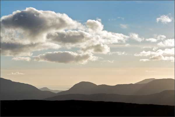
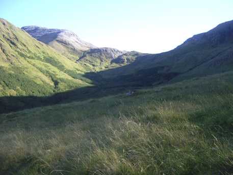
As you drive from Maum to Leenaun (on the R336), there's a road that brings you into the Maumturks from the northeast. In February 2011, I drove into Gleann Glaise to explore this remote corner of Joyce Country. The road winds it's way into the valley where you're quickly surrounded by mountains and a wonderful feeling of remoteness. I parked on a gravel lay-by about half way up the valley Bl'brack Tri (L8835 5525) and headed for Maumahoge 
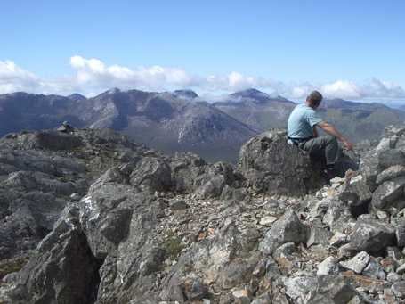
C (L8776 5371). Stopping for lunch on the summit of Knocknahillion, the panorama stretched from Mweelrea to the north, rising above Killary Harbour, to the maze of watery ground extending to Galway Bay to the south. I continued over Letterbreckaun, my high point for the day, and by the time I reached the holy well at Tobar Feichin D (L8578 5640) the sun was setting behind the Bens and it was time to head back down to Gleann Glaise. I got back to the van as the first star twinkled and my head-torch battery dwindled. Just as well I didn't really need to use it... or so I thought.

As I attempted to reverse out onto the road, rather than move backward, I seemed to be moving downward. I got out to inspect the situation and, with my torch now completely dead, I assessed the damage by touch. As the wheels turned the stones had parted, exposing the bog beneath. The rear wheels were now well below ground, rendering movement in any direction extremely unlikely. I was in a remote valley, out of mobile phone coverage, stuck in a bog, alone, in the dark... great!

That first star was now joined by a host of heavenly beauties. As I marvelled at the unfolding spectacle I tripped over a concrete block that was lying by the side of the road. This got me thinking... Raising one wheel at a time and using various found objects I managed to regain buoyancy and traction. A series of three point turn manoeuvres followed, repeating the concrete block and jack assembly with each change of direction, but by the time the novelty of all this was wearing off I realised I'd boxed myself into a corner and I wasn't going to be able to get out - not in the dark anyway.

What to do... I didn't fancy the long walk out to god knows where so I decided to sleep in the van and see what the morning would bring. Morning brought confirmation that I wasn't going to get out of this unaided, so after a fig-roll breakfast, I started my long trek out of the valley, leaving the van stranded in what now resembled the site of an archaeological dig.

Miraculously, within minutes of leaving my encampment, an old Transit van puffed its way up the road towards me. Clearly visible through the front window were three Connemara men - forestry men! I told them my story and with some strategic redistribution of gravel and six large hands placed against the back of the van, I drove gingerly but triumphantly back onto the road. We shook hands, discussed the recent election results, and went our separate ways. Linkback: mountainviews.ie/summit/260/comment/14701/
Read Less
Read More

Knocknahillion from the west.
by markwallace 11 Oct 2013
Climbed Knocknahillion from the west on a slightly overcast September day, setting off from the point where the western way meets the Ilion road (around WW Cnc Uil (L859 533)). I took the route along the stream that goes up to the left of Knocknahillion (from that vantage point), and followed it up about 430m - a stiff but straightforward climb - into a high sheltered hollow with peaks on three sides, a rocky landscape, and a few ovine inhabitants who eyed me warily. Here the stream veered left, but I kept on straight to the peak ahead, called Maumean (541m) on my OS37 (but which I now see is called Knocknahillion North Top here). The wind was really lashing up here, and I pondered the name "Pass of the Birds" - birds might consider this a mountain pass, but nothing earthbound. The eastern slopes of Mamean looked really precipitous, almost or totally impassable. The ascent to Knocknahillion is easy from here, though.

From Knocknahillion's top, I went for the direct descent in a WSW direction to the road. Not recommended. I ended up doing some quite hairy scrambling. If I did it again, I'd probably take the same ascent, including Maumean/ North Top, but descend through Maumahoge. The mountain was as wild, windy and deserted as you could wish, and the journey probably took two-and-a-half hours, including short breaks, at a leisurely pace. Linkback: mountainviews.ie/summit/260/comment/15192/
Read Less
Read More

            MountainViews.ie picture about Knocknahillion (<em>Cnoc na hUilleann</em>)
Picture: Maumahoge from Glenglosh
madfrankie on Knocknahillion
by madfrankie 19 Sep 2007
The col of Maumahoge is to the soth-west of Cnoc na hUilleann, and though more frequently approached from the south, the col can be handily accessed from the north.
We left the tarmac road in the Glenglosh valley at point G'laun L (L879 557), just where a green road ascended gently south into the valley, passing one of the Glenglosh holiday cottages. Just before this green road petered out we climbed directly to the rocky col. Binn Idir An Da Log towers to the SE, but we turned north-west (right) up the rocky slopes. The hitherto unseen lough nestling beneath Binn Idir An Da Log slowly comes into view. A minor cairn en route could confuse in mist. Great views at summit marred by a nest of flying ants hovering just above the cairn. Linkback: mountainviews.ie/summit/260/comment/2834/
Read Less
Read More

            MountainViews.ie picture about Knocknahillion (<em>Cnoc na hUilleann</em>)
madfrankie on Knocknahillion
by madfrankie 19 Sep 2007
The stony summit of Cnoc na hUilleann, looking south east towards Binn Idir An Da Log Linkback: mountainviews.ie/summit/260/comment/2835/
Read Less
Read More
EDIT Point of Interest
text
Videos


Recent Contributions
x
Conditions and Info
Use of MountainViews is governed by conditions and a privacy policy.
Read general information about the site.
Opinions in material here are not necessarily endorsed by MountainViews.
Hillwalking is a risk sport. Information in comments, walks, shared GPS tracks or about starting places may not be accurate for example as regards safety or access permission. You are responsible for your safety and your permission to walk.
See the credits and list definitions.

OSi logo
OSNI/LPS logo
Open Street Map
(Various variations used.)
British summit data courtesy:
Database of British & Irish Hills