Donation Request 2024

DONATE
Members and Supporters, the MountainViews Committee requests your help to meet the costs of the website and of other activities such as insured events or publications.
You do not have to be logged in to donate.
Features
Nearby features appear when you click the map.
Declutter tracks on map.
Place Search
Video
X
Pub: by
Mangerton Area , Cen: Dromderlough Subarea
Feature count in area: 28, all in Kerry, OSI/LPS Maps: 78, 79, EW-KNP, EW-R
Highest Place: Mangerton 838.2m

Starting Places (30) in area Mangerton:
Cummeenboy Stream, Derrycunihy Church, Dunkerron Mid, Garries Bridge, Gowlane School Ruin, Hidden Valley Pet Farm, Inchimore West, Kenmare Bridge, Killarney Hiking Parking Lot, Knockanaskill N, Knocknsallagh Bridge, Loo River Junction, Looscaunagh Lough W, Lough Barfinnihy CP, Lough Guitane E, Lough Guitane SE, Lough Guitane W, Lynes Farm, Mangerton Walk N CP, Mangerton Walk Start, Molls Gap, Muckross Lake S, Old Rail Level Crossing, Poulacapple, River Roughty, Rossacroo na Loo Forest, Sahaleen Bridge, Shaking Rock W, Shronaboy Farm MTB, Torc Waterfall CP

Summits & other features in area Mangerton:
Cen: Dromderlough: Dromderalough 650m, Dromderalough NE Top 654m, Dromderalough NW Top 625m, Knockbrack 610m, Knockrower 554m, Shaking Rock 402m
Cen: Inchimore: Inchimore 256m
Cen: Mangerton: Glencappul Top 700m, Mangerton 838.2m, Mangerton North Top 782m, Stoompa 705m, Stoompa East Top 608m
NE: Crohane: Bennaunmore 454m, Carrigawaddra 425m, Crohane 650m, Crohane SW Top 477m
NW: Torc: Cromaglan Mountain 371m, Torc Mountain 534.8m, Torc Mountain West Top 479.4m
SE: Esknabrock: Esknabrock 406m
SW: Peakeens: Derrygarriff 492m, Derrygarriff West Top 382m, Foardal 409.8m, Knockanaguish 509m, Peakeen Mountain 554.7m, Peakeen Mountain Far NW Top 525.5m, Peakeen Mountain North-West Top 522.7m, Peakeen Mountain West Top 538.7m

Note: this list of places may include island features such as summits, but not islands as such.
Rating graphic.
Knockbrack, 610m Mountain Cnoc Breac A name in Irish,
Place Rating ..
(prob. Ir. Cnoc Breac [PDT], 'speckled hill'), Kerry County in Munster province, in Arderin, Vandeleur-Lynam Lists, Knockbrack is the 267th highest place in Ireland.
Grid Reference V95410 77938, OS 1:50k mapsheet 78
Place visited by: 114 members, recently by: maoris, Carolineswalsh, SeanPurcell, ToughSoles, SmirkyQuill, Ansarlodge, Krzysztof_K, Superterence, Hjonna, johncusack, eoghancarton, nevgeoran, a3642278, Taisce, chelman7
I visited this place: NO (You need to be a logged-in member for this.)
Longitude: -9.521342, Latitude: 51.944122, Easting: 95410, Northing: 77938, Prominence: 45m,  Isolation: 1.3km
ITM: 495408 577984
Bedrock type: Green sandstone & purple siltstone, (Glenflesk Chloritic Sandstone Formation)
Notes on name: The top is rather indistinct and difficult to find, which is characteristic of a a number of peaks on the plateau SW of Mangerton.
  Short or GPS IDs, 6 char: Knckbr, 10 char: Knockbrack

Linkback: https://mountainviews.ie/summit/255/
Gallery for Knockbrack (Cnoc Breac) and surrounds
Summary for Knockbrack (Cnoc Breac): Broad, rocky summit with fine views
Summary created by Colin Murphy 2015-04-24 09:57:16
            MountainViews.ie picture about Knockbrack (<em>Cnoc Breac</em>)
Picture: Summit market with small pool
See Knockrower short summary for initial approach. From track at Point A (V925 775) turn east and head directly up the valley between Coombane and Knockrower. There is a track visible in parts, apparently the result of a quad bike, but which if you happen upon it, it acts as a useful guide as it meanders for a couple of km up the valley. After 1km the ground becomes steeper and in clear weather, Knockbrack will be visible on your right. There is extensive forestry indicated on the OS map, but there is no evidence of a forest ever having been here. Continue another 1km past Lough Nambrackdarrig and the ascend to the SE, the slope quite steep in places. Two small, but quite beautiful loughs nestle in the northern slopes of the mountain. The summit is a broad, rocky/grassy area and a fairly substantial layered pile of stones on the south of this area marks a false high point - the true high point is indicated by a smaller pile of stone to the south of the summit area (pictured, with false high point inset). Allow 2 hours from car to top.
Linkback: mountainviews.ie/summit/255/comment/5015/
Member Comments for Knockbrack (Cnoc Breac)
Comment create / edit display placeholder

ibradley on Knockbrack
by ibradley 18 Nov 2005
Climbed Knockbrack and Dromderalough on 13/11/05 which was a bright but cold day.
The minor road on the right is on the Kenmare side of Kilgarvan, just after the sign for the GAA grounds but before the Michael J Quill Memorial Centre. There is a right turn roadsign about 100m before the minor road.
As it was such a fine day, I decided to park just south of Mangerton Bridge at B (V995 762) using a good layby on the right. I then followed the road north, then west to the last farm at the end on my right. Here, you will see the rather intimidating Private Property signs as mentioned by mat in his comments on Dromderalough. I counted 3 of these signs, but a 4x4 vehicle passed me at the entrance to the forest and I was not challenged.
I would suggest following the route up Knockbrack as described by Grumbler#1 in his comments on this mountain. Paddy Dillon in his book The Mountains of Ireland suggests leaving the track at the forest entrance and following the forest boundary fence in a north-westerly direction. Staying on the forest track is an easier option, although perhaps slightly further. Look out for the sheep fence on the final approach to Knockbrack, complete with a barbed-wire top. Views from the top are good, with the Reeks, Stumpa Duloigh and Mullaghanattin all prominent. I encountered a small group of red deer just north of the summit on the way to Dromderalough.
Dromderalough appears to have 3 separate summits, all marked by cairns. I continued on to Mangerton, which involves crossing some very rough and wet bog. This was hard going, and adds around 2 hours to the walk if you return to Dromderalough from Mangerton. On top of Mangerton, there was a group of at least 30 school children. On returning to Dromderalough, I descended south-easterly across open hillside to return to the entrance to the forest. Here, you can rejoin the forest track next to some sheep pens. As I walked past the last farm on the way out, I met the farmer. He told me the signs had been put there by the company (South West Forestry) which manages the forest. Parking in the forest is possible, but may not be a good idea in view of the private property signs. The road walk to and from Mangerton Bridge adds around 4km in total, but serves as a good warm up/warm down. Parking here is also not obstructive in any way.
Knockbrack and Dromderalough may not be the most spectacular hills in the area, but are well worth the effort. Linkback: mountainviews.ie/summit/255/comment/2055/
Read Less
Read More

Grumbler#1 on Knockbrack
by Grumbler#1 31 Jul 2003
Some mountains, like Errigal, are great because of their aesthetic beauty, others are great because of their technical difficulty. Knockbrack is neither. Nevertheless, this was a great day, and this small bump will be remembered by the other Grumblers when we have forgotten bigger hills.
Grumbler #2 (aka "Trip" ...a great nickname for a climber!) and myself had a little race going on. Who would be first to finish all the 2000ft peaks in Ireland? Trip had one left.....Knockbrack, he'd missed it when on Mangerton, as the OSI don't give a spot height). So we had to make a weekend of it, Big Jock came over from Glasgow but his brother "Mad Jock" had just secured a job and sent an apology in the form of a bottle. Being a special weekend, various honorary Grumblers also came along and a plan was formed. Day 1 Galtees, Day 2 The pocket, Day 3 Whatever, Day 4 Knockbrack. Day 1 was torrential and cold as winter (it was only May after all), Day 2 started gloriously but we were denied access to Mullaghnattin from the South by an irate farmer (tip: don't ask permission) I'll post the Ballachabeema route epic soon. Day 3 being Sunday meant Knocknadobar via the stations, followed by too many pints in the Roughty bar in Kenmare (and not enough elsewhere).

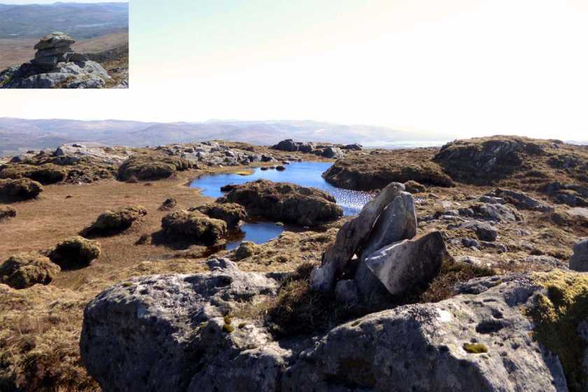
So the big day dawned, totally hungover and dehydrated. The biggest navigation problem was finding Mangerton Bridge (C (V995 762)) and the road below Carrigagreenaun. Parked at the end of the road taking care not to block the new sheep pens. Keeping to the right (and then turning right) on the forestry track, plodded gradually uphill with a head thumping like drum. Track swung left (W) again and zig-zagged up to the end of the forestry as the clouds and our heads cleared. The track dropped us by a fence and a stiff 150m or so pull NW saw most of us on the top. Trip was with the "auld wans" so big Jock ran around the 4 bumps with his GPS to let us know that the "wee cairn" we stood by was the summit. True baggers will need to satisfy themselves and do all 4 peat hags, Good views though. Finally grumbler #2 reached the top. (Sensitive souls and puritanical sorts stop reading now) Whiskey was produced, of the Scottish Malt variety. Lots, and by god it was marvellous! Photos were taken, hands shaken, I admitted defeat. The conversation began "Perhaps the 600m tops? or highest point in each county?" "Whats the highest point in Kildare...the bar stool in The Kitchen...." We continued on elated to Dromderalough for more traditional food and drink and shelter from a passing shower and discussions, lists, and thoughts of new routes on proper mountains. Looked at Glencappul SE Top, the Grumblers Executive (me) decided that it was dubious to accord it separate status to Mangerton, while Big Jock laughed (no doubt the SMC has a special committee and teams of surveyors for such things). Dropped S, down the least boggy gully to reach the Owbaun river and a track by a fence. At the end we kept left (E) to avoid walking by the farmhouse, to regain the road. A quick trot up the road, a wash in the stream and back home.
Thoughts from the barstool in "The Kitchen": If you want an easy day at the end of a weekend's walking, to stretch your legs, or can not face the drive back to the Pale, you could do worse than this. Linkback: mountainviews.ie/summit/255/comment/595/
Read Less
Read More

Conor74 on Knockbrack
by Conor74 10 Mar 2009
Climbed Knockbrack on the 08/03/2009, from a different side to those in other comments. Left car at Gowlane Cross (91751), about 2 miles from Kenmare town (past the Church and schools and straight on), and walked north east along the tarred road. After approximately half a mile, there is a large newly build shed just off the tarred road on the left hand side (D (V924 758)) with a gate in front which is just closed by a wire. I left the tarred road and went through the gate, past the shed and up a track that leads from behind the shed along by the base of Knockaganuish Mountain on the left (West) wide and on to Cummerslaun Lake. Near the lake a river crosses over the track, and at this point (E (V925 774)) I turned off the track and followed the river back to its source, Lough Nambrackdarrig, which is in the valley between Knockrower, Dromdiralough and Knockrower. Going wasn't easy as weather was very bad, snowing and windy, but terrain was fine - though should bear in mind that the north side of the river has a track carved by quad bikes and there are few natural fording points in the river during rain. When I got to the lake, (F (V944 783)) I headed south east across about 50 yards of very boggy ground towards a very distinct rock on the west side of Knockrower which is clearly visible against the sky, and from there made my way east to the summit. Some rocks and boulders, and one set of crags about half way up and which are easy enough to get around, but otherwise no real obstacles. The top is not very clealy defined, no cairn, so its a bit of guessing and sizing one outcrop of rock against another. In wandering around the top I found the two lakes marked in all maps near the top, on the day I was there one was all but frozen over. Some spectacular scenery from the summit, though the conditions were alpine with snow and a strong gale which almost bowled me over a few times. No big cliffs though, pretty safe there. Walked down pretty much the same route, though this time circled Lough Nambrackdarrig to the east and north before finding the river again and following it back to Cummerslaun. Overall it took about 4 hours, though stopped a lot to take photos. Linkback: mountainviews.ie/summit/255/comment/3635/
Read Less
Read More

            MountainViews.ie picture about Knockbrack (<em>Cnoc Breac</em>)
Picture: View across to Reeks
Nondescript Summit with Expansive Views in Wild Country
by ciarraioch 4 Nov 2012
We took in Cnoc Breac as an extension from Drom Doire Loch (see associated entry). Looking deceptively close, it took a good half hour across rocky and water logged ground. Expansive views across Beara to the Cow and the Bull Rocks. The latter, formerly Teach Duinn, was a gateway to the underworld in the old religion. We continued via Loch na mBreac Dearg (Red Trout Lake) towards Cnoc Ramhar/Knockrour. Linkback: mountainviews.ie/summit/255/comment/14856/
Read Less
Read More

Conor74 on Knockbrack
by Conor74 1 May 2009
As an interesting detour, and for a fun scramble down a steep incline, if one walks from Knockbrack east south east towards Knockanganuish, staying to the south of the valley through which the river from Lough Nambrackdarrig runs (is this the Ullauns River? Think it's noted as such in McGonigle's Guide to the Killarney outback) there is a ridge which leads to an area containing forestry. When you find the forestry at G (V935 773) turn south and follow its north east boundary. After about 10 minutes walk (maybe 25 mins from Knockrower summit) you will find a stream beside an area of forestry that looks like it was burned in recent years. Stay as close to that stream as possible, even though the going can be sticky and boggy - it becomes a spectacular waterfall dropping about 100m through the forestry, and great fun can be had scrambling down beside it. Rocks in it are very slippy though, so take care or you'll end up on your seat. At the bottom, there is a path which takes you back to a track at at H (V925 770), and eventually back to a tarred road near the Old Killarney Road. Linkback: mountainviews.ie/summit/255/comment/3741/
Read Less
Read More
EDIT Point of Interest
text
Videos


Recent Contributions
x
Conditions and Info
Use of MountainViews is governed by conditions and a privacy policy.
Read general information about the site.
Opinions in material here are not necessarily endorsed by MountainViews.
Hillwalking is a risk sport. Information in comments, walks, shared GPS tracks or about starting places may not be accurate for example as regards safety or access permission. You are responsible for your safety and your permission to walk.
See the credits and list definitions.

OSi logo
OSNI/LPS logo
Open Street Map
(Various variations used.)
British summit data courtesy:
Database of British & Irish Hills